Join us for the 17th Annual Professional Snow and Avalanche Workshop (PROSAW) on November 4 - Purchase tickets here!

Forecast for the Uintas Area Mountains

Craig Gordon
Issued by Craig Gordon on
Saturday morning, February 17, 2024
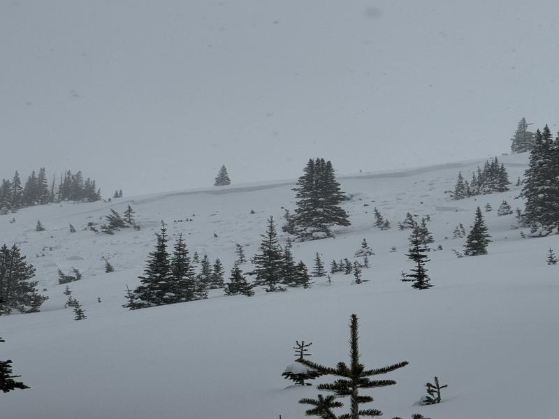
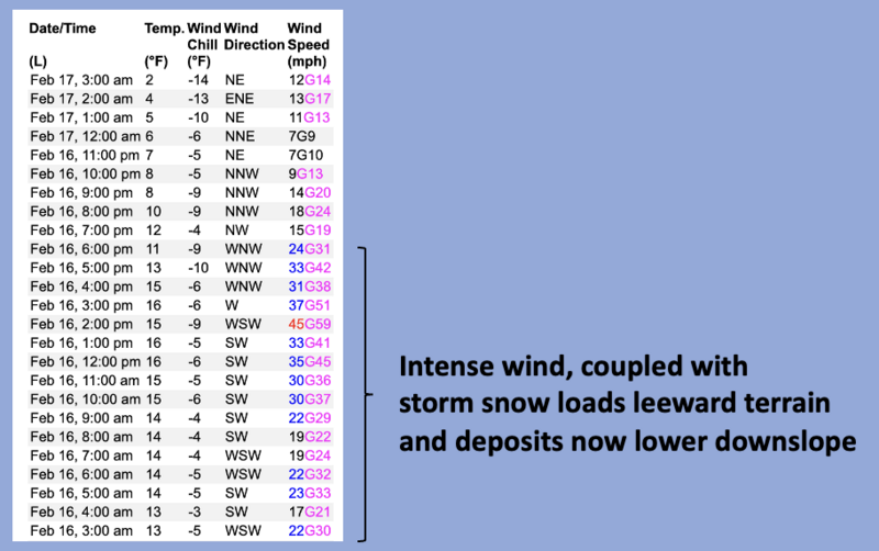
Don't let the intoxicating mix of bright sunshine and fresh pow alter your decision making process today-
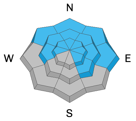
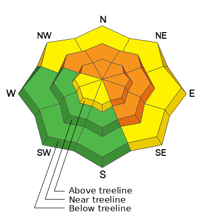
At and above treeline you'll find CONSIDERABLE avalanche danger today. Human triggered avalanches are LIKELY especially in terrain facing the north half of the compass. Disclaimer... don't remove this tag and don't get lulled into thinking storm snow and fresh drifts are the only avalanche game in town. Steep, rocky slopes with a shallow, weak snowpack have the potential to produce a slide that fails on sugary, weak layers, now buried a few feet from the snow surface. And remember... any slide that breaks to old snow instantly ruins your day.

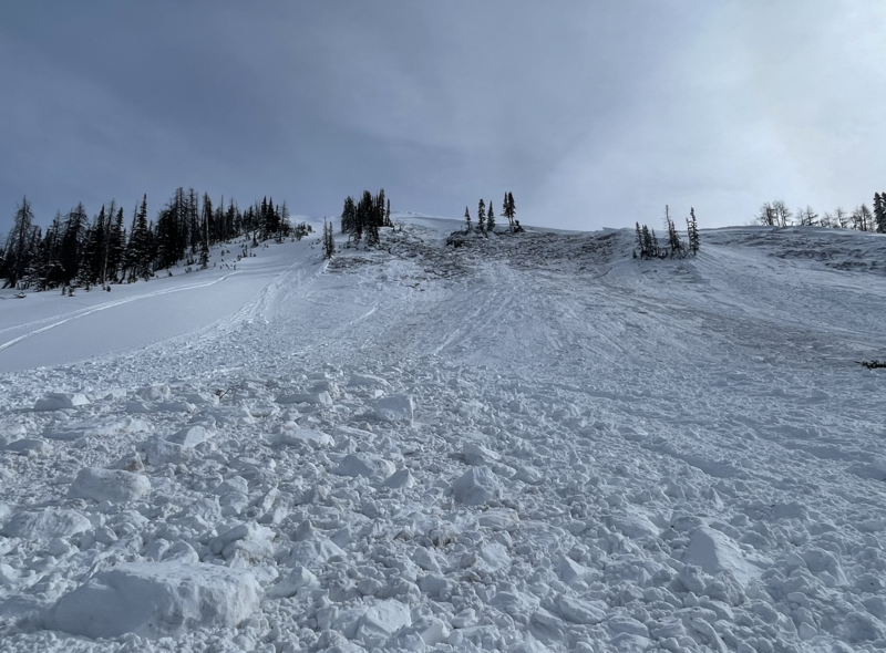
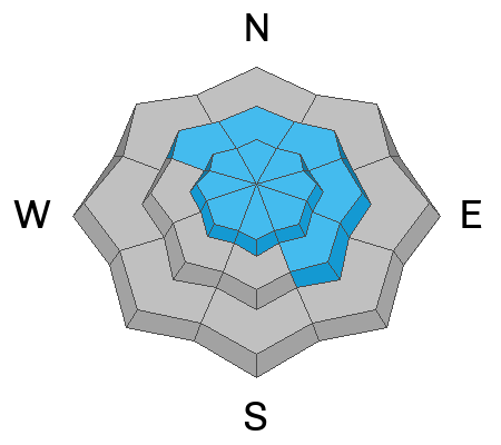
Recent wind and storm snow light up lower elevation shady slopes where you'll find MODERATE avalanche danger. Human triggered avalanches are POSSIBLE on steep, wind drifted, northerly facing slopes.

Mid and lower elevation south facing terrain offers glorious snow and generally LOW avalanche danger.
Low
Moderate
Considerable
High
Extreme
Learn how to read the forecast here
Special Announcements
We are seeking a passionate individual to join us as Executive Director of the nonprofit Utah Avalanche Center. Click here for more information.
Weather and Snow
Nowcast- Friday's high energy storm blew into town like a stop on a mid 90's Warped Tour and immediately took to the mosh pit, delivered some body slamming antics, lingered long enough so we have a distinct recollection the morning after, but packed it's bags overnight and is headed east for the next leg of the tour. In its wake, storm totals are evenly stacked up across the range with roughly 4" of snow and .25" H2O. Skies cleared overnight, temperatures register in the single digits, while winds blow from the northeast in the teens and mid 20's near the high peaks. I think our high elevation alpine terrain experienced a bit of wind damage, but on a go-anywhere base, head to wind sheltered terrain where you'll find snow conditions about as good as it gets!
Forecast- Get out and get it while you can... a stunning day is on tap. Expect sunny skies with temperatures climbing into the mid 20's, while north and northeast winds blow 15-25 mph near the high peaks. Clouds increase overnight and low temperatures dip into the teens.
Futurecast- It looks like a quick hitting storm slides into the region Sunday morning, delivering 3"-5" of snow before clearing out overnight. Expect a break on Monday with another storm in the queue for Tuesday through midweek.
Snow coverage is excellent with soft, dry powder on the polars.
Total snow depths/total water at Uinta SNOTEL sites:
Chalk Creek #1 (9,171') - 60"/14.6"
Hayden Fork (9,130') - 48"/12"
Trial Lake (9,992) - 67"/16.3"
Wolf Creek Peak (9,796) - 61"/14"
Currant Creek (7,915') - 39"/9.7"
Strawberry Divide (8,123') - 54"/15.2"
Recent Avalanches
On Thursday, Avy-savvy guide du jour, Wes Shirey reported very touchy fresh wind drifts in the Wolf Creek zone, and spotted this large, natural avalanche breaking 3'-4' deep and 200' wide. Pictured above, the slide failed on old snow, in steep, leeward terrain at 9,800'.
Also, on Monday, Joey and I investigated a large, snowmobile triggered slide in Upper Chalk Creek. Breaking 6'-10' deep and 600' wide resulting in a VERY CLOSE CALL on Sunday, February 11th. All the deets are found HERE.

For more Uinta observations and recent avalanche activity click HERE.
Ad
Avalanche Problem #1
Persistent Weak Layer
Type
Location
Likelihood
Size
Description
Steep, rocky, heavily wind loaded slopes like in the image above from last weeks close call in Chalk Creek, remain the prime suspect terrain to continue avoiding.
The burning snowpack stability question that keeps racing through my mind is... can I trigger an avalanche that breaks into weak layers of snow, and if so... where?
All the recent avalanches I've been crawling around and investigating have been triggered in upper elevation, steep, rocky terrain with a shallow, weak snowpack on slopes facing the north half of the compass. The complex notion is... these slopes are thin because they've either avalanched multiple times this year, like Sunday's close call in Chalk Creek, or they've been stripped by one wind event and then reloaded by another wind event from a different direction... or both! Now of course, my mind is spinning!
Knowing I'm not going to outsmart this avalanche dragon, we instead agree to disagree. I'll avoid steep, rocky, mid and upper elevation terrain facing the north half of the compass, where the odds of triggering a slide lessen over time, but the consequences remain severe. I'll stick with lower angle shady slopes, or if I wanna get in bigger terrain, I simply switch aspect and head to the sunnies.
With all the great riding to be had, there's no reason the pull on the dogs tail, cause its bite is worse than its bark!
Avalanche Problem #2
Wind Drifted Snow
Type
Location
Likelihood
Size
Description
A 24 hour data dump from Windy Peak illustrates strong winds which load leeward slopes and terrain features like chutes and gullies.
There's no shortage of snow to blow around and recent winds continue whipping up additional rounds of wind drifted snow. Found mostly in mid and upper elevation, leeward terrain facing the north half of the compass, look for a few rogue drifts on south facing slopes and cross-loaded in terrain features like chutes and gullies. In any case, this is a manageable avalanche dragon as fresh drifts are easy to detect by their fat, rounded appearance. Lose the wind and you lose the problem.
Additional Information
The Uinta weather station network was upgraded this summer and all that real-time info is found HERE. Simply click on "western Uinta" tab and then "weather stations" tab.

We are always looking for snow and avalanche observations or just general riding conditions. So... if you see something, say something. You can reach me directly at [email protected] or 801-231-2170.
Also, if you're looking for more avy education opportunities for yourself, your crew, or your club please don't hesitate to reach out to me and we'll find a presentation, class, or clinic for ya!
General Announcements

Issued at 0400 on Saturday, February 17th this forecast will be updated by 0700 Sunday, February 18th, 2024.
This forecast is from the U.S.D.A. Forest Service, which is solely responsible for its content. This forecast describes general avalanche conditions and local variations always occur.