Forecast for the Uintas Area Mountains

Craig Gordon
Issued by Craig Gordon for
Friday, February 17, 2023
Overall, the avalanche danger is LOW and human triggered avalanches UNLIKELY as much of the range is still reeling from the carnage of the midweek wind event.

Low
Moderate
Considerable
High
Extreme
Learn how to read the forecast here
Weather and Snow
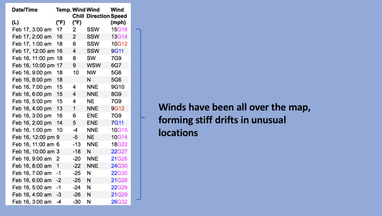
Nowcast- High pressure over the region delivers clear skies and much warmer temperatures, currently registering in the low to mid teens... about 10 degrees warmer than yesterday at this time. Winds switched to the southwest at the turn of the new day and blow 10-15 mph near the high peaks. Riding and turning conditions took a hard hit from the cow-tipping, midweek, wind event. But, I bet if you hunt around long enough, you'll find limited swaths of shallow, creamy snow on very wind sheltered, mid elevation slopes.
Forecast- Expect sunny skies with temperatures creeping out of the deep freeze and into the high 20's. Southwest winds blow in the 20's and 30's along the high ridges.
Futurecast- Clouds drift into the area overnight bringing a flurry or two along for the ride, but we should see clearing skies by early Saturday morning. The weather then takes an interesting turn early in the upcoming work week. And while our computer models suggest storminess, the when, where, and how much remain elusive. I'll update y'all with the deets as the strength and timing become more clear.
Huge thanks for all the great obs streaming in from the eastern front. Even more detailed trip reports and recent obs are found HERE.
Recent Avalanches
No significant avalanche activity to report, but if ya wanna geek out, click HERE to track this years slide activity throughout the range.
Ad
Avalanche Problem #1
Wind Drifted Snow
Type
Location
Likelihood
Size
Description
Winds have blown from every quadrant of the compass and the snow in most of our terrain is wind-pressed rather than wind loaded. However, there may be a rogue wind drift or two reactive to our additional weight on the leeward side of ridges and around terrain features like chutes or gullies. Remember to look for and avoid hard, stiff, pieces of snow, especially if they sound hollow like a drum.

Additional Information
Weather stations-
And... rime events have severely crippled the Uinta weather station network. I'm working to get it back up and running, but a few stations are found HERE (click weather stations, and then on the Western Uinta tab)
Observations-
Your observations are important, so please let me know what you're seeing... click HERE and contribute to this amazing community-based program
General Announcements
Issued at 03:22 on Friday February 17th, this forecast expires 24 hours after the date and time posted, but will be updated by 07:00 Saturday February 18th 2023.
Before it gets too crazy, now is the time to book an avalanche awareness presentation for your group, club, or posse. You can reach Craig directly at 801-231-2170 or [email protected].

This forecast is from the U.S.D.A. Forest Service, which is solely responsible for its content. This forecast describes general avalanche conditions and local variations always occur.