Forecast for the Uintas Area Mountains

Craig Gordon
Issued by Craig Gordon for
Thursday, February 16, 2023
A rogue wind drift or two may exist on leeward slopes with a south or west component to its aspect. However, the overall avalanche danger is LOW and human triggered avalanches UNLIKELY as recent hurricane force winds either welded the snow in place or transported it to neighboring states.

Low
Moderate
Considerable
High
Extreme
Learn how to read the forecast here
Weather and Snow
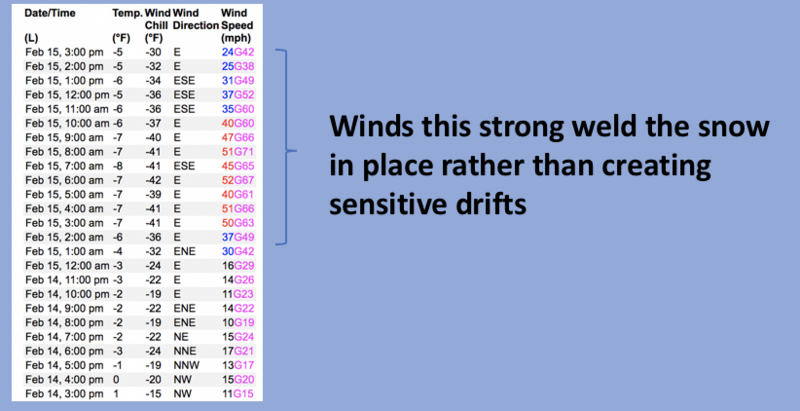
Nowcast- This mornings clear skies, temperatures near -10 degrees, and northeast winds blowing 15-30 mph along the high ridges, paints a skewed snapshot of our recent weather. Instead... picture if you can, the highest mountain range in the contiguous United States that runs east-west and let's called it the western Uinta's. Take that same range and blast it with east and northeast winds consistently blowing in the 50's and 60's for nearly 24 hours, throw in a few gusts to 90 mph, and just like a forgotten Portobello in the dark recesses of a Traeger grill, you've created a snow surface that resembles something a lunar rover would land on. Yeah... not only vast swaths of terrain, but nearly every square inch of snow is TORCHED!
Forecast- On the brighter side... look for mostly sunny skies, temperatures climbing into the teens and low 20's, with northerly winds blowing in the 20's and 30's near the high peaks.
Futurecast- Not much going on in the weather department until late Sunday when I'm cautiously optimistic we return to a warmer, wetter pattern. I'll keep ya updated as details evolve.

Huge thanks for all the great obs streaming in from the eastern front. Even more detailed trip reports and recent obs are found HERE.
Recent Avalanches
No significant avalanche activity to report, but if ya wanna geek out, click HERE to track this years slide activity throughout the range.
Ad
Avalanche Problem #1
Wind Drifted Snow
Type
Location
Likelihood
Size
Description
Forgetting to clock in for the early morning shift, a recent 24 hour data run from Windy Peak (10,662') paints a picture of yesterday's snow wrecking winds none-the-less.
Most of our terrain is wind-pressed rather than wind loaded. However, there may be a rogue wind drift or two reactive to our additional weight on the the leeward side of ridges and around terrain features with a south and west component to their aspect.

Additional Information
Weather stations-
And... rime events have severely crippled the Uinta weather station network. I'm working to get it back up and running, but a few stations are found HERE (click weather stations, and then on the Western Uinta tab)
Observations-
Your observations are important, so please let me know what you're seeing... click HERE and contribute to this amazing community-based program
General Announcements
Issued at 03:22 on Thursday February 16th, this forecast expires 24 hours after the date and time posted, but will be updated by 07:00 Friday February 17th 2023.
Before it gets too crazy, now is the time to book an avalanche awareness presentation for your group, club, or posse. You can reach Craig directly at 801-231-2170 or [email protected].

This forecast is from the U.S.D.A. Forest Service, which is solely responsible for its content. This forecast describes general avalanche conditions and local variations always occur.