Forecast for the Uintas Area Mountains

Craig Gordon
Issued by Craig Gordon for
Friday, February 15, 2019
In the wind zone, at and above treeline, the avalanche danger is HIGH. Human triggered and natural avalanches are LIKELY on all steep wind drifted slopes, especially those facing the north half of the compass. Any avalanche that breaks into deeper buried weak layers near the ground will result in a very scary, dangerous, and quite possibly unsurvivable avalanche.
You'll find CONSIDERABLE avalanche danger on steep, mid elevation, wind drifted slopes and human triggered avalanches are PROBABLE.
Our trailheads, foothills, and even our own backyards now have a winter snowpack. With additional snow and possibly low elevation rain, a MODERATE avalanche danger is found on steep, snow covered slopes at lower elevations and human triggered avalanches are possible.
Of course you wanna ride, so here's your exit strategy. Choose gentle terrain or big, open meadows with no steep terrain above, adjacent, or connected to where you're traveling. In other words.... simply stay off of and out from under steep, wind drifted slopes.
Low
Moderate
Considerable
High
Extreme
Learn how to read the forecast here
Avalanche Warning
THE FOREST SERVICE UTAH AVALANCHE CENTER IN SALT LAKE CITY HAS CONTINUED A BACKCOUNTRY AVALANCHE WARNING.
* TIMING...IN EFFECT THROUGH SATURDAY MORNING
* AFFECTED AREA...THE MOUNTAINS OF NORTHERN UTAH TO INCLUDE THE BEAR RIVER RANGE AND THE WESTERN UINTAS.
* AVALANCHE DANGER...STRONG WINDS ALONG WITH HEAVY DENSE SNOW ALONG WITH RAIN-ON-SNOW AT THE LOWER ELEVATIONS WILL CREATE DANGEROUS AVALANCHE CONDITIONS.
* REASON/IMPACTS...NATURAL AND HUMAN TRIGGERED AVALANCHES WILL BE LIKELY ON MANY ASPECTS AND ELEVATIONS
Special Announcements
On Saturday, 49 year old Jason Lyman of Mona was killed in an avalanche accident on the west side of Humpy Peak in the East Fork of the Chalk Creek drainage while riding with a friend and his son. We visited the site Sunday and are currently working on our accident investigation. A preliminary report is available here.
Of course the collective thoughts, prayers, and energy of the UAC go to the friends and family of Mr. Lyman.
Weather and Snow
Last night's quick hitter delivered 3"-5" of high density snow and this morning, skies are cloudy, temperatures in the upper teens and low 20's, and a few snow showers linger over the region. Winds continue to take center stage... yesterday they blew 40-60 mph from the south and southeast, switched to the southwest for a few hours late last night, and have just turned to the west and blow 25-40 mph along the high peaks. It's gonna be a bit rugged in the high country and the snow will be wind-jacked, so head to wind sheltered terrain where I bet you'll find smooth, supportable, creamy riding and turning conditions on mid and lower elevation slopes.
Above is hourly data from Trial Lake (9,945') and Windy Peak (10,662'). To view more regional weather stations click here.
Recent Avalanches
This past week saw multiple avalanches, close calls, and unfortunately an avalanche accident.
In addition, corni have grown enormous and are super sensitive, breaking unpredictably from a distance.
Dave Kikkert and Chris Brown were near a ridgeline in Upper Weber Canyon and triggered a piece of cornice from the ridge, which then trundled down the slope below, triggering a large avy that broke to weak snow near the ground. A "repeater" path (releasing earlier in the season) this slide clearly illustrates the complex snow structure and tricky nature of the western Uinta's.
And sadly, Saturday's tragic avalanche accident in Chalk Creek is pictured above. Triggered while the sledder was low on the slope, this slide broke deep and wide, taking out the entire seasons snowpack, snapping timber as it crashed down onto the slope below.
Recent trip reports and avy activity found HERE.
Ad
Avalanche Problem #1
Persistent Weak Layer
Type
Location
Likelihood
Size
Description
Let's face it... our snowpack is tricky right now. We're dealing with persistent weaknesses, repeater avalanches, and large unpredictable pieces of snow breaking to the ground. It's a complex out there for sure, so why not simplify what's going on.
First- the range is fat and white and the snowpack is gonna feel really strong and supportable. As a matter of fact, we can ride many slopes without incident and think we're good to go.
Second- we have persistent weaknesses buried deep in the snowpack and they're not healing anytime soon. This is the type of structure that is particularly dangerous because we don't even have to be on a steep slope in order to trigger a slide... we just need to be connected to it.
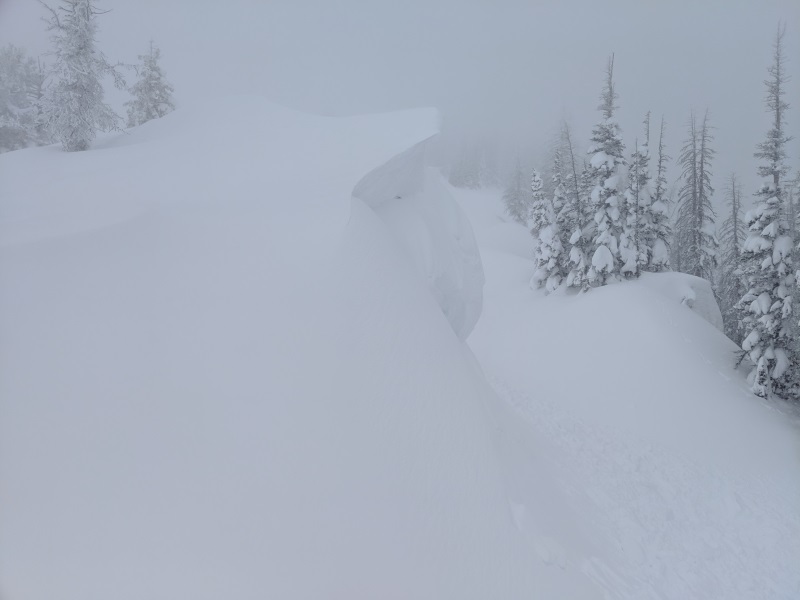
Third- steep, wind drifted terrain that didn't slide during last weeks big storm is particularly problematic, because today's avalanches could still potentially be triggered mid slope, low on the slope, or from a distance. All we need to do is collapse the slope (whoomph), and now we're staring down the barrel of a dangerous avalanche.
Lots of variables and a few, false "green light" indicators. So, the way we deal with a complicated snowpack is to simply avoid the unknowns. Now, here's what I do know and make no mistake... this is the real deal and not the type of avalanche problem that we want to tangle with or try to outsmart. Once initiated, today's avalanches can break deep and wide, taking out the entire seasons snowpack in some locations, resulting in a potentially unsurvivable slide.
That's too much uncertainty for me to deal with so I'm keeping it simple... patience and avoidance are the only solution. I'm simply gonna ride low angle, wind sheltered slopes and avoid being on or under steep, wind drifted slopes. Done... done.... and done!
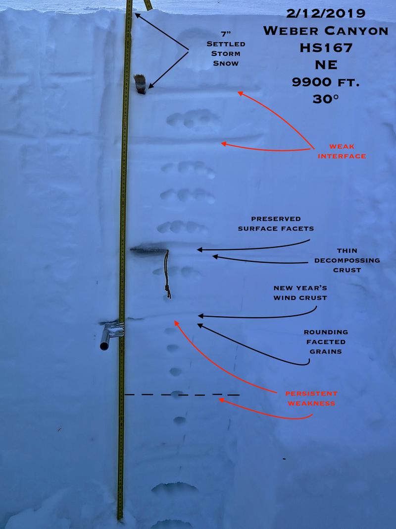
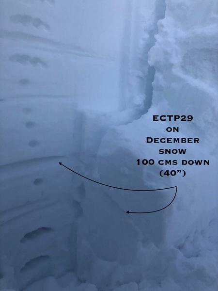
JG's snowpit profile clearly shows our current layering... perhaps getting slightly hard to trigger, but once you collapse the slope it's game over. Here JG brilliantly describes what he's seeing.... "You really get a false sense of security when you are walking, skiing or sledding on such a supportable snowpack. Based on recent avalanches, what I have been seeing in my travels and what I have been seeing in my snowpits I don't think we are close to being out of the water. It's hard to not want to jump into steep terrain when there aren't a lot of visual signs to make you take a step back. Dig in the snow and see for yourself. Just read about the recent tragedies and close calls, it's sobering. Low angle is plenty fun right now, have fun and live another day. The forecast has been spot on, heed the warnings, the Uintas are sketchy right now. "
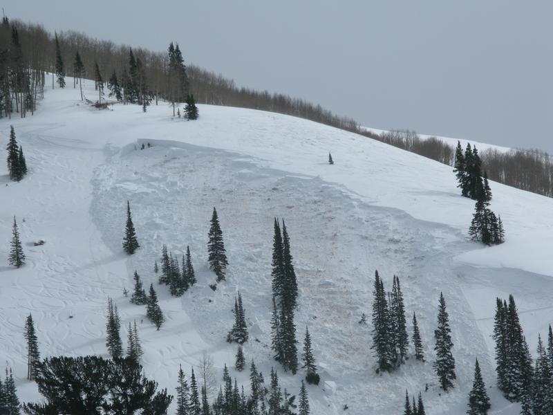
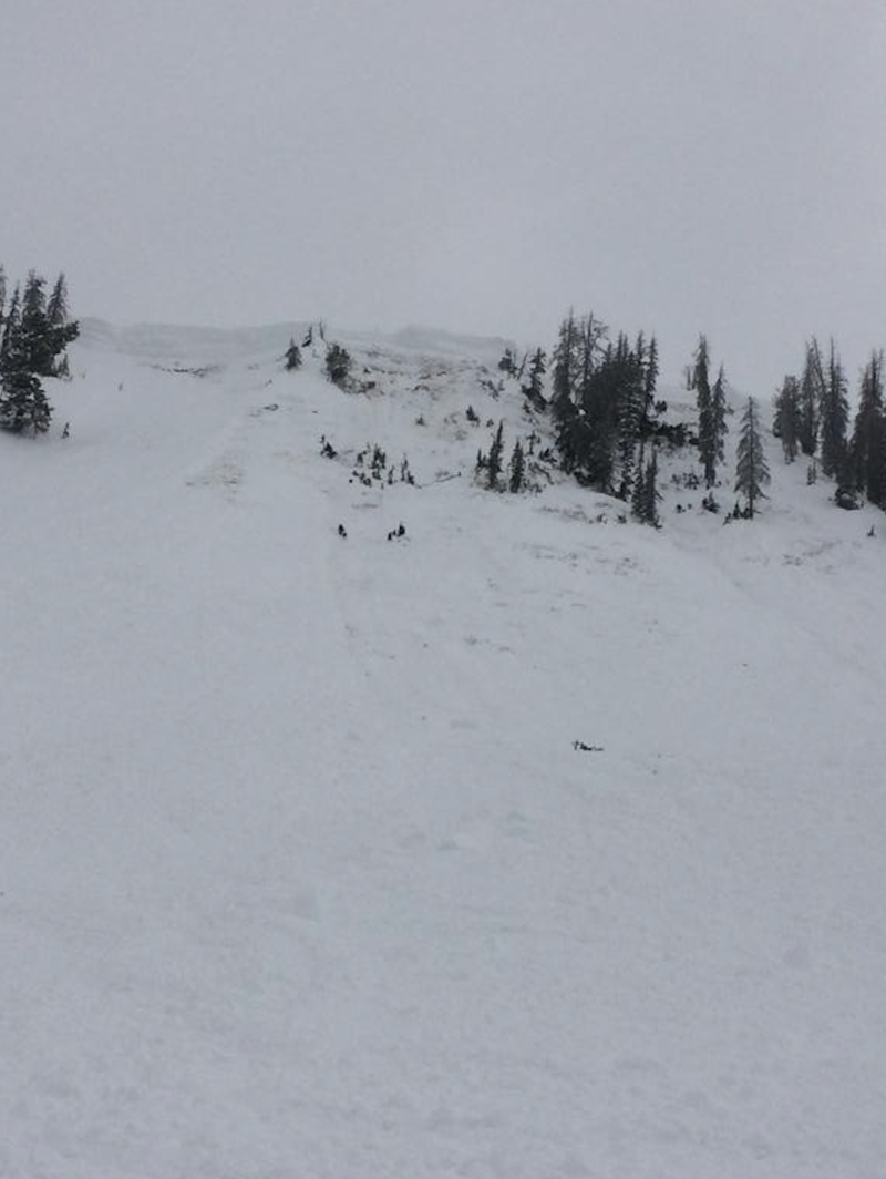
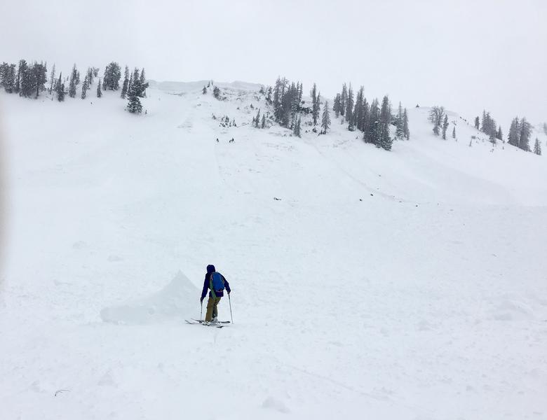
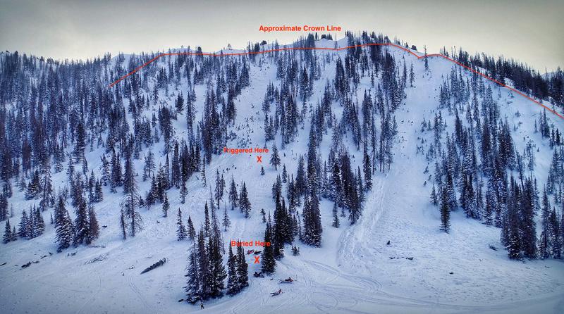
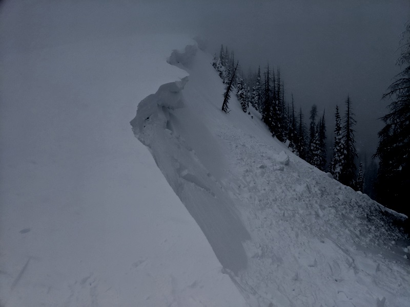
Snowpits are just a small sample size. What I look for is something I can sink my teeth into... like recent avalanche activity and the slide in the image above triggered in Upper Weber Canyon clearly sets the stage. Once initiated, this tree snapping slab, broke deep and wide, stacking up a huge pile of bone crushing debris.
Avalanche Problem #2
Wind Drifted Snow
Type
Location
Likelihood
Size
Description
Even more fresh wind slabs formed overnight, adding yet another layer, to another layer, to the last layer of wind drifted snow. Now our wind slabs involve multiple storms, so they're more connected, and may break deeper than we might anticipate. While most prevalent on the leeward side of mid and upper elevation ridges, drifting also occurred around terrain features like chutes, gullies, and sub-ridges. In addition, recent winds cranked even down low near the trailheads, so expect to find fresh drifts in unusually low elevation terrain. In any case, today you'll want to look for and avoid any fat, rounded piece of snow, especially if it sounds hollow like a drum.
A great observation by Michael J clearly showing winds have been busy at work not only forming thick wind drifts, but also creating large corni that may break back further than you might expect. More on Michael's travels here.
Avalanche Problem #3
Wet Snow
Type
Location
Likelihood
Size
Description
Dense, heavy snow at lower elevations will make the steep slopes above our mountain communities suspect. If you're going for a snowshoe, trail-run, family outing, or dog walk you'll want to steer clear of steep, snow covered slopes and avoid terrain traps like gullies and road cuts where even a small slide can pile up big piles of cement-like debris.
Additional Information
A break in the action is on tap this morning, but it'll be short-lived as the next round of snow is upstream and poised to slide through the region later today and tonight. In the meantime, expect temperatures to rise into the 30's and increasing southerly winds, gusting into the 40's and 50's by about dinnertime. A strong cold front slams into the region late today and tonight, delivering a solid shot of snow with about a foot expected by this time Saturday morning.
General Announcements
The information in this advisory expires 24 hours after the date and time posted, but will be updated by 7:00 AM Saturday February 16th, 2019.
If you're getting out and about, please let me know what you're seeing especially if you see or trigger and avalanche. I can be reached at [email protected] or 801-231-2170
It's also a good time to set up one of our very popular avalanche awareness classes. Reach out to me and I'll make it happen.
This information does not apply to developed ski areas or highways where avalanche control is normally done. This advisory is from the U.S.D.A. Forest Service, which is solely responsible for its content. This advisory describes general avalanche conditions and local variations always occur.