UDOT PLANNED AVALANCHE CLOSURES!!

Forecast for the Uintas Area Mountains

Craig Gordon
Issued by Craig Gordon for
Tuesday, February 14, 2023
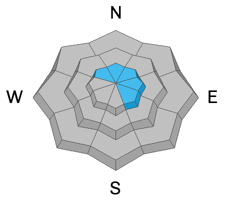
Roses are... a light shade of yellow in the western Uinta's-
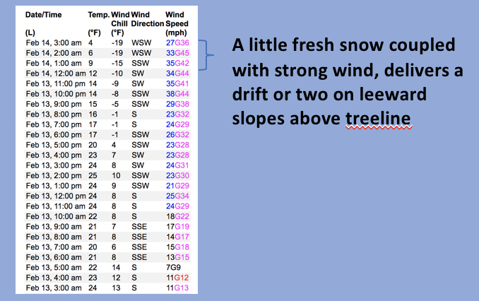
In a sea of green, pockets of MODERATE avalanche danger are found on leeward slopes above treeline. While hardly big enough to boss you around, but might surprise you none-the-less, a rogue wind drift or two will react to our additional weight. Human triggered avalanches are POSSIBLE, especially on steep slopes in the wind zone facing the north half of the compass. Lose the wind and you lose the problem. LOW avalanche danger is found around the dial in mid and low elevation wind sheltered terrain where human triggered avalanches are UNLIKELY.
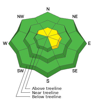
Low
Moderate
Considerable
High
Extreme
Learn how to read the forecast here
Weather and Snow
Nowcast- A band of moisture still tries to produce a few inches of snow for the Uinta's, but so far has only delivered a couple traces. Cold air definitely filtered into the region in the past few hours as the mercury dips into the single digits near the ridges and teens at the trailheads. The storm is a bit of a bust, but if you ordered west and southwest wind, well then, we've got ya covered, especially near the high peaks where winds steadily blow in the 30's and 40's. It's gonna be a bit rugged this morning and your best best for soft snow is mid elevation, wind sheltered terrain.
Forecast- Look for scattered snow showers with an inch or so stacking up, along with cold temperatures, not straying much from where we're at this morning. Westerly winds are gonna be obnoxious, blowing in the 40's for the next few hours, but taper off later this morning and switch to the north and then northeast. Expect scattered snow showers tonight with temperatures cratering into negative territory.
Futurecast- Not much action in the weather department to round out the work week, but there's some buzz circulating around a storm materializing late in the weekend. I'll keep ya updated as details evolve.

I know you came for the snow, but I hope you'll stay for the views... Hayden Peak looking mighty whitey these days :)
John Climaco was in Blacks Fork Sunday and reports excellent coverage and riding.
On Saturday, Ted cruised into Moffit Basin, while Micheal J stomped around Smith-Moorehouse, and I slid through Upper Chalk Creek.
Huge thanks for all the great obs streaming in from the eastern front. Even more detailed trip reports and recent obs are found HERE.
Recent Avalanches
No significant avalanche activity to report, but if ya wanna geek out, click HERE to track this years slide activity throughout the range.
Ad
Avalanche Problem #1
Normal Caution
Type
Location
Likelihood
Size
Description
A 24 hour data dump from Windy Peak (10,662') shows the trend of recent winds.
Last night winds conspire with a little fresh snow to form a shallow wind drift or two on the leeward side of upper elevation ridges in the wind zone. Not widespread and confined mostly to upper elevation terrain, today you'll wanna be on the lookout for and avoid fat, rounded pieces of snow, especially if they sound hollow like a drum. You know the program... lose the wind and you lose the problem.

Additional Information
Weather stations-
And... rime events have severely crippled the Uinta weather station network. I'm working to get it back up and running, but a few stations are found HERE (click weather stations, and then on the Western Uinta tab)
Observations-
Your observations are important, so please let me know what you're seeing... click HERE and contribute to this amazing community-based program
General Announcements
Issued at 03:02 on Tuesday February 14th, this forecast expires 24 hours after the date and time posted, but will be updated by 07:00 Wedesday February 15th 2023.
Before it gets too crazy, now is the time to book an avalanche awareness presentation for your group, club, or posse. You can reach Craig directly at 801-231-2170 or [email protected].

This forecast is from the U.S.D.A. Forest Service, which is solely responsible for its content. This forecast describes general avalanche conditions and local variations always occur.