March Kicks Off Our Spring Campaign- Donate Now to Support Forecasting

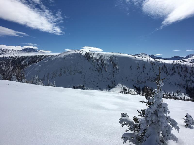
Forecast for the Uintas Area Mountains

Craig Gordon
Issued by Craig Gordon on
Friday morning, February 14, 2020
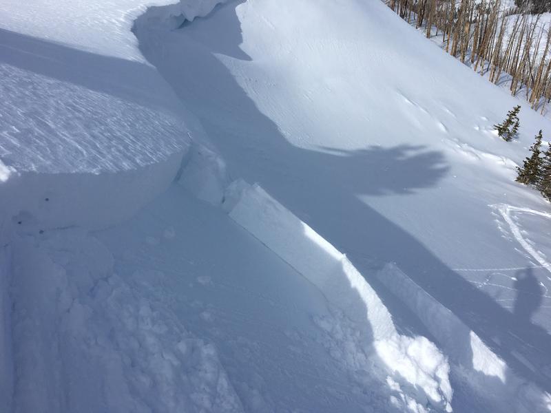
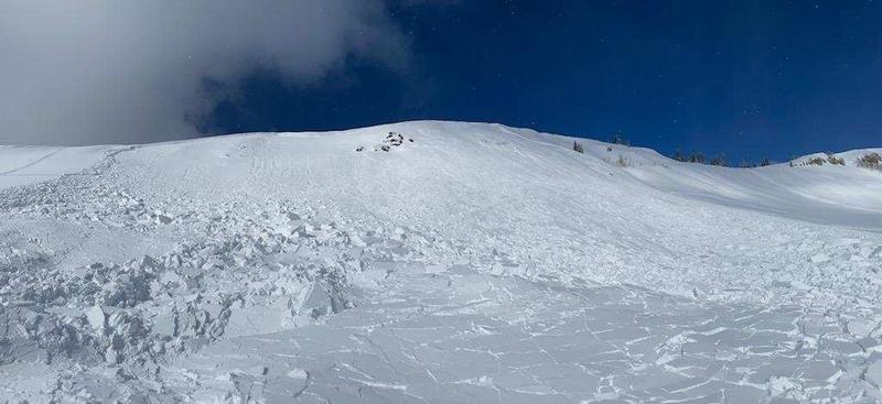
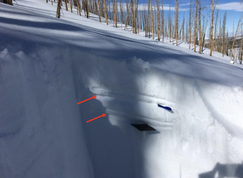
In a sea of LOW avalanche danger, you could still trigger a slide that breaks deeper and wider than you might expect and here's what to look for-
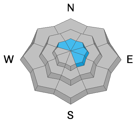
While more the exception than the rule, in the wind zone, at and above treeline, pockets of MODERATE avalanche danger exist. Human triggered avalanches are POSSIBLE on steep, wind drifted slopes. Avalanches breaking into deeper, buried weak layers remains a distinct possibility. Usual suspects include- steep, rocky, upper elevation terrain, especially slopes exhibiting a thin, shallow snowpack. Remember- any slide that breaks to old snow, instantly throws a curve ball at your day.
Lose the wind and you lose the problem. Wind sheltered mid and low elevation terrain offers generally LOW avalanche danger.
Low
Moderate
Considerable
High
Extreme
Learn how to read the forecast here
Weather and Snow
Currently-
Under clear skies, temperatures are in the mid teens, nearly 10 degrees warmer than yesterday at this time. Right around 1:00 this morning south and southwest winds bumped into the 20's and 30's along the high peaks. On a go anywhere base, the pack is deep with average snow depths clocking in right around five feet. And while there's some wind funk and suncrusts out there, the vast majority of our terrain offers excellent riding right now, especially wind sheltered, mid elevation slopes.
Uinta weather network info is found here. Simply click on the Western Uinta tab.
For today-
Look for increasing clouds throughout the day as yet another cold, albeit dry front slides through the region late in the day. High temperatures reach into the 30's with overnight lows in the teens. Westerly winds bump into the 30's and 40's as the day progresses.
Futurecast-
Periods of snow develop late Saturday night through Sunday. A cold front pushes through the area Sunday night bringing a burst of heavier snowfall, with a cold airmass lingering into early next week.
Ted was in Millcreek yesterday and reports a fat, white, and mostly stable snowpack. A great trip report from the guy who knows the Uinta's better than anyone is found here.
Recent Avalanches
No significant avalanche activity to report.
To view trip reports and recent avalanche activity, simply click here.
Ad
Avalanche Problem #1
Wind Drifted Snow
Type
Location
Likelihood
Size
Description
Not particularly widespread or connected, today you'll find pockets of wind drifted snow on steep, leeward slopes in the wind zone.
While last nights bump in westerly winds for a few hours may not look like much on the surface, I always need to remind myself the Uinta's are a huge range and I bet if you went looking to trigger a fresh wind slab.... you could find it. So, if you're getting into steep, technical terrain today, think about the consequences of triggering even a small slide that could boss you around and lead to an unintended outcome like getting slammed into a tree.
So the best rule of thumb is to simply avoid steep, wind drifted slopes, especially if they look fat and rounded or feel hollow and sound like a drum.
Avalanche Problem #2
Persistent Weak Layer
Type
Location
Likelihood
Size
Description
We can't see weak layers in the snowpack unless we take a minute, get our shovels out, and investigate... but the snowpack has an amazing memory and doesn't forget where these deficits are located. All we need to do is find one inconsistency (such a shallow, rocky section of the slope like in the image above), collapse the pack, and now we're staring down the barrel of a dangerous avalanche.
Most terrain offers a deep snowpack and it's happy in its own skin. Now I need to think about suspect terrain I want to avoid, and that includes steep, rocky terrain and slopes that avalanched near the ground earlier in the season. Recent avalanche activity involving weak snowpack structure confirms this hypothesis.
Additional Information
While hit or miss in distribution, a couple of rime crusts offering differant degrees of thickness and strength exist in our snowpack. Small grained facets are developing above and below these layers and it's worth tracking this development, especially with a storm on tap for late in the weekend.
General Announcements
The information in this forecast expires in 24 hours, but will be updated by 7:00 AM Saturday Feb. 15th.
This forecast is updated daily by 7:00 AM.
In the mean-time, if you see or trigger an avalanche or just wanna let me know what you're seeing you can reach me directly at 801-231-2170
This is a great time of year to schedule one of our free avy awareness presentations.
You can email me directly [email protected]
The information in this forecast is from the US Forest Service which is solely responsible for its content.