Forecast for the Uintas Area Mountains

Craig Gordon
Issued by Craig Gordon for
Wednesday, December 8, 2021
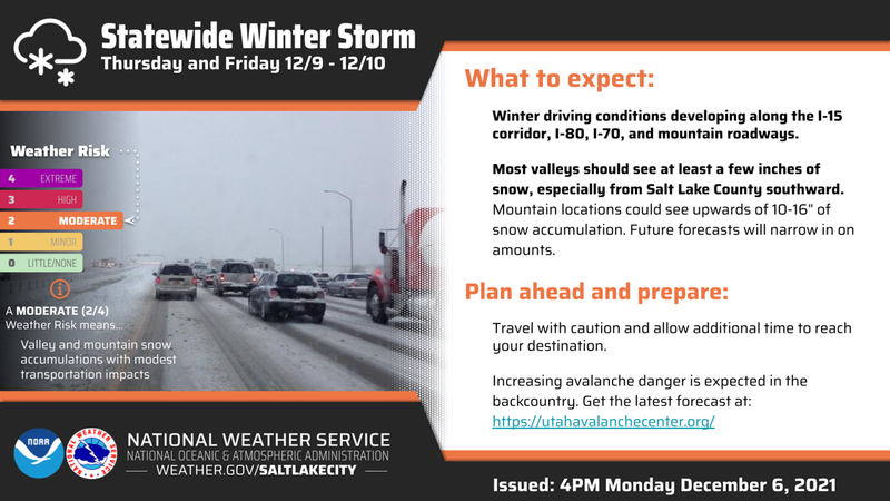
Heads up... avalanche conditions begin changing tonight as robust looking storm materializes through Friday. In the meantime though, there's just barely enough snow to move around on and you'd really have to go out of your way to trigger a slide. However, it's not out of the question as recent strong winds created stiff drifts on the leeward side of the highest terrain which may react to our additional weight. And remember... even a small avalanche this time of year will reveal a myriad of season ending obstacles. So, if you're hiking, hunting, snowshoeing or out for a high elevation peak bagging circuit you'll want to look for and avoid any steep, wind drifted slope.
Low
Moderate
Considerable
High
Extreme
Learn how to read the forecast here
Special Announcements
Huge thanks to Young Powersports of Bountiful for their continued partnership and support this year by providing two sweet loaner sleds to the UAC this winter. Their commitment to avalanche forecasting, outreach, and education is unparalleled and we deeply appreciate their support.
Also... it's Avalanche Week and there's a ton of great events going on throughout the state. Click HERE to find something near you!
Weather and Snow
NOWCAST-
Partly cloudy skies are short-lived today, as a good looking storm is on the doorstep, rolling into the region as the day progresses. In the meantime, temperatures are in the teens and low 20's. After a relatively calm night, southwest winds are just starting to bump into the mid 20's. Riding and turning options are a bit on the bleak side and limited to road rides and rock free, low angle meadows.
FORECAST-
Clouds thicken throughout the day, temperatures climb into the low 30's, and southwest winds ramp into the 40's as the day wares on. Snow is on the way and begins flying in earnest after about midnight.
FUTURECAST-
The main event kicks in early Thursday with a foot of snow a good bet by the time things wind down on Saturday.
Looking for real-time temps, snow, or wind?
Click HERE and then on the "western Uinta" tab for western Uinta specific, weather station network.
As the seasons change, we're interested in what you're seeing. Go here to fill out an observation.
Recent Avalanches
No recent avalanche activity to report, but Ryan Shea visited Murdock Bowl yesterday and submitted his snowpit profile with the comment, "Pit showed many layers of faceted snow and crusts, none of which were reactive in tests... skin and boot up showed mostly faceted snow from the ground up with some layers of harder snow, all of which could be penetrated to the ground during booting and made skinning a bit more difficult." Ryan's take on the snowpack and outstanding observation is found HERE.
Observations, trip reports, and avalanches found here.
Ad
Avalanche Problem #1
Wind Drifted Snow
Type
Location
Likelihood
Size
Description
Recent field trips and observations confirm our suspicions, the endless string of clear, cool nights has outdone any warmth and healing during the day. Unfortunately, the snowpack is taking a hard hit. In fact, on some high elevation shady slopes, the snow has grown so weak and sugary just moving around on it offers a challenge unto itself... sorta like wallowing in a sandbox. Not a problem now, but once it starts snowing again... heads up!
Today's avy danger is pretty straight-forward and you'd really have to go out of your way to trigger a slide. The bad news is... even a small wind drift along the leeward side of an upper elevation ridge can easily knock you off your feet and take you for a nasty ride through rocks, deadfall, or stumps.
And remember- just 'cause you can see it from the road doesn't means it's good to go. Our high mountain passes dump us off in avalanche terrain. I think about early season roadside attractions like Murdock Bowl off the Mirror Lake Highway or Wolf Creek Bowl near highway 35 and Wolf Creek Pass. Easy grabs... right? Even though it might not seem like there's enough snow to avalanche, today you'll want to avoid any steep, wind drifted slope.
Additional Information
Your observations are important, so please let me know what you're seeing... click HERE and contribute to this amazing community based program
As part of Avalanche Awareness Week, please join author Ed Power and I tomorrow night at 6:00 in the PC Library for a presentation and readings from Dragons in the Snow.
General Announcements
The information in this forecast expires 24 hours after the day and time posted, but will be updated by 07:00 Friday December 9th.
Before it gets too crazy, now is the time to book an avalanche awareness presentation for your group, club, or posse. You can reach me directly at 801-231-2170 or [email protected]
This forecast is from the U.S.D.A. Forest Service, which is solely responsible for its content. This forecast describes general avalanche conditions and local variations always occur.