Forecast for the Uintas Area Mountains

Craig Gordon
Issued by Craig Gordon for
Friday, December 15, 2023
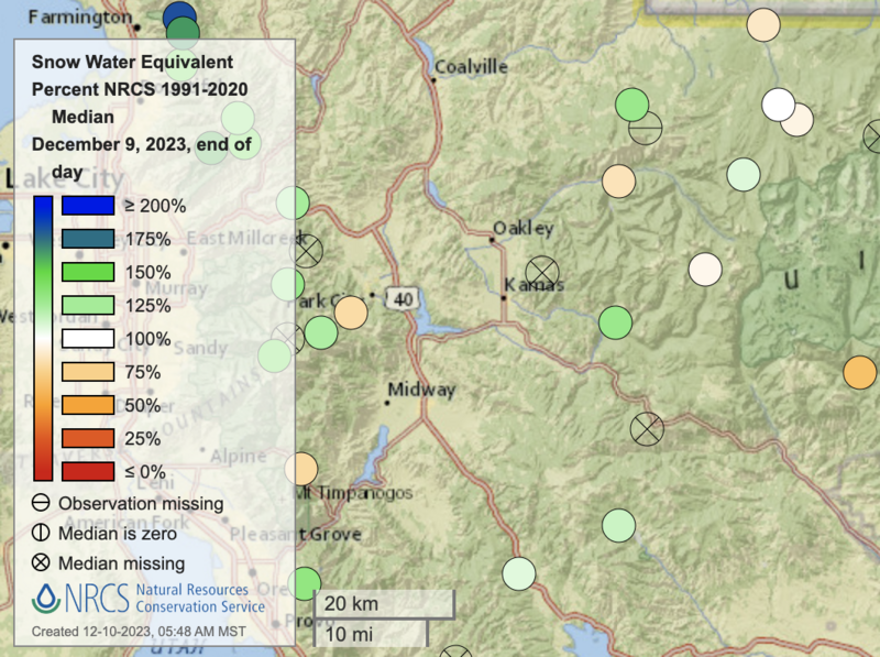
The good news is our snowpack is happy in its own skin and miles of terrain offer predictably, straight-forward avy danger-
A sea of green light conditions deliver generally LOW avalanche danger and human triggered avalanches are UNLIKELY. Yeah, you'd really have to go out of your way to trigger a slide. But... LOW danger isn't necessarily no danger, though just like a scene in the Soprano's, all the right players would have to come into play to deliver a Jersey Shakedown. Steep, rocky terrain in the windzone offering a shallow snowpack aligns with a cast of characters you don't wanna trust in a dark alley or in the mountains... either could throw an unexpected curve ball your way.

Low
Moderate
Considerable
High
Extreme
Learn how to read the forecast here
Special Announcements
Please join me for a current conditions, State of the Snowpack prezo at Inspired Summits HQ (8178 Gorgoza Pines Road) tonight, Friday at 6:00. Guaranteed to be informative, educational, and inside sources tell me... it'll be entertaining. Note... parrot sold separately :)
Weather and Snow
Nowcast- Skies are clear, whilst winds blow from the west and northwest at 10-15 mph, barely spinning the propellers at our ridgetop wind sites. Cold air pools at lower elevations and a slight temperature inversion allows the mercury to dip into the teens at the trailheads as mid 20's are the norm with elevation gain. Riding and turning conditions have taken a bit of a hit. Sunny slopes took on heat the past few days and offer variable conditions, while riding and turning conditions remain quite good on shady slopes where you'll find shallow, creamy pow.
Forecast- Expect severe clear as building high pressure homesteads overhead, delivering sunny skies, light winds, and temperatures climbing into the mid 30's.
Futurecast- No big weather pattern change until perhaps right around Christmas.

Even though it may seem like a slow start to the season, the snowpack is about average (scroll to the bottom of the forecast for more info). There are 3 basic layers in the snowpack (1) old snow from October and mainly November with a crust from mid-November, (2) snow from the warm, wet storm from the first weekend of December with a crust on top of it, and (3) snow from last Friday which favored the northern part of the Uintas.
Recent Avalanches
No significant avalanches to report for nearly a week. All Uinta avalanche activity is found HERE.

Snow-pros, Joey Manship and Andy Nassetta gathered a ton of info from Smith-Moorehouse Wednesday and have a most excellent trip report. I was in Upper Weber Canyon yesterday.
Trip reports and the latest observations are found HERE.
Ad
Avalanche Problem #1
Normal Caution
Type
Location
Likelihood
Size
Description
Here's the deal-
Snow... just like people, doesn't like rapid change. In fact, rapid change activates weak layers in the snowpack, makes 'em cranky, and brings 'em back to life. We know our pack has issues and it's structurally challenged, but it hasn't experienced a rapid change since last Friday's big storm gave it a solid thump. But overtime, the pack has adjusted, it's relaxed, and it's happy in its own skin. Sure the setup of strong snow resting on top of weak snow exists, but man, you'd really have to go out hunting for a slide.The good news is... we've got plenty of choices and there's miles of terrain to ride safely today.
Outlier terrain in the bulls-eye where you could get into trouble today includes, steep, rocky, wind drifted slopes in the wind zone. However, it feels like the right cast of characters would have to perfectly align to throw a wrench in your day.
Additional Information
Huge thanks to Rylan from Young Powersports for trusting me with the keys to the backcountry kingdom as well the keys to this 2023 Polaris. The decades old "loaner sled" partnership with Polaris allows me to see more terrain, issue more accurate forecasts, and ultimately saves lives! Note to self... always remember to grab the keys to the sled before leaving the dealer :)
While it seems like a slow start to the season, in terms of water amounts, SNOTEL sites in the Western Uintas generally have median values. White dots are at the median. Green are a little above, and beige dots are a little below. Click on the image for an interactive map from the NRCS.

We are always looking for snow and avalanche observations or just general riding conditions. So... if you see something, say something. You can reach me directly at [email protected] or 801-231-2170.
Also, if you're looking for more avy education opportunities for yourself, your crew, or your club please don't hesitate to reach out to me and we'll find a presentation, class, or clinic for ya!
General Announcements

Issued at 04:15 on Friday, December 15th this forecast will be updated by 0700 Saturday, December 16th, 2023.
This forecast is from the U.S.D.A. Forest Service, which is solely responsible for its content. This forecast describes general avalanche conditions and local variations always occur.