Forecast for the Uintas Area Mountains

Craig Gordon
Issued by Craig Gordon on
Saturday morning, January 9, 2021
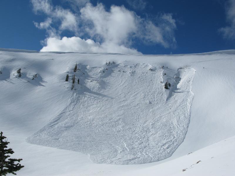
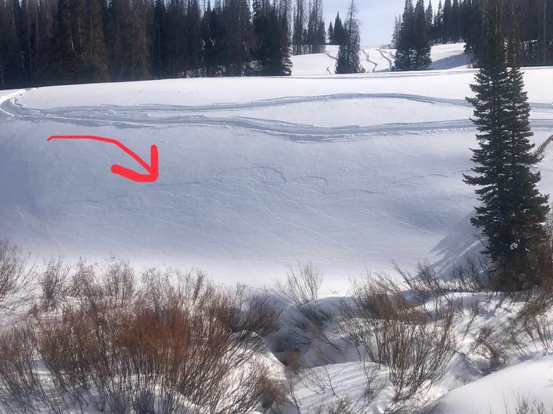
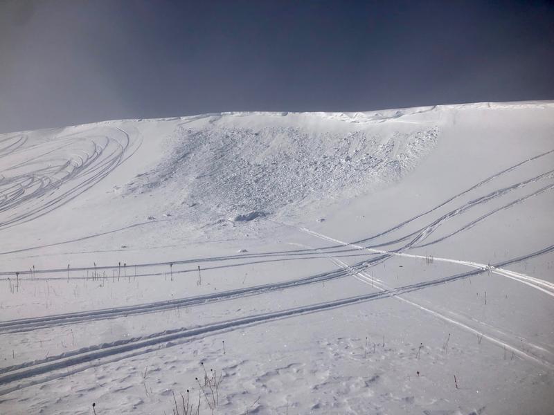
The western Uinta snowpack is deceptively tricky... once triggered, today's avalanches will break deeper and wider than you might expect, resulting in a dangerous slide with severe consequences.
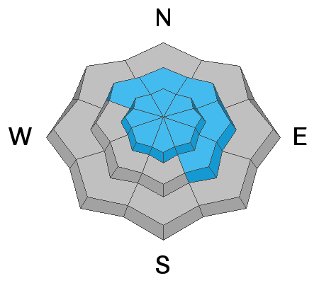
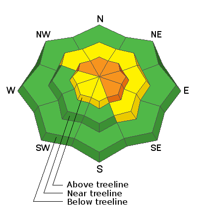
In the wind zone, at and above treeline, you'll find CONSIDERABLE avalanche danger. Human triggered avalanches are LIKELY on steep, wind drifted slopes. Steep terrain facing the north half of the compass, and particularly slopes with an easterly component to its aspect are most suspect and should be avoided.
Mid elevation slopes offer MODERATE avalanche danger and human triggered avalanches are POSSIBLE on steep, shady slopes.
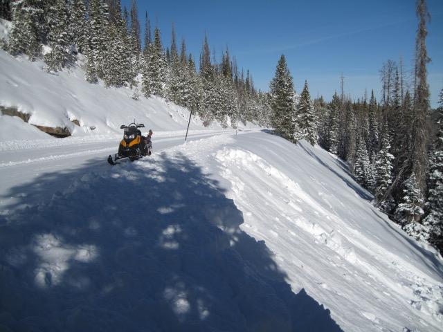
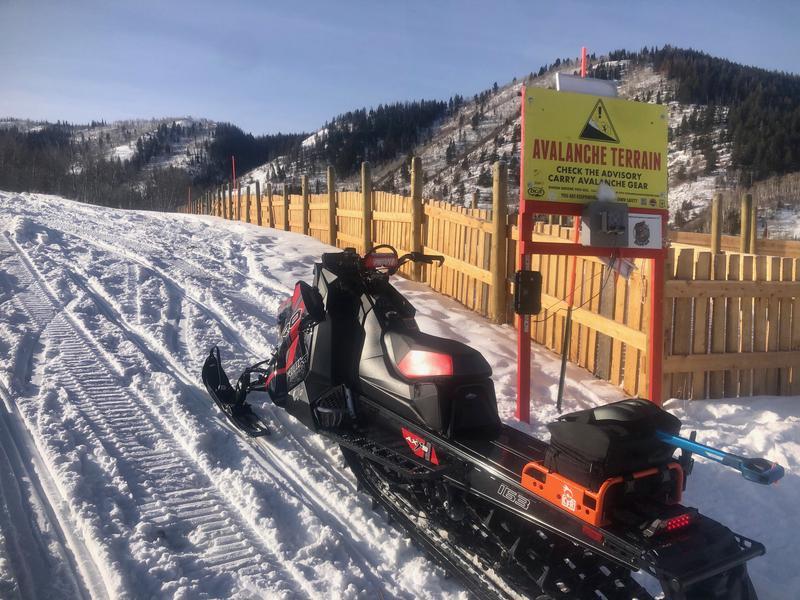
Here's your exit strategy-
LOW avalanche danger is found on low elevation slopes, particularly those facing south, but snow cover is super thin.
Low
Moderate
Considerable
High
Extreme
Learn how to read the forecast here
Special Announcements
With great sadness I report Utah's first avalanche accident of the season which occurred in the backcountry terrain of Dutch Draw yesterday. Our team, in partnership with Canyons Village ski patrol, is headed there this morning and will assist to investigate and report details as they become available. Of course, our hearts and collective energy go out to everyone involved, particularly to the friends and family of a 31 year old Clinton, Utah man who was tragically killed. A preliminary report is posted here.
Thanks to the generous support of our local resorts, Ski Utah, and Backcountry, discount lift tickets are now available. Support the UAC while you ski at the resorts this season. Tickets are available here.
Weather and Snow
Nowcast-
A weak storm sliding south of the region early this morning ushers in a few clouds and perhaps an inch or two of snow right around sunrise. Northwest winds blow 15-25 mph along the high ridges and temperatures are in the single digits. No recent new snow to report, but Tuesday's storm delivered a solid 10" of medium density snow and conditions look more encouraging out there as average snow depths creep into the three foot range. And while things slowly improve, it's still low tide in the Uinta's and travel is sorta limited to road rides and grassy slopes.
Forecast-
Expect mostly cloudy skies this morning with a few flurries. Skies clear as the day wares on and high temperatures climb into the upper 20's with overnight lows dipping into the single digits.
Futurecast-
High pressure builds into early next week with no big storms in sight.
Looking for real-time temps, snow, or wind?
Click here and then on the "western Uinta" tab for western Uinta specific, weather station network.
Recent Avalanches
From Thursday, this slide in Humpy Basin on an upper elevation northeast facing slope, was triggered lower downslope than you might expect. Breaking 18"-24" deep and 200' wide, in a steep rocky section where the snowpack is slightly shallower and weaker... this is the type of avalanche you could still trigger today.
Our main man, Ted Scroggin, took a rip around Mirror Lake Highway Wednesday and found plenty of signs of unstable snow including small avalanches just off the freshly groomed road. Ted knows the Uinta's better than anyone. His insight, trip report, and sage knowledge is found here.
Looking for more avy info and trip reports? Well then, simply click here.
Remember.... solid decision making is paramount because our front-line health care workers are maxed out. So, let's collectively think about our decisions and the consequences that may have on others.
Ad
Avalanche Problem #1
Persistent Weak Layer
Type
Location
Likelihood
Size
Description
The writing is on the wall and it's pretty clear we've got plenty of signs indicating the snowpack teeters on the edge. Booming collapses, shooting cracks, and the biggest sign of avalanches.... AVALANCHES!
So here's the deal- the snowpack is complex, we have a persistent weak layer in the mid portion of the pack, and this fragile structure experienced a rapid change earlier in the week when Tuesday's storm slammed down on it. Our snowpack needs a little time to get comfortable in its own skin.
Many slopes hang in the balance waiting for a trigger like us to roll along and knock the legs out from underneath. This is the setup where the wheels come off the bus because we can trigger slides from the flats, low on the slope, from a distance, or from adjacent slopes. We don't need to be on the slope... just connected to it.
This is the kind of avalanche dragon where we pull the entire log pile down on top of us, even if we're playing on low angle terrain.
But you don't have to ride blind... so, tweak small test slopes, looking for and listening to signs of unstable snow like whoomping sounds and sudden collapses of the snowpack or shooting cracks in front of your skis, board, or sled. And of course the biggest clue of all... recent avalanches, especially on the same types of slopes you wanna ride on.
Avalanche Problem #2
Wind Drifted Snow
Type
Location
Likelihood
Size
Description
Andy was on the south half of the range yesterday and took a look at this recent slide initiated by a natural cornice fall. His great trip report is found here
Recent wind drifts settled and gained strength the past few days and won't be quite as widespread or touchy today. But as we know, the Uinta's are a big place and a few lingering wind drifts may break deeper and wider than you might expect. The ticket is to avoid pulling on the dogs tail. Steer clear of steep wind drifted slopes and terrain features like chutes and gullies which appear fat and rounded or sound hollow like a drum. And remember... our snowpack is super shallow and triggering even a small slide can take you for a body-bruising ride through rocks and stumps barely hidden under the thin snowpack.
Additional Information
Andy Nassetta moved the avalanche transceiver checkpoint down to it's winter home at the Nobletts Trailhead. Please make sure to swing by and make sure your avy gear is on your body, sending a signal, and functioning properly
I'll update this forecast by 7:00 AM tomorrow, Sunday January 10th.
Your observations are import, so please let me know what you're seeing... click HERE and contribute to this amazing community based program
General Announcements
If you see or trigger an avalanche or just wanna let me know what you're seeing you can reach me directly at 801-231-2170 or [email protected]
The information in this forecast is from the US Forest Service which is solely responsible for its content.