UDOT PLANNED AVALANCHE CLOSURES!!

Forecast for the Uintas Area Mountains

Craig Gordon
Issued by Craig Gordon for
Monday, January 7, 2019
Heads up... it's gonna get real out there today.
The mountain landscape has changed and dangerous avalanche conditions exist.
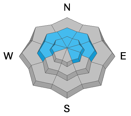
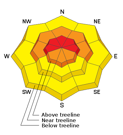
In the wind zone, at and above treeline the avalanche danger is HIGH. Human triggered avalanches are VERY LIKELY and natural avalanches LIKELY on steep slopes with recent deposits of wind drifted snow.
Any avalanche that breaks into deeper buried weak layers near the ground will result in a scary, dangerous, and possibly unsurvivable avalanche.
CONSIDERABLE avalanche danger is found on steep, wind drifted slopes at mid elevations, and human triggered avalanches are LIKELY, especially in terrain facing the north half of the compass.
Even low elevation terrain is getting in on the act where you'll find MODERATE avalanche danger on steep snow covered slopes.
If you're looking to ride today, simply head to big open meadows with no steep terrain above or connected to where you're traveling.
Low
Moderate
Considerable
High
Extreme
Learn how to read the forecast here
Avalanche Warning
THE FOREST SERVICE UTAH AVALANCHE CENTER IN SALT LAKE CITY HAS CONTINUED A BACKCOUNTRY AVALANCHE WARNING.
* TIMING...THROUGH 6 AM MST TUESDAY.
* AFFECTED AREA...FOR THE MOUNTAINS OF NORTHERN UTAH INCLUDING THE WASATCH RANGE, BEAR RIVER RANGE, AND UINTA MOUNTAINS.
* AVALANCHE DANGER...HIGH.
* REASON/IMPACTS...VERY DANGEROUS AVALANCHE CONDITIONS EXIST. HEAVY SNOW COMBINED WITH WIND WILL CREATE WIDESPREAD AREAS OF UNSTABLE SNOW. BOTH HUMAN TRIGGERED AND NATURAL AVALANCHES ARE LIKELY. STAY OFF OF AND OUT FROM UNDERNEATH SLOPES STEEPER THAN 30 DEGREES.
Weather and Snow
Wow... what a storm!
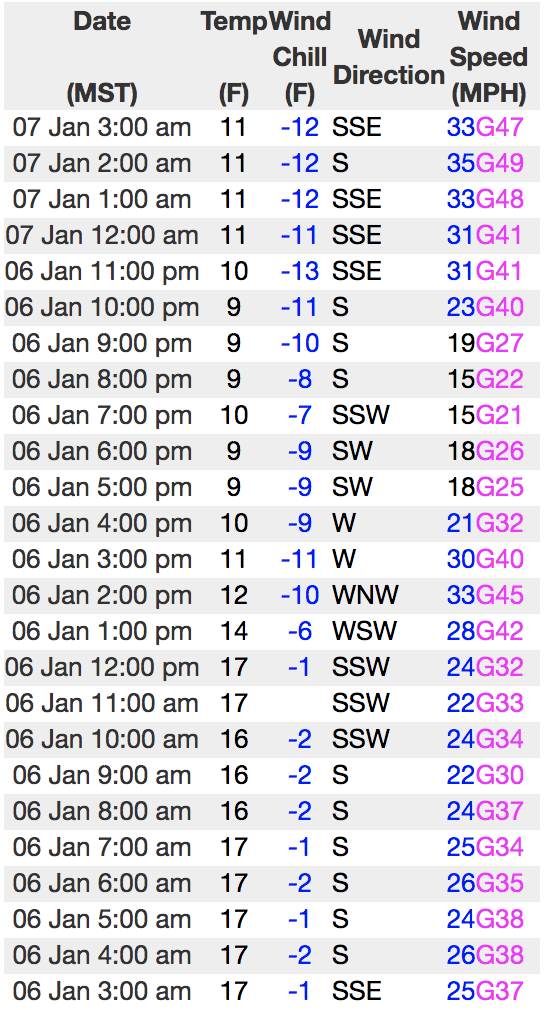
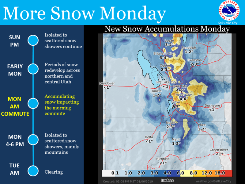
Heavy snow rapidly materialized yesterday morning, dumping just over a foot of light density snow in a matter of a few hours... but that was so yesterday. This morning there is yet another storm on our door step and southerly winds began ramping up around 9:00 last night and currently blow 30-50 mph along the ridges. It's gonna be rugged out there today, so if you are getting on the snow, low angle, wind sheltered terrain is the only place to be.
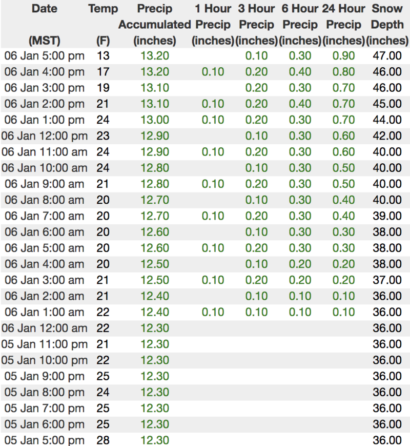
Above is hourly data until 5:00 pm Sunday from Trial Lake (9,945') along with recent wind data from Windy Peak (10,662'). To view more regional weather stations click here.
Recent Avalanches
Visibility was less than ideal yesterday, but I suspect the range experienced a natural avalanche cycle to some degree during the intense, midday snowfall.
Ad
Avalanche Problem #1
Wind Drifted Snow
Type
Location
Likelihood
Size
Description
Winds have been all over the place and there's no shortage of snow available to blow around and form fresh drifts that'll react to our additional weight. Found mostly along the leeward side of mid and upper elevation ridges, recent strong winds also cross-loaded snow around terrain features like chutes and gullies, and drifted snow lower downslope than we usually expect. In any case, fresh drifts are more widespread and more connected than yesterday, easily breaking deeper than you might expect. You're gonna have to be on your "A" game today, so look for cracking out in front of your skis, board, or sled which are obvious red flags and big clues to unstable snow. Also, avoid any fat, rounded piece of snow especially if it sounds hollow like a drum.
Avalanche Problem #2
Persistent Weak Layer
Type
Location
Likelihood
Size
Description
Today's strong winds coupled with dense, heavy snow will help bring dormant, persistent weak layers back to life, particularly in terrain where the snowpack is thin and weak. Remember- "persistent weak layers" in the snowpack are a headache because all we need to do is find one weakness, maybe around a bush or rock that we can't see buried underneath the snow, collapse the pack, and now we've triggered a deep, dangerous avalanche.
The usual suspects come to mind- steep, rocky terrain and slopes that have already avalanched this year. In addition, periphery terrain where the pack has remained shallow all season should be considered guilty until proven otherwise. Another wild card to add to the deck is the possibility of triggering an avalanche low on the slope or even from a distance.
Avoidance is the name of the game today.... simply avoid being on or under steep wind drifted slopes.
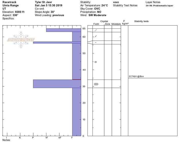
Above... a viddy from late last week along a pit profile from the south half of the range illustrating a suspect snowpack structure. The big red flag I see is periphery terrain that remains shallow and weak as shown by the structure in areas like Race Track Bowl. Thanks to Tyler St.Joer for the solid ob and info. More on his travels from yesterday here.
Additional Information
West and southwest winds crank into the 50's and 60's, gusting into the 80's along the high peaks, ahead of the next disturbance which will deliver an additional 4"-8" of snow. Winds gradually decrease this afternoon through tonight. High temperatures reach into the upper 20's with overnight lows in the teens. Snow tapers off tonight as a warm front moves through. Significant warming is anticipated through mid-week.
General Announcements
The information in this advisory expires 24 hours after the date and time posted, but will be updated by 7:00 AM Tuesday January 8th, 2019.
If you're getting out and about, please let me know what you're seeing especially if you see or trigger and avalanche. I can be reached at [email protected] or 801-231-2170
It's also a good time to set up one of our very popular avalanche awareness classes. Reach out to me and I'll make it happen.
This information does not apply to developed ski areas or highways where avalanche control is normally done. This advisory is from the U.S.D.A. Forest Service, which is solely responsible for its content. This advisory describes general avalanche conditions and local variations always occur.