Forecast for the Uintas Area Mountains

Craig Gordon
Issued by Craig Gordon for
Saturday, January 5, 2019
Heads up-
The avalanche danger will change overnight, ramping up during the day Sunday as a forecast storm begins to materialize.
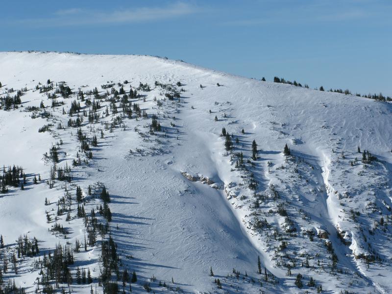
For today, while not widespread and making up a small portion of the terrain available to ride, in the wind zone, at and above treeline the avalanche danger is MODERATE. Human triggered avalanches are possible on steep slopes with recent deposits of wind drifted snow. Also... while more the exception than the rule and more pronounced in upper elevation terrain and on slopes with a thin snowpack, an avalanche triggered in steep, rocky terrain has the potential to quickly get out of hand if it breaks into deeper buried weak layers near the ground.
If you're looking for LOW avalanche danger, simply head to wind sheltered slopes with no steep terrain above or connected to where you're riding.
Low
Moderate
Considerable
High
Extreme
Learn how to read the forecast here
Weather and Snow
Above the valley funk, gunk, and cold, damp temperatures the mountain air is clear and temperatures hover in the mid 20's.... several warmer than in the City of Salt. Southerly winds bumped into the 30 and 40 mph range and have been blowing steadily for about 24 hours along the high peaks. Riding and turning conditions are a mixed bag. The New Years Eve winds punished our big, open terrain, transforming many slopes into a wind sculpted tundra. However, don't let your heart be troubled.... lose some elevation, head to wind sheltered terrain, and you'll be rewarded with cold, shallow, pow.
Above is recent hourly data from Upper Moffit Basin (9,126') along with wind data from Windy Peak (10,662'). To view more regional weather stations click here.
On Thursday, a weather station project on Lofty Lake Peak with my colleagues Mark Staples and Ted Scroggin provided great comradery, a taste of the snowpack structure, along with some spectacular views.
Recent Avalanches
No news of any significant avalanche activity.
Ad
Avalanche Problem #1
Wind Drifted Snow
Type
Location
Likelihood
Size
Description
I think the vast majority of wind drifts created earlier in the week are either welded in place or lack energy and are lifeless. But remember- the Uinta's are a big place and there may still be a rogue slab or two lurking along the leeward side of upper elevation ridges or even cross-loaded around terrain features like chutes and gully walls. However, with a good looking storm and a nice shot of moisture on tap, the avalanche danger will change overnight and I expect widespread drifting by this time Sunday morning. As the storm materializes, look for and avoid any fat, rounded piece of snow especially if it sounds hollow like a drum. Remember- cracking out in front of your skis, board, or sled are big red flags to unstable snow.
Chutes and gullies, complex and cross-loaded... the image above illustrates plenty of terrain features where recent winds cross-loaded terrain features, creating pockets of stiff wind drifted snow that may still be reactive to our additional weight.
Avalanche Problem #2
Persistent Weak Layer
Type
Location
Likelihood
Size
Description
It feels like we're trending towards a stronger snowpack and there's not much going on in the zones where the pack is deep. As a matter of fact, in most terrain our snowpack is in a state of equilibrium and happy in it's own skin. Here's the wild card..."persistent weak layers" in the snowpack are a headache because all we need to do is find one weakness, maybe around a bush or rock that we can't see buried underneath the snow, collapse the pack, and now we're getting worked by a large piece of moving of snow. The usual suspect terrain comes to mind- steep, rocky slopes with a shallow snowpack, along with periphery terrain which harbors a thin, weak snowpack, and slopes that already avalanched earlier this year. So the way I'm avoiding this scenario is by simply avoiding the terrain where this setup exists.
Looking into the future and with a storm on the horizon, we'll have to see how snow, water, and winds stack up, but I expect our days of dormancy are short-lived and the pack comes back to life.
Above... both a viddy and snowpit describing what we saw in our upper elevation travels yesterday around the Mirror Lake environs.
Additional Information
Today we can expect increasing high clouds with temperatures climbing into the low and mid 40's. Southwest winds increase along the high ridges, blowing into the 40's throughout the day, cranking into the 60's and 70's overnight. Snow develops this evening and a quick burst of moisture stacks up 3"-6" of snow by Sunday morning. The flow turns more westerly and weakens late tomorrow morning or midday with accumulating snow continuing through the afternoon hours. A break in the weather Sunday evening with snow developing again late Sunday night into Monday.
General Announcements
The information in this advisory expires 24 hours after the date and time posted, but will be updated by 7:00 AM Sunday January 6th, 2019.
If you're getting out and about, please let me know what you're seeing especially if you see or trigger and avalanche. I can be reached at [email protected] or 801-231-2170
It's also a good time to set up one of our very popular avalanche awareness classes. Reach out to me and I'll make it happen.
This information does not apply to developed ski areas or highways where avalanche control is normally done. This advisory is from the U.S.D.A. Forest Service, which is solely responsible for its content. This advisory describes general avalanche conditions and local variations always occur.