Forecast for the Uintas Area Mountains

Craig Gordon
Issued by Craig Gordon on
Friday morning, January 30, 2026

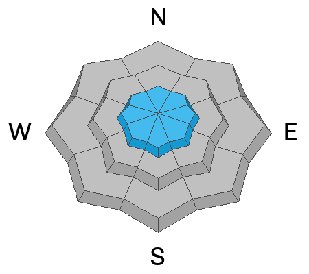
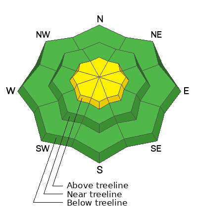
In the windzone at and above treeline, you'll find pockets of MODERATE avalanche danger on steep, leeward slopes around the compass. Human triggered wind drifts, breaking up to a foot deep are POSSIBLE, particularly in terrain with an easterly component to its aspect.

Don't forget... today's drifts rest atop a variety of old snow surfaces, including sugary facets and slick crusts, and once initiated, may break a bit deeper and wider than you might expect.
Low
Moderate
Considerable
High
Extreme
Learn how to read the forecast here
Weather and Snow

Nowcast - Wax on.... wax off... with clear skies overhead a big, beautiful, waxing Snow Moon cast amazing light on the Uinta Range. Winds near the high peaks blow 10-20 mph from the northwest, while thermometers, looking forward to the weekend, wrap up their graveyard shift in the mid teens °F.

Forecast - Expect mostly sunny skies, light northerly winds, and high temperatures climbing into the mid 30's °F. Overnight lows dip into the low 20's °F, or if you're like me and more in the William Thomason/Kelvin camp an easy conversation in your head suggests 266.483 °K.

Futurecast - A dry northwest flow maintains light winds blowing from the north and northwest, along with mostly sunny skies, and temperatures warming into the low 40's for the weekend Tofurky barbecue. Monday ushers in an underwhelming storm with high pressure quickly building thereafter. Significant storminess holds off 'til about Valentines Day.

Travel Conditions -

Wednesday's couple inches of snow coupled with bright sunshine went a long with to improve the snow surface and bumped morale upward by a notch or three :)

Recent Avalanches

Stomping around in North Slope Environs yesterday, I found shallow, yet very reactive NSF sluffs and facet-lanches.

Avalanche Problem #1
Wind Drifted Snow
Type
Location
Likelihood
Size
Description

Not much wind in the past 24 hours, though the Uinta's are huge place and I bet there's a shallow, rogue drift that could catch my attention. Found mostly on the leeward side of ridges, it wouldn't surprise me to encounter a rounded, fat piece of snow reactive to my additional weight on a cross-loaded terrain feature like a chute or gully wall. So, I remind myself... even a small slide in consequential terrain could ruin my winter season if it strains me through rocks, cliffs, or trees.

Fortunately, we can steer clear of this problem today... lose the wind and you lose the problem. Simply lose some elevation and hone in on wind sheltered terrain. In addition, look for and avoid fat, rounded pillows of snow, particularly if they look textured or sound hollow like a drum. And finally, stomp around on small test slopes like road cuts similar to what you wanna ride and see how they're reacting before pulling the trigger on a big slope.

General Announcements

We have some upcoming classes and events that we'd be stoked to see you at -- Please reach out with any questions and check out below for more details!

We are always looking for snow and avalanche observations or just general riding conditions. Reach out to us with questions, concerns, or if you see anything in your travels! Contact us directly through the info below:

This forecast is from the U.S.D.A. Forest Service, which is solely responsible for its content. This forecast describes general avalanche conditions, and local variations always occur. This forecast was issued on Friday, January 30th at 0300 AM and expires 24 hours after it was issued. We'll update this information by 07:00 AM tomorrow