UDOT PLANNED AVALANCHE CLOSURES!!

Forecast for the Uintas Area Mountains

Craig Gordon
Issued by Craig Gordon for
Sunday, January 22, 2023
Still rather predictable-
MODERATE avalanche danger is found on steep, upper elevation leeward slopes, especially in the wind zone at and above treeline. Fresh wind drifts reactive to our additional weight are POSSIBLE, particularly on slopes facing the south half of the compass.
Generally LOW avalanche danger is found on all mid and lower elevation slopes.

Low
Moderate
Considerable
High
Extreme
Learn how to read the forecast here
Special Announcements
Are you snowpack curious... wondering how the Persistent Weak Layer went from Zero to Hero? Well then, you came to the right place! Please join me 6:00 Monday, January 23rd in Park City at the Kimball Junction Library for a State of the Snowpack prezo. It's gonna be informative, educational, and quite possibly entertaining :)
Weather and Snow
Nowcast- A storm is headed our way, but it's still churning along and currently visiting Northern Nevada. While we wait... skies are clear and temperatures start off the work day hovering right around zero. Westerly winds blow in the 20's near the high peaks and are a cold, waste of weather, kinda nuisance. In fact, recent winds worked our big, open alpine terrain, but lose some elevation, seek out wind sheltered terrain, and you'll be rewarded with soft, creamy snow.
Forecast- Good news for all the wind lovers in the room... there's more wind on the way! Strong northwest winds gusting into the 40's usher in our next shot of snow which arrives around 08:00 and delivers 2"-4" of snow. High temperatures barely crawl out of the deep freeze and overnight lows dip into negative territory.
Futurecast- Clear and cold for Monday.

Not exactly Mavericks, but that's ok.. I found some legit tube time yesterday none-the-less.
Ted was near Whiskey Creek yesterday taking advantage of outstanding riding conditions. His take on things found HERE.
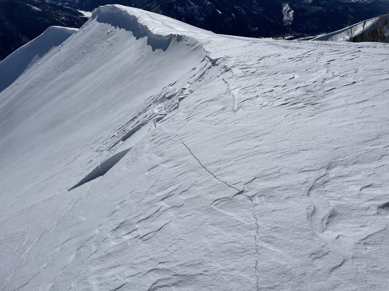
Also, I'm super stoked to see Trevor Katz great ob and insight from the south half of the range near Tut Creek. Nice work man... thanks for the beta!
Huge thanks for all the great obs streaming in from the eastern front. Detailed trip reports and recent obs are found HERE.
Recent Avalanches
Yesterday, I found a shallow wind drift or two in the north half of the range, while John Climaco found similar wind loading patterns on the south half of the range near Currant Creek. No other significant avy activity to report. But a slew of Uinta avy obs are found HERE.
Snow-Pro, mentor to countless avalanche professionals, all around amazing person, and always keen to rally... Bill Nalli, has a keen eye for all things avalanche and spotted a rather significant, week old slide in Upper Moffit Basin. Deets are found HERE.
Ad
Avalanche Problem #1
Wind Drifted Snow
Type
Location
Likelihood
Size
Description
In the wind zone... a shallow wind drift on a steep leeward slope in the image above is overshadowed by a huge cornice in the distance. Both easy to avoid because... if the thunder don't get you then the lightning will.
There's no shortage of snow available to blow around and recent winds have no problem whipping up a fresh round of shallow drifts sensitive to our additional weight. Found on upper elevation leeward slopes all over the compass, they're manageable in size and manageable by avoidance... lose a little elevation, you lose the wind and you lose the problem.

Additional Information
Come as you are or grab your black tie... in either case I'd like to visit with you Monday night :)
Colossal water numbers and Herculean snowpack depths are helping the pack turn the corner. This strongly aligns with reasoning to pull the plug on our problem child, the Persistent Weak Layer, which has plagued us since late November... whew!
Weather stations-
And... rime events have severely crippled the Uinta weather station network. I'm working to get it back up and running, but a few stations are found HERE (click weather stations, and then on the Western Uinta tab)
Observations-
Your observations are important, so please let me know what you're seeing... click HERE and contribute to this amazing community-based program
General Announcements
Issued at 03:33 on Saturday January 22nd, this forecast expires 24 hours after the date and time posted, but will be updated by 07:00 Monday January 23rd, 2023.
Before it gets too crazy, now is the time to book an avalanche awareness presentation for your group, club, or posse. You can reach Craig directly at 801-231-2170 or [email protected].

This forecast is from the U.S.D.A. Forest Service, which is solely responsible for its content. This forecast describes general avalanche conditions and local variations always occur.