March Kicks Off Our Spring Campaign- Donate Now to Support Forecasting

Forecast for the Uintas Area Mountains

Craig Gordon
Issued by Craig Gordon on
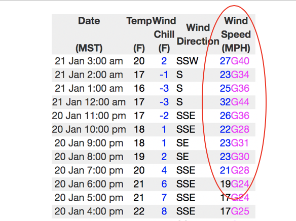
Tuesday morning, January 21, 2020
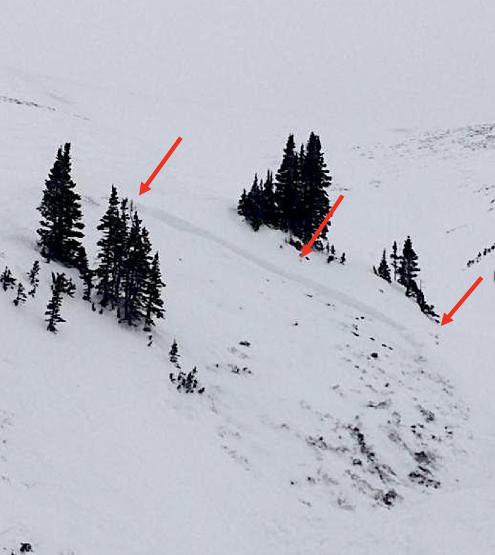
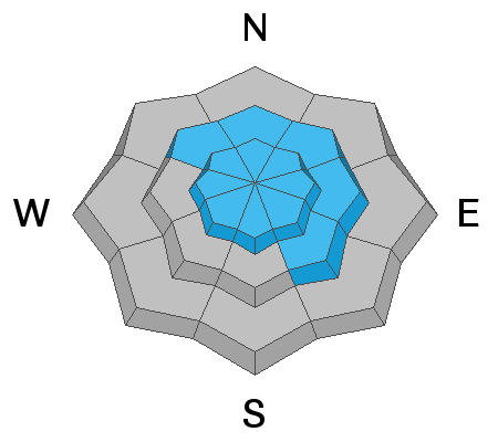
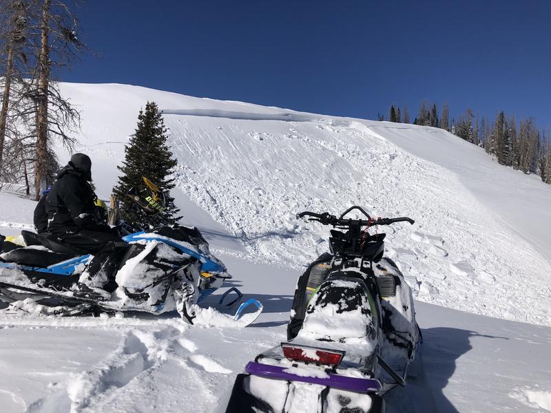
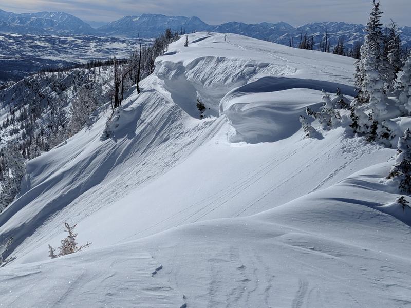
Making up a small portion of the terrain available to ride in today, in the wind zone, deceptively tricky avalanche conditions exist on steep, wind drifted slopes, especially those with an easterly component to its aspect. CONSIDERABLE avalanche danger exists in terrain with these characteristics and human triggered avalanches are LIKELY.
In addition, recent winds drifted snow onto steep, leeward, mid elevation slopes where a MODERATE avalanche danger exists and human triggered avalanches are POSSIBLE. Once triggered, today's drifts may break deeper and wider than you might expect.
Your exit strategy... generally LOW avalanche danger is found on wind sheltered, low and mid elevation slopes with no steep terrain above or adjacent to where you're riding.
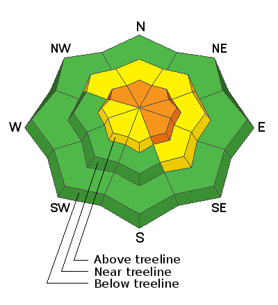
Low
Moderate
Considerable
High
Extreme
Learn how to read the forecast here
Special Announcements
We are very sad to report an avalanche fatality that happened Saturday above Farmington Canyon. A 18 year old, male snowmobiler was caught, fully buried and killed. Preliminary info available HERE. We will re-visit the scene today and have a full report available in the coming days. Our deepest condolences go out to the friends, family, rescuers, and everyone affected by this tragic accident.
Weather and Snow
Currently-
High clouds linger over the region as moisture pumps into the area from the south. Temperatures remained warm overnight, only dipping into the low 20's, where they sit as I type this morning. Southerly winds began ramping up around 7:00 last night and currently blow 25-40 mph along the high ridges.
Uinta weather network info is found here. Simply click on the Western Uinta tab.
With total snow depths hovering right around 60", coverage across the range is all time. And while sunny slopes took on some heat yesterday, riding and turning conditions remain quite good, especially on wind and sun sheltered slopes. Andy and Bo got out and got after it yesterday, covering miles and miles of terrain, and have a great trip report posted here.
For today-
A weak storm sliding through the eastern front delivers wind and clouds, but little in the way of precip. High temperatures climb into the 30's with overnight lows dipping into the 20's. Southerly winds are gonna be a nuisance along the high peaks where they'll blow in the 40's as the day progresses.
Futurecast-
A better shot of snow materializes for tonight into Wednesday. Not a big storm, but enough for a quick refill.
Recent Avalanches
Yesterday, Downtown Chris Brown spotted this pocket in Upper Weber Canyon and noted... "Had a very touchy hair trigger avalanche on E/NE about 9,600' 42* roll at the bottom of slope. 18"+ deep 50' wide, only ran 40' into gully, very sensitive, ran on almost the ground, suspected facet grains were the culprit."
To view additional trip reports and recent avalanche activity, simply click here.
Ad
Avalanche Problem #1
Persistent Weak Layer
Type
Location
Likelihood
Size
Description
While becoming more the exception rather than the rule, today, we can still trigger a deep, dangerous slide like the one in the image above triggered early this week on the south half of the range.
The recent string of warm days helps the snowpack settle and gain strength. And its this slow change over time that helps decrease the chance of triggering a deep, scary avalanche... and that's good news. However, we're not quite out of the woods just yet and I still think steep, rocky, upper elevation terrain facing the north half of the compass remains suspect. So... while so much of our terrain is good to go, if you're travels take you to steep, technical slopes today, think about your exit strategy and the consider the consequences of triggering a slide that has the potential to break deeper and wider than you might expect. Or.... with all the good riding out there and miles of terrain to choose from, simply avoid slopes with these characteristics.
Avalanche Problem #2
Wind Drifted Snow
Type
Location
Likelihood
Size
Description
Winds increased overnight and will have no problem finding what loose snow there is available for transport and whip it into a fresh round of drifts. Most prevalent on the leeward side of upper elevation ridges and around terrain features like chutes and gullies, yesterday I found most drifts a bit lifeless and unreactive to my additional weight. However, the Uinta's are a big place and I still think you could trigger a rogue slab that breaks deeper and wider than you might expect, creating a slide that quickly gets out of hand. Your best bet for avoidance is to simply steer clear of any fat, rounded piece of snow, especially if it sounds hollow like a drum.
Cornices are a great indicator to recent winds and this year they're massive and have the potential to break back further than you might expect.
Additional Information
Thanks to the generous support of our Utah ski resorts and Ski Utah, we have discount lift tickets available. All proceeds support the UAC. Get your tickets HERE.
Get one of these cool t-shirts to support the UAC and other avalanche centers across the U.S. INFO
General Announcements
The information in this forecast expires in 24 hours, but will be updated by 7:00 AM Wednesday Jan. 22nd.
This forecast is updated daily by 7:00 AM.
In the mean-time, if you see or trigger an avalanche or just wanna let me know what you're seeing you can reach me directly at 801-231-2170
It'll be a minute or two before we're riding, but while you're waiting....
This is a great time of year to schedule one of our free avy awareness presentations.
You can email me directly [email protected]
The information in this forecast is from the US Forest Service which is solely responsible for its content.