Forecast for the Uintas Area Mountains

Craig Gordon
Issued by Craig Gordon for
Wednesday, January 2, 2019
In the wind zone, at and above treeline the avalanche danger is MODERATE and human triggered avalanches are possible on steep, wind drifted slopes.
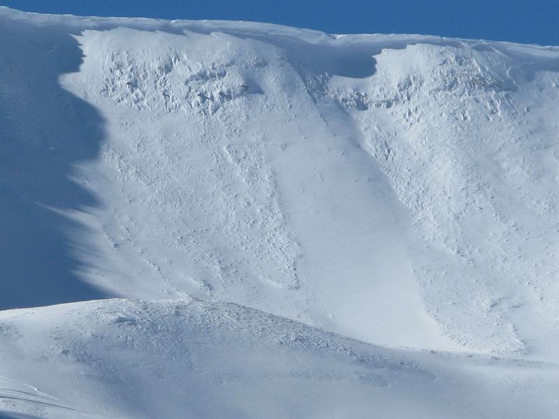
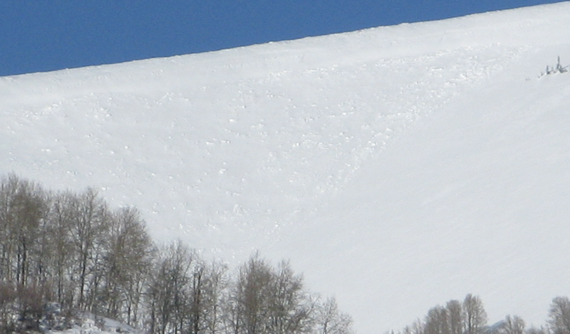
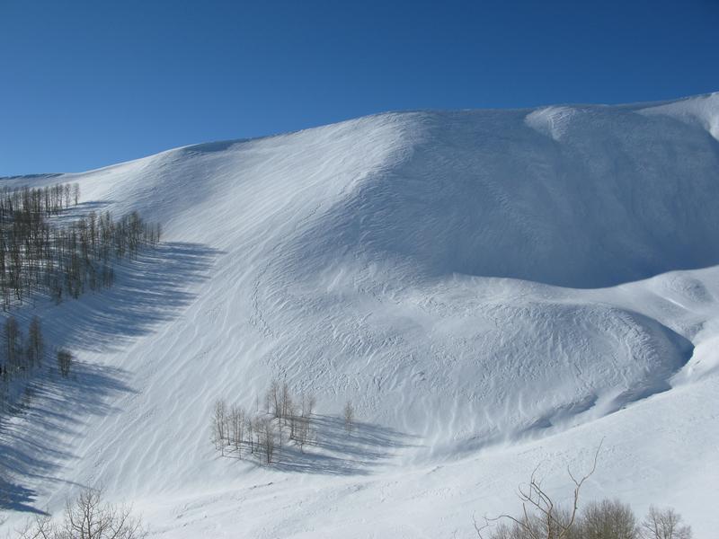
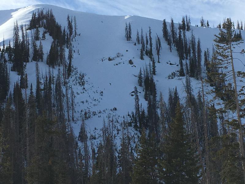
Heads up- more pronounced in the wind zone and on slopes with a thin snowpack, an avalanche triggered in steep, rocky terrain has the potential to quickly get out of hand if it breaks into deeper buried weak layers near the ground.
If you're looking for LOW avalanche danger, simply head to wind sheltered slopes with no steep terrain above or connected to where you're riding or rip deep trenches in big, open meadows.
Low
Moderate
Considerable
High
Extreme
Learn how to read the forecast here
Weather and Snow
Skies are clear and temperatures are 10-15 degrees degrees warmer than yesterday at this time, currently registering in the teens and single digits. Northerly winds are light, blowing less than 15 mph along the high peaks. Unfortunately it's too little, too late as the New Years Eve powder punishing east and northeast winds ruined a remarkable amount of upper elevation snow, transforming many slopes into a wind sculpted tundra. However, don't let your heart be troubled.... lose a little elevation, head to wind sheltered west and southwest facing terrain, and you'll be rewarded with cold, shallow, pow.
Above is recent hourly data from Trial Lake (9,945') along with wind data from Windy Peak (10,662'). To view more regional weather stations click here.
East and northeast winds cranked into the 40's and 50's on New Years Eve, ravaging our big, open bowls.
Hopefully 2019 starts better than 2018 ended. On the bright side.... I've got your back and there's one less nail to blow your tire of stoke on the highway of life :)
Recent Avalanches
Most of the recent avy activity from the big New Years Eve wind event was pockety and not particularly connected.
The avalanche on a southwest facing aspect in the image above was an outlier and the most connected piece of snow I saw in my travels. I think it ran early in the storm, but the crown filled in quickly. Breaking about 18" deep x 300' wide, this slide appears to have failed on weak snow in the midpack, most likely facets resting on a melt-freeze crust. I think this instability is short-lived, but something to keep an eye on.
Ad
Avalanche Problem #1
Wind Drifted Snow
Type
Location
Likelihood
Size
Description
Monday's east and northeast winds cranked into the 40's and 50's along the high ridges, which is a peculiar direction for us. With no shortage of snow available for transport, fresh batches of wind drifted snow formed in unusual locations and on slopes we normally see stripped by the wind. Yesterday I found the stiff drifts pretty welded in place and unreactive to my additional weight. However, the Uinta's are a big place and there may still be a rogue slab or two lurking along the leeward side of upper elevation ridges or even a little lower downslope than we usually experience. In addition, look for recent drifts cross-loaded around terrain features like chutes and gully walls. As always, look for and avoid any fat, rounded piece of snow especially if it sounds hollow like a drum. Remember- cracking out in front of your skis, board, or sled are big red flags to unstable snow.
The image above illustrates plenty of terrain features for snow to crossload onto, creating pockets of stiff wind drifted snow that may still be reactive to our additional weight.
Avalanche Problem #2
Persistent Weak Layer
Type
Location
Likelihood
Size
Description
Not much has changed on the persistent weak layer front, though I think we're trending towards a stronger snowpack in the zones where the pack is deep. But remember- "persistent weak layers" in the snowpack are a headache because they remain problem children for long periods of time. And all we need to do is find one weakness, maybe around a bush or rock that we can't see buried underneath the snow, collapse the pack, and now we're getting worked by a large piece of moving of snow. The usual suspect terrain comes to mind- steep, rocky slopes with a shallow snowpack, along with periphery terrain which harbors a thin, weak snowpack, and slopes that already avalanched earlier this year. So the way I'm avoiding this scenario is by simply avoiding the terrain where this setup exists.
Steep, rocky slopes, with a thin snowpack... complex terrain like in the image above is the kind of place where you could trigger a slide that breaks to weak snow near the ground.
Mike submitted this snowpit above, showing a deeper snowpack and more homogenous layering and stability.
Additional Information
High pressure builds over the area today and tonight with a few passing high, thin clouds at times. Temperatures rise into the low 20's with overnight lows in the single digits. Winds remain light and northerly. The next storm appears to arrive Sunday, though it looks like a splitter with little energy or moisture on tap for us.
General Announcements
The information in this advisory expires 24 hours after the date and time posted, but will be updated by 7:00 AM Thursday January 3rd, 2019.
If you're getting out and about, please let me know what you're seeing especially if you see or trigger and avalanche. I can be reached at [email protected] or 801-231-2170
It's also a good time to set up one of our very popular avalanche awareness classes. Reach out to me and I'll make it happen.
This information does not apply to developed ski areas or highways where avalanche control is normally done. This advisory is from the U.S.D.A. Forest Service, which is solely responsible for its content. This advisory describes general avalanche conditions and local variations always occur.