Forecast for the Uintas Area Mountains

Craig Gordon
Issued by Craig Gordon on
Thursday morning, January 15, 2026

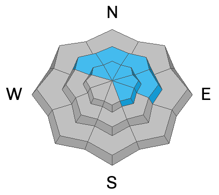
In the wind zone at and above treeline, you'll find MODERATE avalanche danger and human triggered avalanches are POSSIBLE. Fresh drifts on the leeward side of solar facing ridges will react to our additional weight and could catch you off guard on a sustained, steep slope. In addition, it's becoming more the exception than the rule, but avalanches breaking up to 4' deep and failing into persistent weak layers near the ground on steep, polar aspects are still POSSIBLE. You know this program and you're familiar with usual suspects... steep, rocky terrain, with a shallow weak snowpack is guilty until proven otherwise.

Note to self... a little bird on my shoulder (actually a mid-size parrot in my puffy :) tells me, practice some patience and give the snowpack a little more time before stepping into big, rowdy, committing terrain. With no major changes in the weather department, I sense the avy hazard is trending towards LOW.

Low
Moderate
Considerable
High
Extreme
Learn how to read the forecast here
Weather and Snow

Nowcast - Why wouldn't you get out of the junky, funky, gunky valley air and head to the mountains where the skies are clear and fresh O's, along with temperatures registering in the upper 20's °F await your arrival. Our recent 36 hour run of winds blowing 20-40 mph from the Nor' and Nor'east, are finally relaxing and winds currently register in the teens.

Forecast - A sunny day with slightly cooler temperatures climbing into the upper 30's °F is on tap. Winds blowing from the north increase a smidge, ushering in slightly cooler air with overnight lows dipping into the upper teens.

Futurecast - Nothing new in the weather department. Continued severe clear, warm, and dry through about the 22nd.

Travel Conditions - Riding and turning conditions across the range have deteriorated somewhat, but there's a go anywhere base to stretch your wings and get out and explore. It's still thin at lower elevations, just about 1'-2' of total snow depth, but the Christmas Eve raincrust keeps us off the ground at mid and upper elevations where depths average 3'-5'. Strong sunshine and warm temps have had their way with solar aspects and low elevations. But don't let your heart be troubled... wind sheltered, mid and upper elevation north-facing terrain offers spongy, dry powder, on a very reboundable base.

Our mainman with the Uinta plan, Ted Scroggin, was out and about yesterday and says... "Some riders have been testing the waters and stepping into some bigger terrain in the Whitney Basin... I have been nibbling at the edges and feeling a little more confident in the snow pack as it gains some strength and stability." Good words of advice from a guy that knows the range better than anyone.

Recent Avalanches

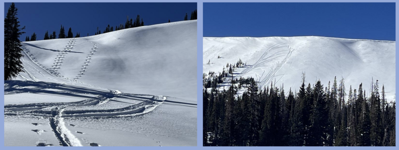
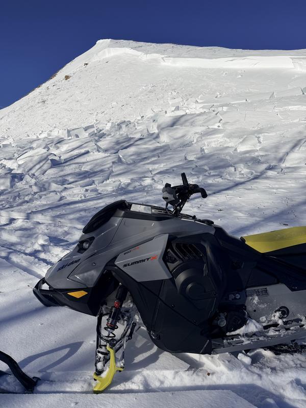
Yesterday, avy-savvy snowpro, DJ Osborne triggered this hard, meaty, wind-drift on a steep, windloaded slope on the south half of the range near Smith Basin. More deets HERE.

Click on the button below to scroll through a history of this winter.

Avalanche Problem #1
Persistent Weak Layer
Type
Location
Likelihood
Size
Description

The snowpack is getting comfortable in its own skin and the likelihood of triggering a deep, dangerous avalanche is decreasing... and that's good news. So, it's not like rolling craps in Vegas, maybe a bit more like Minesweeper, play it long enough and eventually we're bound to stumble onto the booby trap. Remember, all we need to do is find a thin portion of the snowpack, like around a rock or bush, collapse the weak layer (whumpf), and now we're staring down the barrel of a dangerous avalanche. Don't forget, today's persistent slab avalanches are tricky, unmanageable slides. Instead of trying to outsmart the avalanche, avoidance is the go-to tool. I'm steering clear of the problem until it no longer exists or is buried deep enough and on the road to healing.

Ted and I stomped around the periphery of Chalk Creek Tuesday and found encouraging news where our snowpack is deep.

Avalanche Problem #2
Wind Drifted Snow
Type
Location
Likelihood
Size
Description

24 hour data dump from Currant Creek Peak (10,547') illustrating the velocity and duration of north and northeast winds.

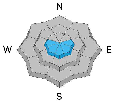
I think the majority of drifting has subsided, but the Uinta's are a ginormous range and I bet there's a stubborn, hard drift or two lurking on the south half of the compass where north and northeast winds have worked overtime. Easy to detect by their fat rounded appearance, they're even easier to avoid by losing a little elevation and steering towards wind sheltered slopes.

General Announcements

We have some upcoming classes and events that we'd be stoked to see you at -- Please reach out with any questions and check out below for more details!

We are always looking for snow and avalanche observations or just general riding conditions. Reach out to us with questions, concerns, or if you see anything in your travels! Contact us directly through the info below:

This forecast is from the U.S.D.A. Forest Service, which is solely responsible for its content. This forecast describes general avalanche conditions, and local variations always occur. This forecast was issued on Thursday, January 15th at 0400 AM and expires 24 hours after it was issued. We'll update this information by 07:00 AM tomorrow.