Last Saturday, a group of snowbikers triggered a slide that fully buried their friend north of Logan. Because they all had avalanche transceivers, probes and shovels and he was uninjured by the slide, they made a successful recovery.
If you're searching for an alternative to avoid dangerous backcountry conditions, well look no further. Thanks to the generous support of our local resorts, Ski Utah, and Backcountry, discount lift tickets are now available. Support the UAC while you ski at the resorts this season. Tickets are available
here.Nowcast-
Winds eased some since yesterday everywhere except on Currant Creek Peak where they are blowing 35 mph from the NW gusting to 50 mph. In all other places, NW winds are blowing 10-20 mph gusting 25-35 mph. Temperatures this morning are in the mid to upper teens F and skies are clear.
Forecast-
Today will be noticeably warmer than yesterday with high temperatures near 32 degrees F. Through the day winds will slowly decrease and skies will become increasingly cloudy. Tonight a trace to 1 inch of snow should fall.
Futurecast-
Another inch of snow could fall Monday night followed by dry conditions for the rest of the week. The good news is that the weather pattern becomes increasingly active with snowfall expected next weekend.
Looking for real-time temps, snow, or wind?
Click
here and then on the "western Uinta" tab for western Uinta specific, weather station network.
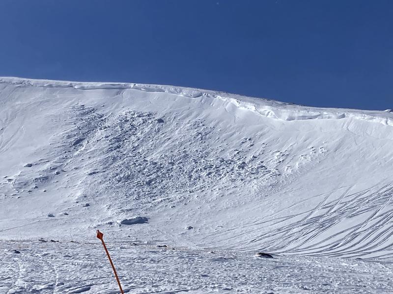
Yesterday on Tower Mountain just north of Currant Creek Peak, there was one
natural avalanche that happened from recent westerly winds drifting snow and building the cornice on the east-facing part of Tower Mountain. A group in a week-long professional avalanche class saw this avalanche and also submitted this
great report.
Read other trip reports
here.