Forecast for the Uintas Area Mountains

Mark Staples
Issued by Mark Staples on
Thursday morning, January 14, 2021
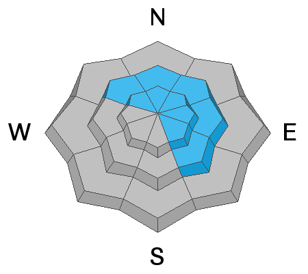
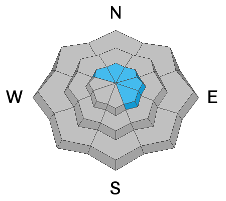
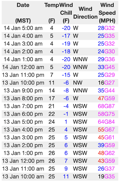
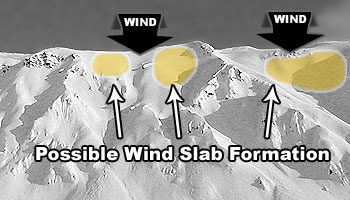
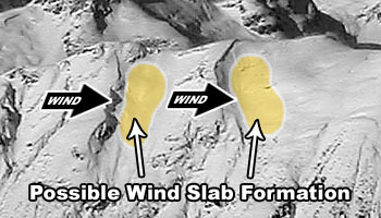
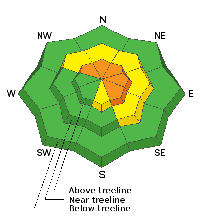
Today the most dangerous places are upper elevation slopes that have any amount of wind deposited snow facing northerly and easterly, and the avalanche danger is CONSIDERABLE in these areas.
Mid elevations slopes, out of the wind but facing northerly and easterly, have a MODERATE danger. Triggering an avalanche in these areas remains possible because the bottom foot of snow is very weak but it hasn't been stressed by recent snowfall or wind drifted snow.
A LOW danger exists at low elevations with minimal snow as well as mid and upper elevations slopes that have been stripped of snow by recent winds.

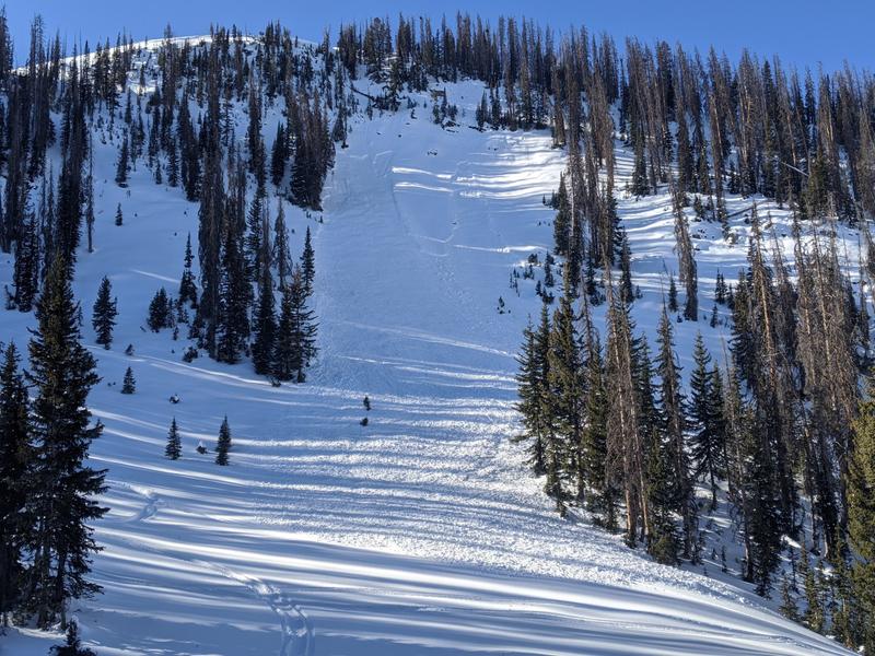
The challenge is that slopes with the most snow are generally ones with a greater avalanche danger. For now, the main strategy to avoid avalanches is to ride low angle slopes.
Low
Moderate
Considerable
High
Extreme
Learn how to read the forecast here
Special Announcements
Last Saturday, a group of snowbikers triggered a slide that fully buried their friend north of Logan. Because they all had avalanche transceivers, probes and shovels and he was uninjured by the slide, they made a successful recovery.
If you're searching for an alternative to avoid dangerous backcountry conditions, well look no further. Thanks to the generous support of our local resorts, Ski Utah, and Backcountry, discount lift tickets are now available. Support the UAC while you ski at the resorts this season. Tickets are available here.
Weather and Snow
Nowcast-
Yesterday was warm and windy with a few rain drops reported yesterday evening in the Heber Valley. Temperatures reached the 30s and 40s F in the mountains yesterday, and winds above 10,000 feet were blowing 30-40 gusting 60-80 from the WSW. This morning temperatures dipped into the low teens and single digits F and winds eased to more normal speeds from the west and northwest.
Forecast-
Today should remain blustery because we're sitting in between a storm system to the east and a ridge of high pressure to the west. Those two weather features are squeezing winds between them and will keep wind speeds a bit elevated today. They should generally blow 10-20 mph from the NW with gusts of 30 mph. It'll be a beautiful sunny day with temperatures that should reach the low 20s F.
Futurecast-
There's a chance for a few inches of snow on Monday. Long range weather models show more snow next weekend, but we'll see.
Looking for real-time temps, snow, or wind?
Click here and then on the "western Uinta" tab for western Uinta specific, weather station network.
Recent Avalanches
No avalanches have been reported but read trip reports here.
Backcountry Institute and the American Avalanche Institute are teaching a week-long professional avalanche class in the Uintas. Yesterday they found mixed results (some good, some bad) in their snowpack tests. What that means is that it's getting harder to trigger an avalanche now, but the snowpack structure is still capable of producing avalanches. What's lacking is the stress from the weight of new snow.
Photos below show one of the students testing the snowpack and a close up of the weak, faceted, sugary snow near the ground (A. Richards, E. Kimber).
Ad
Avalanche Problem #1
Persistent Weak Layer
Type
Location
Likelihood
Size
Description
The bottom third of the snowpack is all weak, rotten, faceted snow which is the persistent weak layer. A cohesive slab 1-2 feet thick rests on top of this weak layer. This set up is the exact recipe for avalanches, but they have gotten harder to trigger. What's espeically dangerous about this set up is that you don't have to be on a slope to trigger it, just tickling it from the bottom can trigger an avalanche.
This weak snow exists throughout the Uinta Mountains on NW through SE aspects. What is more variable is the slab on top. Places to trigger an avalanche are where the slab is thicker and more cohesive. Slopes receiving even just a little wind-blown snow will have this cohesive slab. Yesterday's strong winds (see discussion below) likely founds some snow to transport and have kept this avalanche problem alive.
This avalanche on Hoyt Peak is almost a week old but shows the type of avalanches we're dealing with. It was 18-24 inches deep and 200 feet wide triggered by a snowmobile low on the slope.
Unfortunately, this avalanche problem will be with us for most of the season. The tricky part now is that slopes with the most snow where we want to ride are ones where this avalanche problem exists. The way to avoid it is by simply avoiding avalanche terrain which means riding slopes less than 30 degrees in steepness.
Avalanche Problem #2
Wind Drifted Snow
Type
Location
Likelihood
Size
Description
Really strong winds blew at upper elevations yesterday afternoon and evening with gusts reaching 87 mph from the WSW. See below. There isn't much fresh snow for winds to transport, but those strong winds likely found some. Fresh slabs of wind drifted snow can produce small avalanches on their own. Look for pillows of wind drifted snow from top loading under ridges or from cross loading along other terrain features.
The bigger problem is that wind-blown snow will add weight and cohesion to slabs resting on the persistent weak layer described above. Avalanches breaking on that layer will be much larger.
The image above illustrates increased winds yesterday afternoon and evening at the Windy Peak weather station at 10,600'.
Below are typical patterns of top loading and cross loading.
Additional Information
I'll update this forecast by 7:00 AM tomorrow, Friday January 15th.
Your observations are import, so please let me know what you're seeing... click HERE and contribute to this amazing community based program
General Announcements
If you see or trigger an avalanche or just wanna let me know what you're seeing you can reach me directly at 801-231-2170 or [email protected]
This forecast is from the U.S.D.A. Forest Service, which is solely responsible for its content. This forecast describes general avalanche conditions and local variations always occur.