Forecast for the Uintas Area Mountains

Craig Gordon
Issued by Craig Gordon for
Wednesday, January 12, 2022
MODERATE avalanche danger exists near and above treeline, especially in the wind zone. While not widespread and becoming pockety in nature, deep, dangerous, human triggered avalanches are still POSSIBLE. I'd tread lightly in steep, rocky terrain facing the north half of the compass and continue avoiding slopes with a shallow, weak, snowpack.

On a go-anywhere base with a little cream on top, there's no shortage of great riding options with less dangerous avalanche conditions. You'll find generally LOW avalanche danger today on slopes facing the south half of the compass and terrain less than 30 degrees in steepness.
Low
Moderate
Considerable
High
Extreme
Learn how to read the forecast here
Weather and Snow
NOWCAST-
Skies are clear, winds light and northerly, and temperatures inverted, registering in the teens at the trailheads and mid 20's along the ridges. It's been nearly a week since our last storm, but there's still some shallow, cold cream on top of a go-anywhere-base. Under today's brilliant sunshine, riding and turning conditions are about as good as they get.
FORECAST-
High pressure continues homesteading over the area, strengthening through Thursday. Look for mostly sunny skies, light winds, and temperatures climbing into the mid 30's. Overnight lows dip into the teens and mid 20's.
FUTURECAST-
Mostly sunny skies, light winds, and a warming trend are on tap through most of the week.
Ka-Pow! Ted reports excellent shallow powder riding conditions on very supportable, go-anywhere base.

Looking for real-time temps, snow, or wind?
Click HERE and then on the "western Uinta" tab for western Uinta specific, weather station network.
Recent Avalanches
No significant avalanche activity to report

Click HERE for a list of recent avalanches.
A list of all other observations is found HERE

Your input is vital and we're interested in what you're seeing. Please contribute to this great community resource and go here to fill out an observation.
Ad
Avalanche Problem #1
Persistent Weak Layer
Type
Location
Likelihood
Size
Description
Exec. Director Chad Brackelsberg stomped around mid Weber Canyon over the weekend, finding mostly stable snow and great riding conditions. In the video above, Chad describes his findings whilst conducting a Propagation Saw Test (PST). His results as well as our collective observations and lack of avalanche activity suggest we're shifting towards more stable snowpack characteristics, but still remain in the "low probability/high consequence" realm. An oldie, but a goodie, Trent explains how to set up and interpret this test.
Here's the setup-
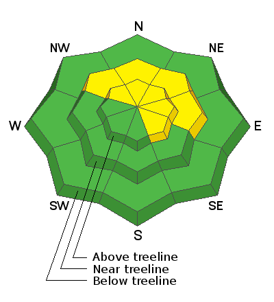
We're moving in the right direction and trending towards a snowpack becoming happy in its own skin as the persistent weak layer (PWL) of faceted, old, sugary snow near the ground slowly adjusts to the big December storms. However, let's not forget... a tremendous amount of dense, heavy, water laden snow piled up on a pre-existing fragile, shaky base and we can't take our eyes off the prize. Sure, all of the snow since Christmas is a good thing that eventually heals this weak layer, but it doesn't happen overnight. Indeed, things are calming down, avalanche activity isn't off the charts, and it's been nearly a week since any significant slides have been reported. But the big red flag is that last weeks avalanches continue breaking on our early season problem child or, in snow-geek-speak... persistent weak layer (PWL). So, while conditions are slowly improving, I'd continue steering clear of any steep, rocky, wind drifted slope, especially those facing the north half of the compass, that harbor old October snow.
For now what makes this layer dangerous is:
  • Once triggered, avalanches may break hundreds of feet wide.
  • Avalanches will be 3-5 feet deep.
  • It may not be the first person on a slope that triggers A LARGE, DANGEROUS avalanche, it may be the second, third, fourth, etc. who triggers it.
  • Seeing tracks on a slope DOES NOT mean it's safe.
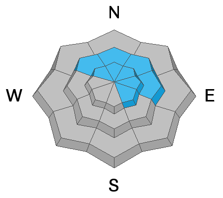
Here's the good news - This layer doesn't exist on south facing slopes which have excellent coverage, and soft creamy powder.
Additional Information
Your observations are important, so please let me know what you're seeing... click HERE and contribute to this amazing community based program
General Announcements
The information in this forecast expires 24 hours after the day and time posted, but will be updated by 07:00 Thursday January 13th.
Before it gets too crazy, now is the time to book an avalanche awareness presentation for your group, club, or posse. You can reach me directly at 801-231-2170 or [email protected]
This forecast is from the U.S.D.A. Forest Service, which is solely responsible for its content. This forecast describes general avalanche conditions and local variations always occur.