Join us at our 2nd Annual Blizzard Ball

Forecast for the Uintas Area Mountains

Craig Gordon
Issued by Craig Gordon on
Tuesday morning, January 10, 2023
We're got two distinct avalanche dragons today... one that predictably breaks at or below our feet. And one that gets quickly out of hand, failing into weak layers, now buried deep in our snowpack-
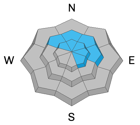
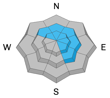
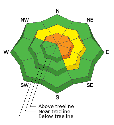
In either case... CONSIDERABLE avalanche danger is found on steep, upper elevation slopes, especially in the wind zone at and above treeline. The danger is most pronounced in terrain facing the north half of the compass, particularly on slopes with an easterly component to their aspect. Natural and human triggered wind drifts, along with more dangerous slides breaking to weak layers now buried deep in our snowpack are LIKELY. Lose some elevation, you lose some wind and most of the problem, though a rogue piece of snow can still break deeper and wider than you might anticipate. Expect MODERATE avalanche danger on steep, shady mid elevation slopes where human triggered avalanches are POSSIBLE.
Generally LOW avalanche danger is found on west, south, and southwest facing slopes and all aspects below treeline.
Low
Moderate
Considerable
High
Extreme
Learn how to read the forecast here
Weather and Snow
Nowcast- Under mostly cloudy skies, snow continues falling, adding to last nights respectable shot of snow which delivered 8"-10" with about an inch of H2O... in other words, a bit on the heavy side. Temperatures resister in the teens and mid 20's while southerly winds blow 20-30 mph along the high ridges. Last nights refresh will help cushion some of the recent wind funk, especially in big, open terrain.
Forecast- Snow continues this morning with an additional 6" stacking up in the next few hours, before a midday break in the action. High temperatures climb into the upper 20's and southwest winds ramp up, with gusts in the 50's later today as yet another solid slug of moisture heads our way. An additional 6" overnight feels like a good bet.
Futurecast- Snow continues Wednesday with high pressure building Thursday into Friday, resulting in a temporary lull. More storminess returns over the weekend and into early next week.
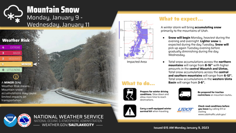
Our partners at the NWS give us a peak behind the curtains for the first half of the upcoming week in the image above.

Huge thanks for all the great obs streaming in from the eastern front. Detailed trip reports and recent obs are found HERE.
Recent Avalanches
Roofalanches are a real hazard and can instantly ruin your day. Our mountainside cabins are loaded with snow and can shed the entire seasons snowpack once we start the getting the fire roaring on the inside.
No significant recent avy activity... but a slew of Uinta avy obs are found HERE.
Ad
Avalanche Problem #1
Persistent Weak Layer
Type
Location
Likelihood
Size
Description
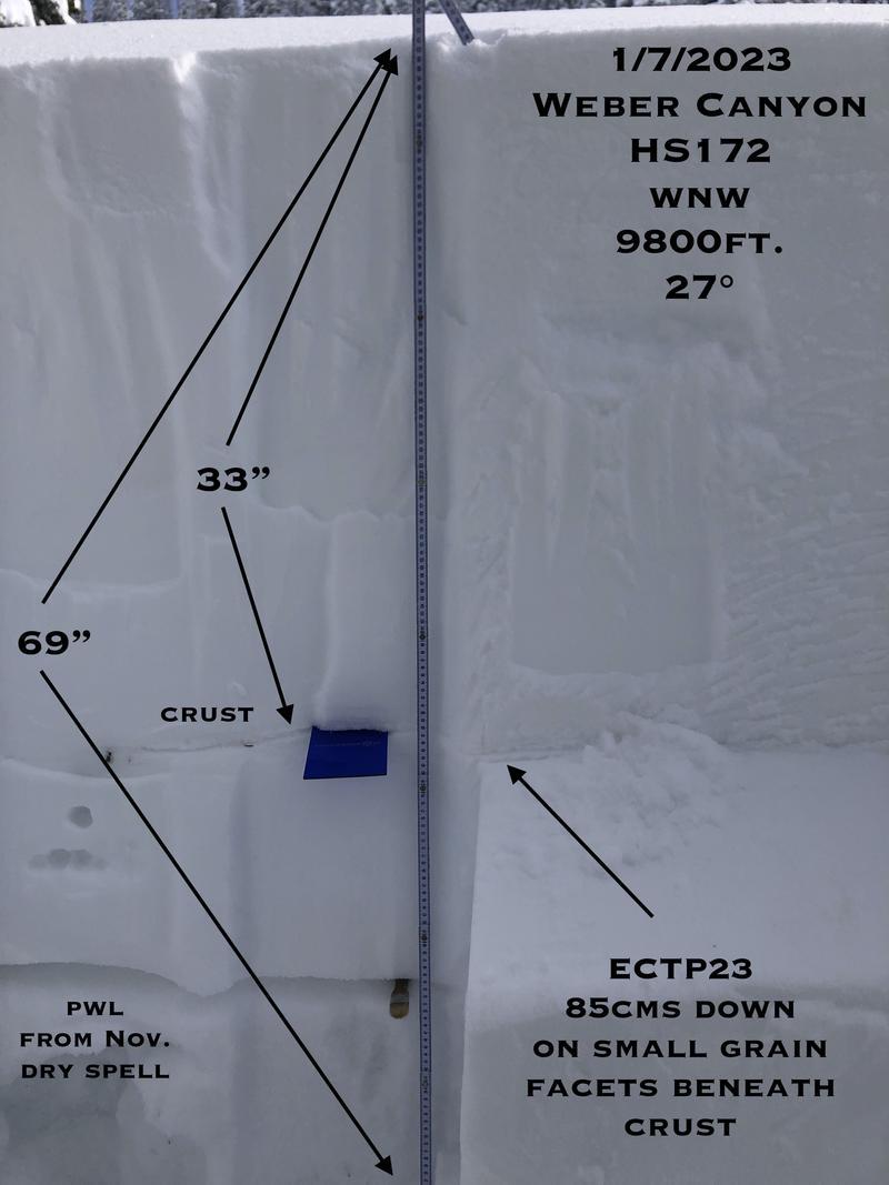
It's been a minute or two since we had the pleasure to see a snowpit image from longtime western Uinta observer JG and I'm psyched to have the opportunity to post one of his beautiful pit profiles.... Muchas Gracias Mi Amigo :)
Our snowpack is becoming deep and more solid with each additional layer of insulating snowfall and that's great news! And while the chances of triggering a deep dangerous avalanche are becoming less likely over time it's not entirely impossible... all we need to do is find one weakness in the pack, pull the rug out from underneath, and the entire roof crashes down on us. No... it's not like the walls are caving in and that'll make today that much more deceptive. Now is the time to start stepping out cautiously, gathering as much snowpack intel we can along the way. Stomp on small steep test slopes and road cuts and see how they're reacting before setting your sights on a big, committing line. And if it isn't feeling right, pump the brakes and recalibrate your objectives, because with all the great mid and lower angle riding available, there's no reason to pull on the avalanche dragons tail.

Avalanche Problem #2
Wind Drifted Snow
Type
Location
Likelihood
Size
Description
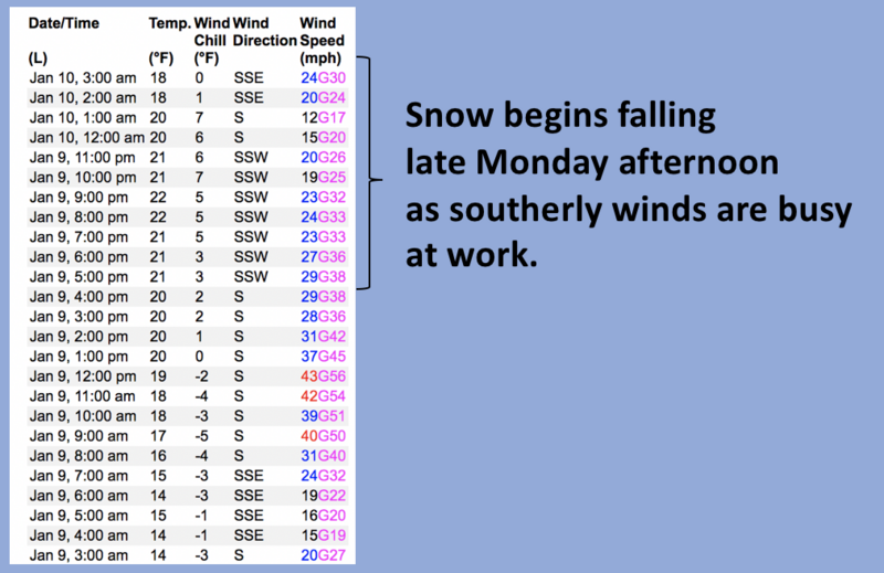
A 24 hour data dump from Windy Peak (10,662') clearly showing trends of recent winds.
Winds are always the great equalizer for the western Uinta's and yesterday was no different. There's no shortage of snow available to blow around and form fresh drifts that'll react to our additional weight. Found mostly on the leeward side of upper elevation ridges, I wouldn't be too surprised to find drifting around terrain features like chutes and gullies. In either case, the key to riding safely is simply avoiding fat rounded pillows of snow, especially if they're sounding hollow like a drum. Lose the wind and you lose the problem.
Additional Information
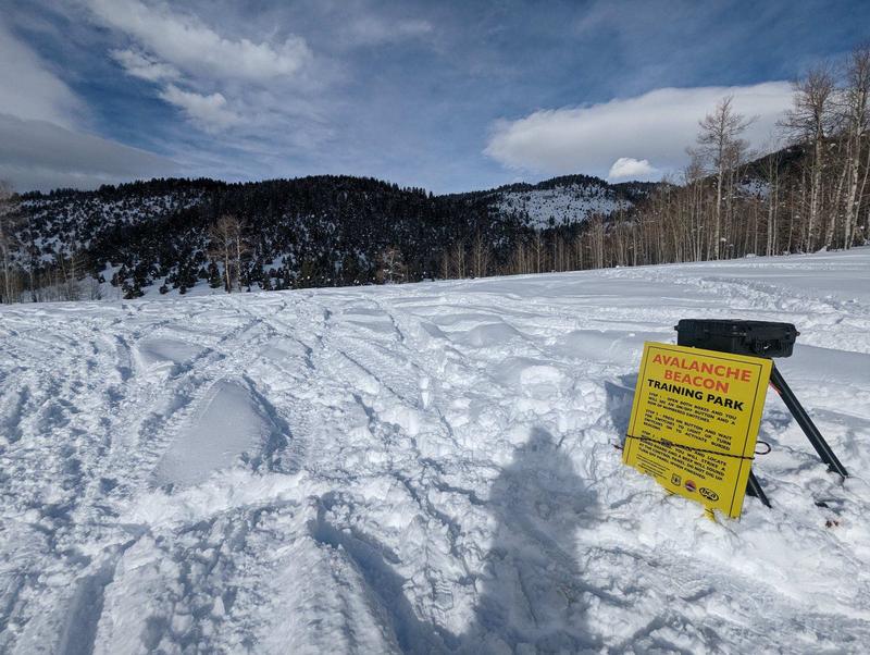
Such a rock star! Huge thanks to Joey Manship for all the hard work and Herculean efforts getting the Nobletts Beacon Park up and running. Located on the northeast corner of the parking lot, give it a go and practice your rescue skills on a down day, or while you wait for your crew before a ride.
Weather stations-
And... we were super busy this summer upgrading the western Uinta weather station network and this real-time winter info is found HERE (click weather stations, and then on the Western Uinta tab)
Observations-
Your observations are important, so please let me know what you're seeing... click HERE and contribute to this amazing community-based program
General Announcements
Issued at 03:37 on Tuesday January 10h, this forecast expires 24 hours after the date and time posted, but will be updated by 07:00 Wednesday January 11th, 2023.
Before it gets too crazy, now is the time to book an avalanche awareness presentation for your group, club, or posse. You can reach Craig directly at 801-231-2170 or [email protected].

This forecast is from the U.S.D.A. Forest Service, which is solely responsible for its content. This forecast describes general avalanche conditions and local variations always occur.