Donate Now to Our Year End Campaign!

Forecast for the Uintas Area Mountains

Craig Gordon
Issued by Craig Gordon on
Thursday morning, December 25, 2025

For today, at and above treeline, two flavors of MODERATE avalanche are found. First, the most dangerous and unpredictable... human triggered avalanches, breaking two to four feet deep are POSSIBLE, especially on steep, rocky, slopes where a hard, dense slab sits above multiple persistent weak layers. Second and a little more straight-forward... recently formed wind-drifts on the leeward side of ridges, or around terrain features like gully walls, chutes, and cut banks that will react to our additional weight.

In either case, I'm avoiding steep, wind drifted slopes.

Low
Moderate
Considerable
High
Extreme
Learn how to read the forecast here
Weather and Snow

Yo... yo... yo... Merry Christmas :)

Nowcast - Apparently my weather optimism eclipses my weather forecast! Sure, I nailed the wind... blowing from the south 30-50 mph gusting into the 70's, but I flailed on the snow and water... trace for both. In either case, I feel confident it's gonna be rugged out there this morning and I don't think the mostly cloudy skies with temperatures hovering right around 40°F at the trailheads and near freezing along the ridges make a particularly solid case to get out an get after it before the family wakes up to unwrap gifts. Might wanna hold off 'til tomorrow.

Forecast - Snow showers are just starting to slide into the region and I bet a shallow coat of white paint is in store for terrain above about 9,000'. Cooler air filters into the Uinta's later this morning and that'll help knock temperatures into the low 30's °F. Winds blowing in the 40's and 50's from the southwest, rake the ridges during the day, but decrease later in the day.... right around the time Cindy Lou Who and family sitdown to carve the Roast Beast ;)

Futurecast - Colder air and a little moisture slide into the region overnight and we'll squeak out a couple inches of snow. A lull in the action is on tap for Friday morning, but a colder, more Utah-esque storm swings through northern Utah Friday night into Saturday and that should give us a better shot of snow. I'm still thinking storm totals in the 12 inch ballpark with an inch of water for Saturday mornings ride.

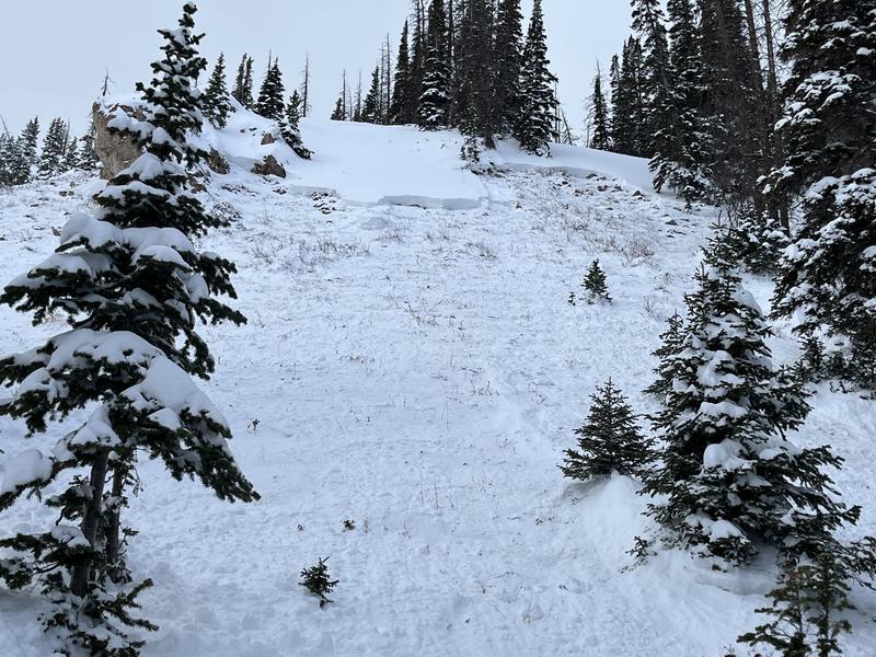
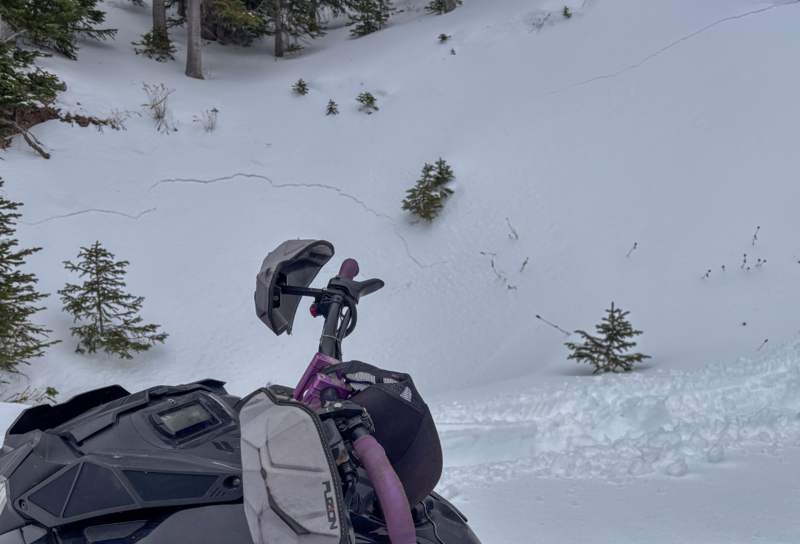
Travel Conditions - What a difference a day makes... and not in a good way. Noah was out and about in the Wolf Creek zone yesterday (great trip report HERE) and confirms our suspicions of a consistently weak and punchy snow structure, along with a mixed bag of variable snow surfaces to keep ya honest and on yer toes. Vehicle access to Mirror Lake Highway (HW150) and Bald mountain Pass is shut down, while SR-35 (Wolf Creek Pass) remains open.

Recent Avalanches

No new avalanche activity to report, but click on the button below for a look into the history of this seasons events.

Avalanche Problem #1
Persistent Weak Layer
Type
Location
Likelihood
Size
Description

Becoming more the exception than the rule, I suspect you could still trigger a slide that breaks deeper and wider than you might expect as illustrated in the image above. (Ted's write-up from earlier this week is found, here.) And while I think recent warm temperatures have somewhat shrink-wrapped our snowpack and it's not nearly as reactive as earlier in the week, I'm not ready to hang my hat (as if I owned one :) on the snowpack structure 'cause it's an untrustworthy gong show. We might forget about the different layers of snow, but the snowpack has an amazing memory and it tells me... early season snow turned persistent weak layer homesteads beneath a strong, dense, cohesive slab that developed from several storms worth of snow, coupled with strong winds. But it's not a one-size-fits-all kinda snowpack and the biggest clue to our quirky snowpacks personality are recently triggered avalanches on mid and upper elevation, polar slopes, breaking 1-3 feet deep, failing on old snow near the ground. Steep, rocky slopes with a thin, shallow snowpack are at the center of the bullseye terrain and need to be avoided.

Here's the conundrum... in wind-sheltered, mid-elevation terrain, the slab is softer and not quite as reactive, but let's not take our eyes off the prize... it's still a strong snow over weak snow setup and that structure is always a big, red flag. Local snowpro and avy-savvy guide Joel O'Rourke posted this observation from the Wolf Creek zone illustrating the current setup.

The snowpack is still suggesting it's reactive to our additional weight. Booming collapses or shooting cracks like on this road cut above Andy's sled are big red flags.

Avalanche Problem #2
Wind Drifted Snow
Type
Location
Likelihood
Size
Description

I suspect most of our snow is either welded or pressed in place and I bet you'd have to go out of your way to trigger a piece of wind drifted snow. However, the Uinta's are a big zone and the terrain can channel snow into unusual places. That said, I'm gonna continue to look for and avoid dense, textured, rounded pillows of snow, especially if they sound hollow like a drum. I'm also steering clear of cross-loaded terrain features like chutes, gully walls, and cut banks.

Additional Information

This fleet can't be beat! Huge thanks to Ski-Doo in partnership with Karl Malone's Plaza Cycle, for arranging our sled, loaner program. This vital state-wide partnership gets sleds into the hands of UAC forecasters, allowing us to see more terrain, gather more snowpack information, and issue more accurate avalanche forecasts. Ultimately, this program helps us save lives!

General Announcements

We have some upcoming classes and events that we would be stoked to see you at -- Please reach out with any questions and check out below for more details!

We are always looking for snow and avalanche observations or just general riding conditions. Reach out to us with questions, concerns, or if you see anything in your travels! Contact us directly through the info below:

This forecast is from the U.S.D.A. Forest Service, which is solely responsible for its content. This forecast describes general avalanche conditions, and local variations always occur. This forecast was issued on Thursday, December 25th at 0400 AM and expires 24 hours after it was issued. We'll update this information by 07:00 AM tomorrow.