Forecast for the Skyline Area Mountains

Brett Kobernik
Issued by Brett Kobernik for
Wednesday, April 5, 2023
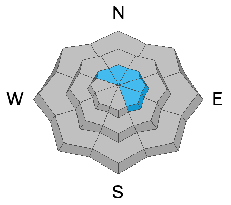
The avalanche danger rating is CONSIDERABLE today in the upper elevation northwest through southeast facing terrain.
Recently formed wind drifts and wind slabs can be human triggered today.
If you avoid the steep upper elevation slopes where the wind slabs are present, the avalanche danger is much lower.
Low
Moderate
Considerable
High
Extreme
Learn how to read the forecast here
Weather and Snow
Current Conditions: The second part of the storm wasn't as robust as advertised but we still picked up 4 inches of snow in the last 24 hours. Strong west wind on Tuesday has been tapering off and is now light to moderate in speed. Temperatures have been in the low teens. Riding conditions are excellent.

Mountain Weather: We'll see lingering clouds and the chance for light snowfall today with a couple of inches possible. Temperatures will remain in the teens and we'll have light wind from the west. We have a stretch of sunny weather and warming temperatures starting Thursday and lasting through the weekend.
Ad
Avalanche Problem #1
Wind Drifted Snow
Type
Location
Likelihood
Size
Description
Recently formed wind drifts and wind slabs along the higher ridges is your main concern today. These formed over the last few days when the wind was blowing quite strong. They will be stabilizing but I wouldn't poke around at them yet today. These drifts and slabs will be most pronounced just below the ridges on northwest through southeast facing terrain in the upper elevations. If you avoid that terrain, the avalanche danger is much less.
General Announcements
This forecast is from the U.S.D.A. Forest Service, which is solely responsible for its content. This forecast describes general avalanche conditions and local variations always occur.