Forecast for the Skyline Area Mountains

Brett Kobernik
Issued by Brett Kobernik for
Tuesday, April 5, 2022
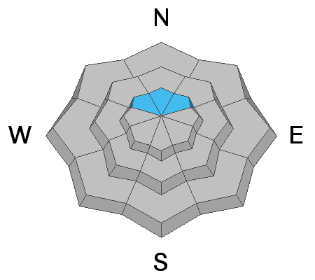
The avalanche danger remains CONSIDERABLE in the upper elevation north facing steep terrain.
Strong wind will increase the danger by transporting loose snow and depositing it onto the already dangerous slopes.
If you simply avoid the steep upper elevation northerly facing slopes that are steeper than 30 degrees, you'll stay safe.
I would also watch for fresh wind drifts on the north through east facing slopes right under the ridgelines as well. This drifted snow may be enough to cause small slab avalanches on its own.
Low
Moderate
Considerable
High
Extreme
Learn how to read the forecast here
Weather and Snow
Current Conditions
WOW!!! It's been windy overnight!! These are the strongest winds that I've seen all winter. I'm seeing averages in the 50mph range along the highest peaks with the strongest gust recorded at 75mph. It is from the southwest. Something else worth nothing is overnight temperatures stayed at 40˚F at most weather stations in the mid and higher terrain.
Mountain Weather
The small storm has been slow to arrive but it will move through this morning possibly bringing a few inches of snow. It certainly isn't anything too exciting except for the very strong wind. It looks like the wind is going to howl at strong speeds right through the day. The direction should turn a little more northwest. Temperatures should actually cool as the this morning's storm brings in colder air. The rest of the week looks quiet with a gradual warming trend. I have my eye on some potential storms for about a week away.
Ad
Avalanche Problem #1
Persistent Weak Layer
Type
Location
Likelihood
Size
Description
There's been nothing that tells me that there's been any improvement with the mid winter Persistent Weak Layer in the lingering northerly facing upper elevation terrain. It's still there. While there's not a lot of loose snow available for transport, the strong wind most likely found something to blow around which actually would enhance the chances of triggering an avalanche. The wind takes snow from one location and deposits it in another. If it gets deposited in an area that already has an existing buried weak layer, it stresses that weak layer and makes it more sensitive. Just avoid that steeper upper elevation north facing terrain, I've given up on trying to figure out when things are going to be 100% stable.
General Announcements
This forecast is from the U.S.D.A. Forest Service, which is solely responsible for its content. This forecast describes general avalanche conditions and local variations always occur.