Forecast for the Skyline Area Mountains

Brett Kobernik
Issued by Brett Kobernik for
Wednesday, March 6, 2024
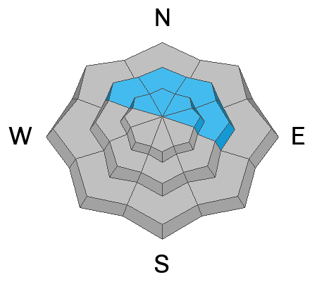
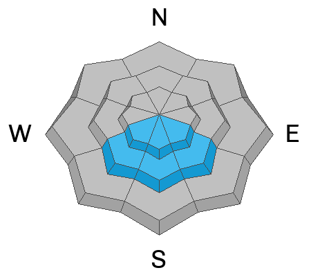
The avalanche danger rating for the Skyline is MODERATE.
Human triggered avalanches are possible on steep slopes that have recent deposits of wind drifted snow.
Very steep north through east facing slopes are the most likely places to trigger something today, especially just below ridgelines.
Low
Moderate
Considerable
High
Extreme
Learn how to read the forecast here
Weather and Snow
Current Conditions: It still felt DEEP out there on Tuesday. Many areas started to feel the effects of the sun and daytime heating which made the snow thick. Northerly facing slopes still hold cold powder. There was a moderate wind from the southwest for most of the day. It's slowed a little but there is still a breeze. Temperatures got into the upper 20s and dropped back into the low 20s overnight.
Mountain Weather: Mostly clear skies this morning should yield to increasing clouds as the day progresses and we could see some light snowfall this afternoon. Not much accumulation is expected. Temperatures will get up to around 30˚F. Wind will remain from the southwest and will gradually slow. Thursday looks similar with increasing wind in the afternoon.
Ad
Avalanche Problem #1
Wind Drifted Snow
Type
Location
Likelihood
Size
Description
On Tuesday I did not think the new snow or fresh drifts were very sensitive. I was not seeing any cracking in drifts that I was poking at. I did not find any significant recent avalanches. It seems that the new snow has settled and stabilized for the most part. I would still avoid very steep slopes that have been wind loaded during the storm.
Avalanche Problem #2
Wet Snow
Type
Location
Likelihood
Size
Description
It's getting to the point in the season where we need to pay attention to daytime heating causing wet avalanche activity. Usually this problem is most pronounced directly after storms when the cold snow gets warm for the first time. It can get to the point where it is unstable and starts to slide. Sunny facing slopes heat up first. Lower elevations already got damp and will have frozen again overnight. This helps with stability so I don't think we'll see issues in the lower terrain.
All that said, I don't think wet avalanches are a big concern for today but keep it in mind.
General Announcements
This forecast is from the U.S.D.A. Forest Service, which is solely responsible for its content. This forecast describes general avalanche conditions and local variations always occur.