UDOT PLANNED AVALANCHE CLOSURES!!

Forecast for the Skyline Area Mountains

Brett Kobernik
Issued by Brett Kobernik on
Tuesday morning, March 4, 2025
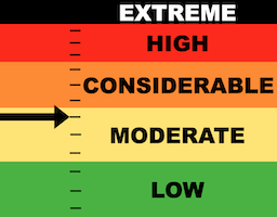
The Manti Skyline has a MODERATE avalanche danger rating today.
The new snow has not increased the avalanche danger much.
There may be some minor new snow activity but your big concern remains triggering an avalanche that breaks deeper into older weak sugary snow.
Chances for triggering a deeper avalanche are not all that great right now but if you do, it will probably break a couple feet deep producing an unmanageable avalanche.
Low
Moderate
Considerable
High
Extreme
Learn how to read the forecast here
Special Announcements
I am pleased to announce that we have a new version of our Utah Avalanche Center app available. This is a huge improvement over our older version which I disliked and did not recommend to anyone. This version has an inclinometer for measuring slope angles. We plan to add new features on the next version this summer but this is a great start and again, a huge upgrade from our previous version.
ANDROID VERSION HERE
IPHONE VERSION HERE
Weather and Snow
Current Conditions: Storm totals came in on the high end of what I was expecting. We averaged 6 inches across the range but the central Skyline (Horseshoe Mtn/Ephraim Cyn) picked up 9 inches. Wind has been generally light to moderate from the west. It has not been a very windy storm. Temperatures have been hovering in the mid 20s. The new snow will obviously improve the riding conditions but you'll still feel lots of chunder underneath the new snow.
Mountain Weather: We could see some light snowfall still this morning as the storm tapers off. It looks like clouds will hang around for most of the day. Perhaps there's a chance for some clearing this afternoon. Wind from the west will continue in the light to moderate speed range this morning then slow as the day goes on. Another decent looking storm will move through Wednesday night and last into Friday.
Ad
Avalanche Problem #1
Persistent Weak Layer
Type
Location
Likelihood
Size
Description
The new snow itself should be well behaved today. I'm not anticipating any avalanche activity or cracking within the new snow. Wind is often what makes the new snow unstable and it was not a very windy storm.
The real danger revolves around older weak layers of sugary faceted snow deeper in the pack. However, this danger is not that pronounced at this time. The new snow only contained around around 1/2" of water which is not a lot of weight. So this is not stressing those older layers all that much. That said, those layers remain weak enough that I don't trust them. The truth is you can probably get onto many steep slopes without incident right now. But you might also find a steep slope that avalanches.
General Announcements
This forecast is from the U.S.D.A. Forest Service, which is solely responsible for its content. This forecast describes general avalanche conditions and local variations always occur.