UDOT PLANNED AVALANCHE CLOSURES!!

Forecast for the Skyline Area Mountains

Brett Kobernik
Issued by Brett Kobernik on
Friday morning, March 28, 2025
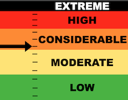
The majority of the terrain on the Manti Skyline has a LOW to MODERATE danger rating and human triggered avalanches are not very likely.
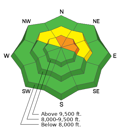
A CONSIDERABLE avalanche danger still exists in very steep upper elevation terrain that faces north, northeast and east where there is still a slim chance that a person could trigger a deep and dangerous avalanche.
Avoidance is key as there is no sure way to determine which slopes are stable and which are not.
Low
Moderate
Considerable
High
Extreme
Learn how to read the forecast here
Weather and Snow
Current Conditions: Temperatures were in the 50s again on Thursday. Wind was a bit breezy in the afternoon from the southwest. Overnight temperatures were in the 30s.
Mountain Weather: We'll see unsettled weather into next week. Expect clouds and the chance for very light precip, either rain or snow today. Temperatures will be a little cooler with highs in the 40s. Wind will be light to moderate in speed from the southwest. We'll see more of the same through the weekend.
Ad
Avalanche Problem #1
Persistent Weak Layer
Type
Location
Likelihood
Size
Description
There is still a small chance of triggering a deep and dangerous avalanche today. Unfortunately, the most likely places to do this are the exact places we often find ourselves at this time of the season: upper elevation north through east facing steep terrain.
The majority of the slopes will stay in place. Some will release if provoked. You will not see any signs of danger. The snowpack will feel stable and "bomber". There is no way to tell which slopes will stay in place and which ones might release if you get onto them. All you can do is avoid that terrain. Or roll the dice.
General Announcements
This forecast is from the U.S.D.A. Forest Service, which is solely responsible for its content. This forecast describes general avalanche conditions and local variations always occur.