Forecast for the Skyline Area Mountains

Brett Kobernik
Issued by Brett Kobernik for
Monday, March 27, 2023
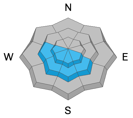
The snowpack is stabilizing but there is still a CONSIDERABLE danger rating for the upper elevation north through east facing slopes where recent drifts and slabs have formed.
All the new snow may become unstable if the sun heats it enough this afternoon.
Overall, you can travel around and easily avoid avalanche danger today. Just be mindful of the large drifts up high and watch out if the new snow gets wet and mushy.
Low
Moderate
Considerable
High
Extreme
Learn how to read the forecast here
Special Announcements
Drifting snow has closed State Road 31 from the top of Fairview Canyon (interstection of SR264) through Huntington Canyon to Crandall Canyon. It should reopen today.
Weather and Snow
Current Conditions: Riding conditions remain as good as they get with deep powder everywhere. It feels more like January than late March. Wind from the west was much lighter on Sunday than the previous few days. There was still a moderate breeze along the higher terrain and that is still the case this morning. Temperatures got into the low to mid teens Sunday and then dropped back to single digits overnight.

Mountain Weather: We should see the clouds break as the day goes on. Temperatures should get into the upper teens to low 20s today. Wind from the west and northwest should slow and shift more from the south. Tuesday looks warmer with partly cloudy skies. Another decent looking storm moves in late Wednesday and lasts into Friday which could produce a foot of snow.
Ad
Avalanche Problem #1
Wind Drifted Snow
Type
Location
Likelihood
Size
Description
All the drifts and slabs from the last windy storm should be stabilizing but I'm still not trusting them just yet. Continue to use caution in the upper elevation terrain where wind drifts and wind slabs have formed.
Avalanche Problem #2
Wet Snow
Type
Location
Likelihood
Size
Description
Wet snow avalanches following springtime storms is always a consideration. The new snow can become wet and unstable when the sun pops out. Even though temperatures should stay cold and we'll see some clouds, keep an eye out for the new snow to become unstable if the sun hits it. If you find yourself in wet, sloppy, mushy snow, it's time to start avoiding steep slopes, gullies and ravines.
General Announcements
This forecast is from the U.S.D.A. Forest Service, which is solely responsible for its content. This forecast describes general avalanche conditions and local variations always occur.