Forecast for the Skyline Area Mountains

Brett Kobernik
Issued by Brett Kobernik on
Friday morning, March 23, 2018

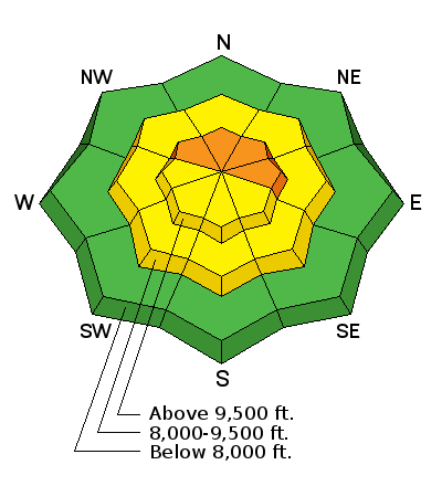
It is hard to say how the snowpack in the upper elevations reacted to the rain. I would still treat the upper elevation northwest through east facing steep terrain as being dangerous. I'm rating the danger as CONSIDERABLE in that terrain. I will have much better information on the current situation after doing fieldwork today.

Low
Moderate
Considerable
High
Extreme
Learn how to read the forecast here
Weather and Snow

The Skyline received rain up to at least 9700' Thursday afternoon and night. The entire snowpack was wet up to about that elevation. It's possible that it rained to 10,000'. Temperatures cooled slightly overnight and the rain turned to snow down to about 8500' with rain below that. There is about an inch of new snow in the higher terrain.

If you are thinking about getting into the hills, anticipate heavy dense snow and potentially unsupportable conditions under the new snow especially below about 9500' or so.

Ad
Additional Information

Issued by the National Weather Service:

Friday: Snow before noon, then a chance of snow showers after noon. High near 36. Breezy, with a west wind 13 to 22 mph. Chance of precipitation is 100%. New snow accumulation of 3 to 5 inches possible.
Friday Night: Partly cloudy, with a low around 23. Southwest wind around 9 mph becoming south southeast after midnight.
Saturday: A 20 percent chance of snow after noon. Mostly sunny, with a high near 36. South southwest wind 13 to 17 mph.
Saturday Night: Partly cloudy, with a low around 18. Breezy, with a southwest wind 16 to 22 mph.
Sunday: A 40 percent chance of snow after noon. Partly sunny, with a high near 29. New snow accumulation of less than one inch possible.
Sunday Night: A 40 percent chance of snow showers. Mostly cloudy, with a low around 11. New snow accumulation of less than a half inch possible.

General Announcements

Support the Utah Avalanche Center through your everyday shopping. DETAILS HERE

We will publish full detailed advisories Saturday and Sunday mornings by 7am. We will also be publishing basic avalanche danger ratings & info during the week.

If you are getting out into the mountains, we love to hear from you! You can SUBMIT OBSERVATIONS ONLINE or EMAIL US

If you would like to have avalanche advisories emailed to you, SIGN UP HERE

We can provide basic avalanche awareness presentations for your school, group or club. To enquire, CLICK HERE