Forecast for the Skyline Area Mountains

Brett Kobernik
Issued by Brett Kobernik on
Thursday morning, February 27, 2025
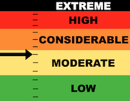
The majority of the terrain on the Manti Skyline has a MODERATE avalanche danger rating today.
Continue to use caution on steep north through east facing slopes where you could trigger an avalanche that breaks deep into weak loose sugary snow. Chances for triggering this type of avalanche are decreasing but the consequences remain high.
The snow is going to become wet in most locations today which can cause wet avalanche activity. That said, I don't think this is a real threat to people out there today. Just keep it in mind. It's always wise to move off steep slopes if you notice that you're sinking deep into sloppy wet snow.
Low
Moderate
Considerable
High
Extreme
Learn how to read the forecast here
Weather and Snow
Current Conditions: High temperatures reached about 30˚F on Wednesday and dropped back into the teens to low 20s overnight. Wind has been calm to light from the east. The snow conditions feel like they do in April. Most areas will be frozen this morning and will soften during the day with warming temperatures. Hints of dry dense cold snow are found on the highest northerly facing terrain.
Mountain Weather: We're sliding back into a warming trend that will last through the weekend. Today we'll have mostly clear skies with high temperatures reaching around 40˚F. Wind will be mostly light from the east becoming calm and variable in direction late this afternoon. Friday is similar only slightly warmer. Some clouds roll through this weekend with continued warm temperatures. The weather models are hinting at a more active pattern starting next week that could bring some fresh snow.
Ad
Avalanche Problem #1
Persistent Weak Layer
Type
Location
Likelihood
Size
Description
The warm temperatures are helping settle and stabilize the snowpack. The snowpack has settled at least 6 inches since the last storm. It is getting more unlikely that a person will trigger an avalanche that breaks deeper into faceted snow. However, this is still a distinct possibility. It's the nature of buried facets (loose sugary snow) to appear stable only to fail and release an avalanche when you least expect it.
So, lower chances for triggering an avalanche but consequences remain high. This is going to be the general trend through the weekend.
NOTE: There is a good chance that these buried weak layers will become more active again during and after future snow storms.
General Announcements
This forecast is from the U.S.D.A. Forest Service, which is solely responsible for its content. This forecast describes general avalanche conditions and local variations always occur.