Check out our Holiday Auction - Sign Up for the Utah Snow and Avalanche Workshop (USAW)

Forecast for the Skyline Area Mountains

Brett Kobernik
Issued by Brett Kobernik on
Saturday morning, February 10, 2024
The overall danger rating on the Skyline is rated CONSIDERABLE.
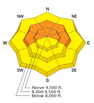
Human triggered avalanches involving the newer snow are possible today. The new snow is settling and stabilizing so I don't think this is a huge concern.
The danger revolves around a deeper avalanche that breaks into weak December snow. There is still a slight chance a person could trigger one of these. All the weight of the new snow has increased the chances.
Low
Moderate
Considerable
High
Extreme
Learn how to read the forecast here
Weather and Snow
Current Conditions: Another 1 to 3 inches of new snow stacked up in the last 24 hours. The wind is almost calm. Temperatures have plummeted into the single digits. Riding conditions are top notch.
Mountain Weather: This series of storms is basically over. There is some lingering moisture that may keep the mountains socked in with clouds today. However, there's a chance the clouds could start to break up as the day goes on. Temperatures will get into the mid teens. Wind will be light from the north northwest and may get slightly breezy later today. We're moving into a stretch of quiet weather with no significant storms expected through next week.
Ad
Avalanche Problem #1
New Snow
Type
Location
Likelihood
Size
Description
The new snow should be mostly stable and the likelihood of triggering an avalanche involving the upper layers of the snowpack is pretty low. I would still avoid places along the higher exposed terrain where the wind has drifted the new snow.
Avalanche Problem #2
Persistent Weak Layer
Type
Location
Likelihood
Size
Description
This avalanche problem is where the danger lies. Someone could still find a slope that will avalanche breaking into the Persistent Weak Layer near the ground. The weight of the new snow is stressing those old weak layers. Places with an overall shallower snowpack are the more likely places to trigger something. Steep rocky terrain is also another likely place to trigger one.
My guess is that after the snowpack adjusts to this new load, we may not have to worry anymore about avalanches breaking deep. We'll see..........
General Announcements
This forecast is from the U.S.D.A. Forest Service, which is solely responsible for its content. This forecast describes general avalanche conditions and local variations always occur.