Forecast for the Skyline Area Mountains

Brett Kobernik
Issued by Brett Kobernik for
Monday, December 31, 2018
The avalanche danger is MODERATE especially in areas that received up to 1 foot of snow overnight. The new snow may be sensitive today and human triggered avalanches possible. Watch for cracking within the new snow which would indicate things are sensitive. Use "ski cuts" and "sidehill" small test slopes to try to initiate cracking so you get a handle on the sensitivity of the new snow. The new snow should stabilize fairly rapidly but I'd give it a day before really trusting it.
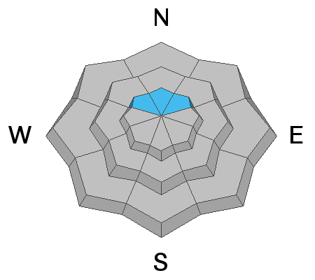
In areas that received the most new snow AND have old weak sugar snow near the ground (steep north facing slopes above 9500'), there is a chance a person could trigger a large and dangerous avalanche.
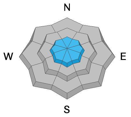
Low
Moderate
Considerable
High
Extreme
Learn how to read the forecast here
Weather and Snow
A storm rolled through over the last 12 hours bringing snow to the Skyline. Totals vary greatly by location. The top of Fairview Canyon only has picked up a few inches of new snow. The central Skyline from about Pleasant Creek through Ephraim Canyon has picked up 1 foot of new snow! (see video below) The southern end of the Skyline only received 2 to 4 inches. The wind has been very well behaved during this storm and generally light from the northwest. Overnight temperatures were in the single digits again. We may see a bit more snow today as the storm lingers but it shouldn't accumulate a whole lot more. Things clear out for the remainder of the week and temperatures will warm starting Wednesday. The next storm is shaping up for Sunday into early next week.
Ad
Avalanche Problem #1
New Snow
Type
Location
Likelihood
Size
Description
Your main concern today is in areas that received up to a foot of new snow. Anytime snow stacks up quickly, it can be sensitive. It's hard to say just how sensitive the new snow will be today but it did stack up fast overnight. One good thing is the wind has been generally light so there won't be much drifting of the new snow. Generally, when the new snow is sensitive, it's easy to tell because it will often crack immediately when it's disturbed by a sled or skis.
Avalanche Problem #2
Persistent Weak Layer
Type
Location
Likelihood
Size
Description
There is a slight chance that the new snow has overloaded the snowpack enough where a person could trigger an avalanche that breaks into loose sugary snow near the ground. This is fairly unlikely and limited to the higher northerly facing slopes that have loose sugar snow near the ground from very early in the winter. My gut tells me this won't be a major concern but I do know there is enough loose sugar snow near the ground in those higher northerly slopes to make me uncomfortable. As we continue to stack snow onto the snowpack, that loose sugar snow near the ground will continue to become stronger. I just don't think it should be trusted just yet.
Additional Information
This forecast is from the U.S. Forest Service, which is solely responsible for its content. This forecast describes general avalanche conditions and local variations always occur.