Join us at our 2nd Annual Blizzard Ball

Forecast for the Skyline Area Mountains

Brett Kobernik
Issued by Brett Kobernik on
Thursday morning, December 19, 2024
The avalanche danger on the Manti Skyline is rated MODERATE.
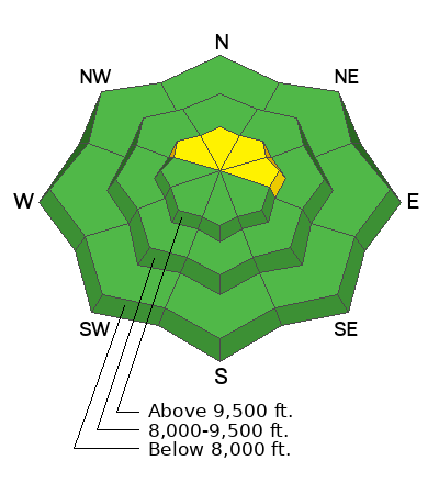
The main avalanche threat is the chance for triggering a drift or slab that formed from recent strong wind.
The most likely places to still trigger one of these is on very steep upper elevation slopes right near the ridges that face northwest through east.
The chances for triggering one of these decreases slightly each day.
Low
Moderate
Considerable
High
Extreme
Learn how to read the forecast here
Special Announcements
Now is a great time to dial in your safety gear including putting fresh new batteries in your beacons! Local shops across the state will be handing out free Batteries for Beacons now until February 1, 2025. All you need to do is fill out a quick survey and grab the AAA or AA batteries you need to keep your beacon fresh this season. Find participating shops and MORE INFO HERE.
Weather and Snow
Current Conditions: There is not much to talk about right now. Riding conditions are generally poor. The snowpack is still quite shallow. High temperatures have been into the upper 30s and wind from the west has been light to moderate in speed.
Mountain Weather: High pressure continues to be the dominant feature into the weekend. Expect clear skies, high temperatures into the upper 30s or low 40s and light west wind today. The pattern looks similar into the weekend although we may see a bump in wind speeds on Friday.
Recent Avalanches
These avalanches that released on Sunday demonstrate the kind of situation you'll want to watch out for today.
Pleasant Creek, 3rd large path
Pleasant Creek, BBQ Bowl
Ad
Avalanche Problem #1
Wind Drifted Snow
Type
Location
Likelihood
Size
Description
You'll find cornices, drifts and slabs along the higher ridges. Most of these will be pretty stubborn to crack out at this point. However, there's still a chance. The most likely places to trigger something today is on very steep upper elevation slopes that face north through east right below the ridges. These are the places where the drifts and slabs have formed on top of older weak sugary snow which makes them more unpredictable.
General Announcements
This forecast is from the U.S.D.A. Forest Service, which is solely responsible for its content. This forecast describes general avalanche conditions and local variations always occur.