Forecast for the Skyline Area Mountains

Brett Kobernik
Issued by Brett Kobernik for
Tuesday, December 14, 2021
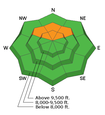
There is a CONSIDERABLE danger in mid and upper elevation northeast, north and northwest facing slopes that received around a foot of wind drifted snow on Thursday. Human triggered slab avalanches are likely on these slopes. Southwest wind will continue to drift snow and enhance the danger.
Continue to avoid steep upper elevation NE, N and NW facing slopes until we see improved snow stability.
Low
Moderate
Considerable
High
Extreme
Learn how to read the forecast here
Special Announcements
Get free batteries for your transceiver and a chance to win 1 of 10 Black Diamond Rescue Kits, 1 of 3 Mammut Barryvox transceivers, or 1 of 3 BCA Tracker transceivers. Stop at Big Pine Sports in Fairview or another participating shop, fill out our survey and get a free set of batteries. Don't need batteries, but still want a chance to win? Simply fill out the survey to be registered.
Weather and Snow
Mountain Weather
Today will be cloudy with mild temperatures and moderate to strong southerly wind. A pretty decent little storm will move through tonight and end Wednesday morning. I'm thinking we should see around 8 inches of new snow. A bit more is possible. Wind will be strong from the southwest switching northwest overnight. The storm starts out warm with much colder air moving in overnight. Another little impulse will move through on Thursday which looks like it may add a few additional inches of snow.
Ad
Avalanche Problem #1
Persistent Weak Layer
Type
Location
Likelihood
Size
Description
A layer of sugary faceted snow from October storms is acting as a persistent weak under the newest storm snow. Human triggered slab avalanches are likely in the right locations. This problem exists above about 9000' in elevation on northeast, north and northwest facing slopes steeper than 35 degrees.