Forecast for the Skyline Area Mountains

Sunday morning, January 31, 2016
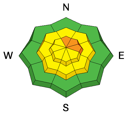
The majority of the terrain has a LOW to MODERATE avalanche danger. However, a CONSIDERABLE avalanche danger does exist in the higher steep north through east facing terrain. The danger will increase into Monday if we get the high end of the forecast snow totals.
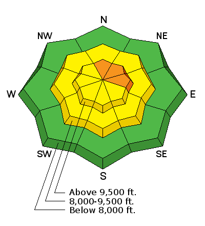
Persistent Weak Layer


Description
The new snow won't have changed the avalanche conditions much. There is still a chance that you could trigger a slide that breaks into deeply buried weak layers in the steep north through east facing higher terrain.
Additional Information
We're going to have a cloudy day today as the next storm approaches. Ridgetop high temperatures should be around 20 and westerly winds will remain fairly light. We'll see some snowfall but not much accumulation will add up until tonight and Monday. Wind speeds shift east for a period overnight and then get a bit breezy from the north on Monday. It's looking like we could see another 6 to 12 inches of snow by the time the storm winds down on Tuesday morning.
General Announcements
We will publish full detailed advisories Saturday and Sunday mornings by 7am. We will also be publishing basic avalanche danger ratings & info during the week.
If you are getting out into the mountains, we love to hear from you! You can SUBMIT OBSERVATIONS ONLINE or EMAIL US
If you would like to have avalanche advisories emailed to you, SIGN UP HERE
We can provide basic avalanche awareness presentations for your school, group or club. To enquire, CLICK HERE