Forecast for the Skyline Area Mountains

Brett Kobernik
Issued by Brett Kobernik for
Tuesday, January 22, 2019
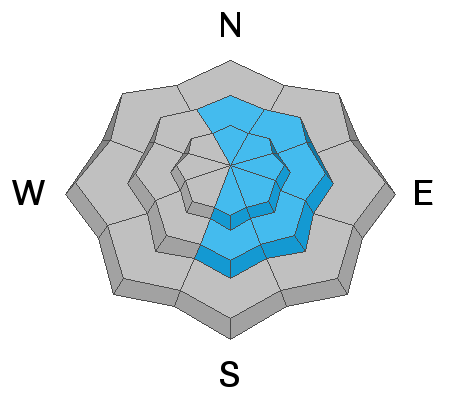
The avalanche danger is HIGH today. Travel in avalanche terrain is not recommended. Stay off of and out from underneath all slopes that are 30 degrees or steeper.
It is definitely not the day to play on or near any steep slope.
Low
Moderate
Considerable
High
Extreme
Learn how to read the forecast here
Avalanche Warning
AN AVALANCHE WARNING CONTINUES FOR THE MANTI SKYLINE, where heavy snowfall and strong winds have created a HIGH avalanche hazard. Human triggered avalanches are very likely, and natural avalanches are possible. Avoid being on and underneath slopes steeper than 30 degrees, and avoid avalanche runout zones.
Weather and Snow
About a foot of snow has stacked up in the last 24 hours. The wind was blowing the snow all over the place last night but has been slowing down. Temperatures have dropped into the single digits.
Ad
Avalanche Problem #1
Wind Drifted Snow
Type
Location
Likelihood
Size
Description
Wind drifting the new snow will be the biggest cause for avalanches today. You'll find drifts all over the place but it'll be most dangerous on slopes that have some sort of east facing component. Below are some photos of clues to how the wind has been transporting snow.
Snow getting blown sideways. It should be obvious that the snow is getting blown rather than falling straight out of the sky.
This photo is at my weather station in Spring City Canyon. Usually the snow is smooth on the storm board. This tells me that snow was really getting blown around.
Additional Information
This forecast is from the U.S. Forest Service, which is solely responsible for its content. This forecast describes general avalanche conditions and local variations always occur.