Join us at our 2nd Annual Blizzard Ball

Forecast for the Skyline Area Mountains

Brett Kobernik
Issued by Brett Kobernik on
Thursday morning, January 16, 2025
.
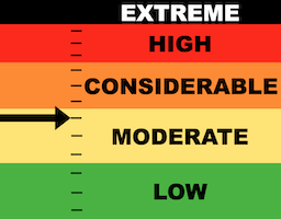
We are at the upper end of the MODERATE danger rating.
Chances for triggering an avalanche are becoming low but if something releases, it will most likely break a couple of feet deep.
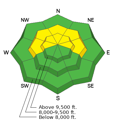
The most likely places to trigger something are on slopes steeper than 30˚ above 8000 feet in elevation on slopes that face west, north and east.
Low
Moderate
Considerable
High
Extreme
Learn how to read the forecast here
Special Announcements
FREE BEACON CLINIC
Saturday, 8:30am to 1 pm
North Skyline Drive trailhead at the intersection of State Road 31 and State Road 264, north side of the parking lot.
Show up anytime between 8:30 and 1 and we will teach you how to use your rescue gear. You will feel MUCH MORE CONFIDENT with your rescue gear after this session.
Weather and Snow
Current Conditions: It was a very nice day in the mountains on Wednesday with mostly clear skies and temperatures into the mid to upper 30s. Wind was light from an east direction. It is still light but has switched and is from the southwest this morning. Riding conditions are decent. I find that skiing/snowboarding is better than snowmachines right now because on skis, the snowpack is supportable and you stay up on top. On snowmachines, there are many places where you still punch deep into the pack. This requires conservative riding. MORE DETAILS HERE.
Mountain Weather: Today looks like it'll be the warmest day this week with temperatures in the higher terrain getting into the upper 30s and low 40s. Wind will remain fairly light from the northwest. We'll see a few more clouds on Friday with a bump in wind speed then a small chance for a few snowflakes on Saturday. The long term through the end of the month looks grim for snowfall.
Ad
Avalanche Problem #1
Persistent Weak Layer
Type
Location
Likelihood
Size
Description
You probably won't experience any collapsing or "whumpfing" of the snowpack underneath you at this time. You most likely won't see any recent avalanches. These two clues are the biggest indicators of unstable snow and the snowpack is, no doubt, settling and stabilizing. For the moment.
But the buried weak faceted snow at the base of the snowpack remains the focus. It should be quite obvious that the weak snow is there. You'll probably notice that you can easily "trench" your machine to the ground in many locations still. Step off your machine or skis and you will punch through deep into the pack in lots of areas. These are the big clues pointing to weak snow right now.
What most likely will happen is that the weak layers will go "dormant" and be non-reactive as more time goes by. But will they awaken again and become really dangerous? That will depend on what the weather delivers.
We are not out of the woods. Things are precarious and I'm holding my cards tight.
.
General Announcements
This forecast is from the U.S.D.A. Forest Service, which is solely responsible for its content. This forecast describes general avalanche conditions and local variations always occur.