Join us at our 2nd Annual Blizzard Ball

Forecast for the Skyline Area Mountains

Brett Kobernik
Issued by Brett Kobernik on
Friday morning, January 17, 2025
.
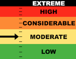
Today's danger rating on the Manti Skyline is MODERATE.
Human triggered avalanches are possible but are becoming less likely.
Steep wind loaded slopes above 8000 feet in elevation that face west, north and east are the most likely places to find trouble.
Low
Moderate
Considerable
High
Extreme
Learn how to read the forecast here
Special Announcements
FREE BEACON CLINIC
Saturday, 8:30am to 1 pm
North Skyline Drive trailhead at the intersection of State Road 31 and State Road 264, north side of the parking lot.
Show up anytime between 8:30 and 1 and we will teach you how to use your rescue gear. You will feel MUCH MORE CONFIDENT with your rescue gear after this session.
Weather and Snow
Current Conditions: Wind from the west has increased in speed overnight and is in the moderate speed category with stronger speeds on the most exposed peaks. It is still light down in the canyons. Temperatures peaked near 40˚F on Thursday and have dropped into the low to mid 20s overnight. Riding conditions remained good on Thursday although still "punchy" in many places on machines.
Mountain Weather: We'll see some scattered clouds moving through as the day goes on. Wind from the west will gradually start to increase through the day. High temperatures will get into the upper 20s. The wind gets strong tonight as a weak storm system moves through bringing minor amounts of snow. Saturday looks cloudy and northwest wind should decrease as the day goes on. No significant storms are in sight.
Ad
Avalanche Problem #1
Persistent Weak Layer
Type
Location
Likelihood
Size
Description
The overall stability of the old buried Persistent Weak Layers is increasing. There have been no recent avalanches that I know of. Collapsing (whumpfing of the snow underneath you) is uncommon now. I haven't experienced a "whump" in over a week. I have not been experiencing any cracking as I travel through the snow. Snow pit stability tests are not failing. The only red flag is "poor snowpack structure". You will no doubt find many areas where you punch through into sugary facets. However, they do seem to be stabilizing and the chance for triggering an avalanche is becoming less.
The most likely spots a person might trigger an avalanche today is where the wind has drifted and deposited snow forming slabs. If you avoid places that have obvious pillows, drifts or slabs, you will most likely be safe today.
.
General Announcements
This forecast is from the U.S.D.A. Forest Service, which is solely responsible for its content. This forecast describes general avalanche conditions and local variations always occur.