Forecast for the Skyline Area Mountains

Saturday morning, January 16, 2016
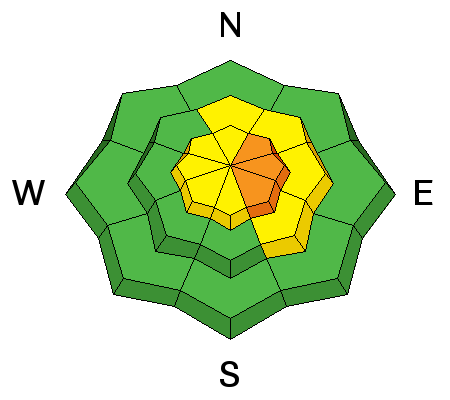
The majority of the terrain in the mountains is fairly safe with a LOW to MODERATE avalanche danger. The danger is more pronounced along the higher more east facing terrain where the wind has deposited the new snow and formed drifts that will likely be sensitive to a person or a rider. THE DANGER WILL BE INCREASING DURING THE DAY. Watch for cracking in the snow as you travel and avoid any obvious wind pillows on along the upper ridges.
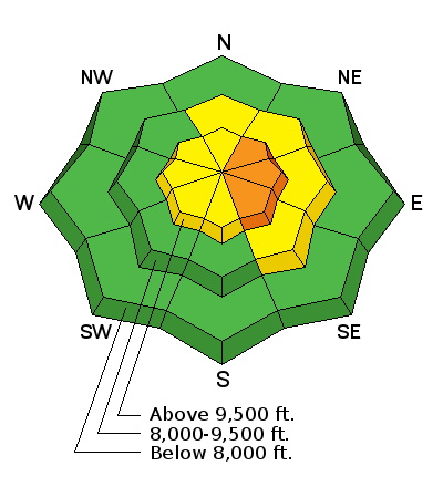
Weather and Snow
The Skyline picked up 4 to 8 inches of new snow on Friday. West northwest winds were slightly gusty along the ridges. They remain gusty this morning in the higher terrain. Temperatures this morning are in the teens. Riding conditions are good.
Along the higher terrain, the wind was drifting snow on Friday and created some fresh drifts that could have pushed around a skier, snowboarder or snowshoer. They didn't appear large enough to really cause much harm to a snowmobiler.
Click HERE for some more detailed thoughts on the current snowpack situation.
Below are some observations from Friday:
Region | Occurence Date | Type/Location | Name | |
---|---|---|---|---|
Skyline | 01/15/2016 | Observation: Ephraim Canyon | Darce Trotter / Steve Cote | Details |
Skyline | 01/15/2016 | Observation: Spring City Canyon | Kendall/Kobernik | Details |
Wind Drifted Snow


Description
Recent deposits of wind drifted snow is your main concern out there today. West northwest wind has been drifting snow onto the more east facing slopes. This will continue today. There will also be more snow falling later today. The new snow will be higher density than Friday's and this might enhance the sensitivity of the wind slabs. These drifts might get large enough today to be dangerous.
Additional Information
We'll have mostly cloudy skies today with another small storm moving in late morning which should produce some snow into the afternoon. It looks like a 3 to 5 inch snow event. Densities will be higher than Friday's snow. Northwest wind will continue to be a gusty today along the ridges. Temperatures will get into the mid 20s along the higher terrain. We might see a little clearing Sunday afternoon and then another small storm rolling in later Monday. Temperatures will be warmer through that period with highs in the upper 20s.
General Announcements
We will publish full detailed advisories Saturday and Sunday mornings by 7am. We will also be publishing basic avalanche danger ratings & info during the week.
If you are getting out into the mountains, we love to hear from you! You can SUBMIT OBSERVATIONS ONLINE or EMAIL US
If you would like to have avalanche advisories emailed to you, SIGN UP HERE
We can provide basic avalanche awareness presentations for your school, group or club. To enquire, CLICK HERE