Forecast for the Skyline Area Mountains

Monday morning, January 15, 2018
Chances of triggering an avalanche are decreasing as more time since the last storm passes. However, the avalanche danger remains CONSIDERABLE on the steep west, north and east facing slopes above around 9000' or so. Buried faceted (sugar) snow is nothing to toy with and will often cause avalanches long after we think it can.
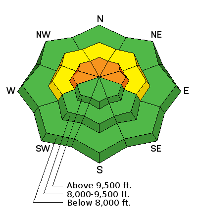
Special Announcements
Be sure to join us at Big Pine Sports on Thursday, January 25th for a free avalanche presentation. DETAILS HERE
We are offering a Motorized Backcountry 101 avalanche class on February 10th. DETAILS HERE
Weather and Snow
It was another pleasant day in the mountains on Sunday with mild temperatures and light wind. Riding conditions remain good in settled powder on the shady aspects. Unfortunately, this is where you can still find avalanche trouble. Continue to keep your slope angles low if you are in the upper elevation more northerly facing terrain. If you experience collapsing or cracking of the snowpack, this is mother nature warning you about avalanche danger.
Additional Information
General Announcements
Support the Utah Avalanche Center through your everyday shopping. DETAILS HERE
We will publish full detailed advisories Saturday and Sunday mornings by 7am. We will also be publishing basic avalanche danger ratings & info during the week.
If you are getting out into the mountains, we love to hear from you! You can SUBMIT OBSERVATIONS ONLINE or EMAIL US
If you would like to have avalanche advisories emailed to you, SIGN UP HERE
We can provide basic avalanche awareness presentations for your school, group or club. To enquire, CLICK HERE