Join us at our 2nd Annual Blizzard Ball

Forecast for the Skyline Area Mountains

Brett Kobernik
Issued by Brett Kobernik on
Friday morning, January 10, 2025
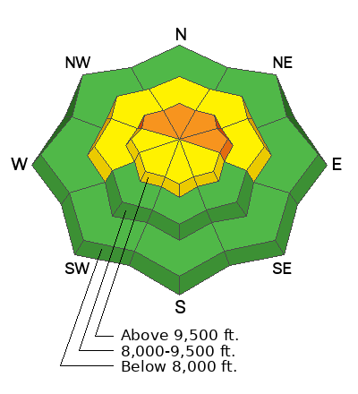
The overall danger rating remains CONSIDERABLE today on the Manti Skyline on steep upper elevation slopes that face northwest through east.
While becoming less likely, human triggered avalanches breaking into old weak sugary snow are still a major concern.
Slab avalanches that break into buried facets cause the most avalanche fatalities in Utah. It is best to avoid steep terrain until we see improvement in the snowpack structure.
Low
Moderate
Considerable
High
Extreme
Learn how to read the forecast here
Special Announcements
GET TEXT MESSAGES about changing avalanche conditions and avalanche warnings. Sign up and update your preferences HERE.
FREE AVALANCHE AWARENESS PRESENTATION!!
Big Pine Sports
340 N Milburn Rd, Fairview, UT 84629
Tuesday, January 14th, 7pm
Weather and Snow
Current Conditions: It was another cold night with many locations again dipping into the single digits. Wind has shifted from the east and is now coming from the west. It is in the light to moderate speed categories. I found very good skiing conditions on Thursday but you'll also find many areas where the wind has created varying crusts that aren't all that fun.
Mountain Weather: We'll see temperatures warm into the mid to upper 20s today. Skies should be mostly clear this morning with clouds moving in this afternoon. Light to moderate speed wind will be from the northwest. It may feel slightly breezy along the more exposed terrain. A storm moves in tonight and will linger through the weekend bringing 2 to 4 inches of snow, perhaps up to 6 if we're lucky.
Ad
Avalanche Problem #1
Persistent Weak Layer
Type
Location
Likelihood
Size
Description
Same old story. Buried layers of weak faceted snow are still the main concern. These Persistent Weak Layers have not gained enough strength yet to dismiss them. Avalanches breaking into the buried weak layers can still be triggered by people. Very steep slopes on the more northerly half of the compass are the most likely places to trigger something.
We really need to add more layers of snow onto our existing snowpack to help compress and strengthen the old weak facets at the base. The bummer is that new snow amounts look pretty bleak over the next few weeks. I fear we'll be focusing on these old weak layers for some time to come.
.
General Announcements
This forecast is from the U.S.D.A. Forest Service, which is solely responsible for its content. This forecast describes general avalanche conditions and local variations always occur.