Forecast for the Salt Lake Area Mountains

Trent Meisenheimer
Issued by Trent Meisenheimer on
Saturday morning, April 5, 2025
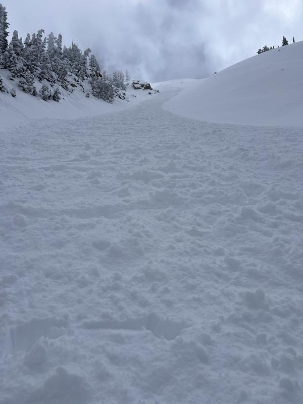
The avalanche danger is MODERATE on all aspects across the upper elevations where humans can trigger avalanches involving long-running sluffs and shallow soft slabs of new snow. These avalanches could be 1 to 2 feet deep and up to 150 feet wide.
On slopes facing east, southeast, south, southwest, and west, the avalanche danger for wet snow will quickly rise to MODERATE and could rise to CONSIDERABLE as strong sunshine and warming temperatures heat the snow, making it unstable.
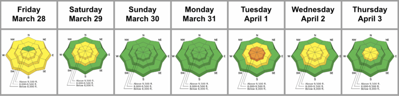
Low
Moderate
Considerable
High
Extreme
Learn how to read the forecast here
Special Announcements
Motorized Users—Please consider taking this 5-minute survey to help researchers better understand avalanche education participation and safety preparedness. Responses are anonymous and confidential.
Weather and Snow
Under clear skies, the mountain temperatures are cold and range from 10-16 °F. The northeast wind blows 5-10 mph, with gusts trying to hit 20 mph across most of the upper elevation terrain. Today, we can expect plenty of sunshine, with temperatures climbing into the upper 30s to low 40s °F.
Excellent riding and turning conditions exist with 1 to 2 feet of powder snow on most aspects and elevations from the past week of storms. Get it before the sun does.
Recent Avalanches
Several avalanches were reported to the UAC yesterday, with two people caught and carried by the avalanche. Luckily, nobody was injured. These avalanches were soft slab avalanches failing within the new snow due to density changes. Most were 12-18 inches deep, and one was 150 feet wide. See the list:
  • Avalanche, LLC, Birthday Chutes 12 inches deep, 35 feet wide, caught and carried (Picture Below).
  • Avalanche, BCC, Meadow Chutes, caught and carried. This was second-hand information. I'm unsure of the dimensions.
  • Avalanche, BCC, Wolverine Cirque, 18 inches deep, 150 feet wide, remotely triggered.
  • Avalanche, Mineral Basin, Sinners Pass, 12 inches deep, 30 feet wide, broke at their feet.
Ad
Avalanche Problem #1
New Snow
Type
Location
Likelihood
Size
Description
The 18-36" of new snow we've received this week may be reactive today in the following ways:
1. New Snow: Sluffing and shallow soft slabs of new snow failing in different density inversions within the storm snow. These avalanches have been 1-2 feet deep and up to 150 feet wide. Use slope cuts before committing to steep terrain, and only expose one person at a time to avalanche terrain.
2. Wind-Drifted Snow: The wind has been almost non-existent. However, I would always be on the lookout for slopes with recent drifts of wind-blown snow. Terrain selection will increase or decrease the consequences of being caught in small avalanches.
Avalanche Problem #2
Wet Snow
Type
Location
Likelihood
Size
Description
It's been a cold week with plenty of dry cold snow on all aspects and elevations. Today, we will see plenty of strong sunshine and warming temperatures hitting the cold dry snow for the first time. I am unsure just how quick or reactive this cold snow will become. However, I do know that today is NOT the day to be on or under steep sunny terrain.
Remember, if the snow is becoming damp and you're seeing roller balls on any aspect or elevation it's time to get out of there. Plan your exits today and remember the aspects above you can be cooking in the sun while you're in the shade below. Wet snow avalanches can run long distances and pile up deeply in gullies and other terrain traps.
Video (Wares): This was from April 2nd. However, it demonstrates the dangers of wet snow.
Additional Information
It has been a snowy week, and Nikki describes it in more detail in the Week in Review.
General Announcements
This information does not apply to developed ski areas or highways where avalanche control is normally done. This forecast is from the U.S.D.A. Forest Service, which is solely responsible for its content. This forecast describes general avalanche conditions and local variations always occur.