Forecast for the Salt Lake Area Mountains

Greg Gagne
Issued by Greg Gagne for
Friday, April 5, 2024
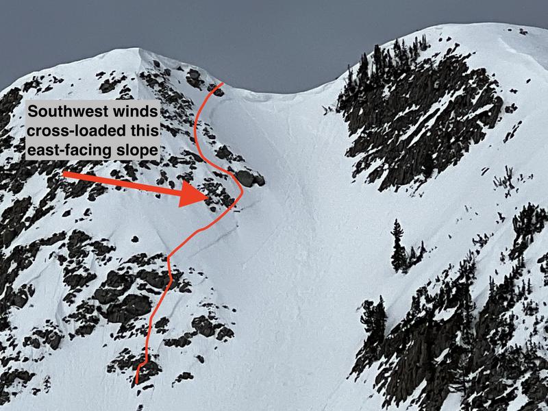
The avalanche danger is LOW, but could rise to MODERATE during the afternoon as gusty winds drift new snow into shallow soft slabs of wind-drifted snow at the mid and upper elevations.

Expect a rising avalanche danger this weekend with winds and periods of heavy snow.
Low
Moderate
Considerable
High
Extreme
Learn how to read the forecast here
Special Announcements
Support the UAC website backend platform to ensure the ongoing security of the website and the data stored on the site rebuild by donating to our spring campaign.

Do We Let Our Guard Down in the Spring? --- UAC Avalanche Education coordinator McKinley Talty looked at the numbers....and his blog just might surprise you.
Weather and Snow
This Morning: Skies are overcast and temperatures are 30-35° F. Winds are from the south and have been moderate to strong for the past 36 hours, with gusts 30-50 mph through the mid and upper elevations.
Today: Continued moderate to strong southerly winds, with snowfall developing by early afternoon as a cold front enters the region. Temperatures will rise this morning into the upper 30's and low 40's F, but begin dropping during the afternoon. 2-4" of new snow is possible by 6 pm.

This Weekend: Saturday will feel closer to January - not April - with temperatures in the teens and 20's F and gusty northwest winds. Snowfall totals could approach - and possibly exceed - two feet in areas favored by a northwest flow by Sunday.
Recent Avalanches
Cloud cover and winds kept the snow surface cool on Thursday which minimized wet avalanche activity. In my field day on Thursday in upper White Pine, longtime ski partner Rob Frey and I found not only poor skiing, but a few recent avalanches below Lake Peak on slopes that were wind-loaded from strong winds this past weekend.
This photo shows the outline of a crown on east-facing Lake Chute. This slope was cross-loaded from southwest winds. With continued winds and periods of heavy snow forecast this weekend, we can expect to see similar avalanches such as this.

Check out all avalanches and observations HERE.
Ad
Avalanche Problem #1
Normal Caution
Type
Location
Likelihood
Size
Description
Despite the low avalanche danger, there is an inherent risk when traveling in avalanche terrain, and the things to watch for today include:
1. Wet-loose avalanches in wind-sheltered terrain, especially at low elevations.
2. Winds may drift snow into shallow wind drifts, especially as snowfall develops this afternoon.
3. Cornices are large and adorn many ridgelines. Warm temperatures may make cornices more prone to collapsing naturally onto slopes below.
General Announcements
This information does not apply to developed ski areas or highways where avalanche control is normally done. This forecast is from the U.S.D.A. Forest Service, which is solely responsible for its content. This forecast describes general avalanche conditions and local variations always occur.