Forecast for the Salt Lake Area Mountains

Trent Meisenheimer
Issued by Trent Meisenheimer for
Tuesday, April 27, 2021
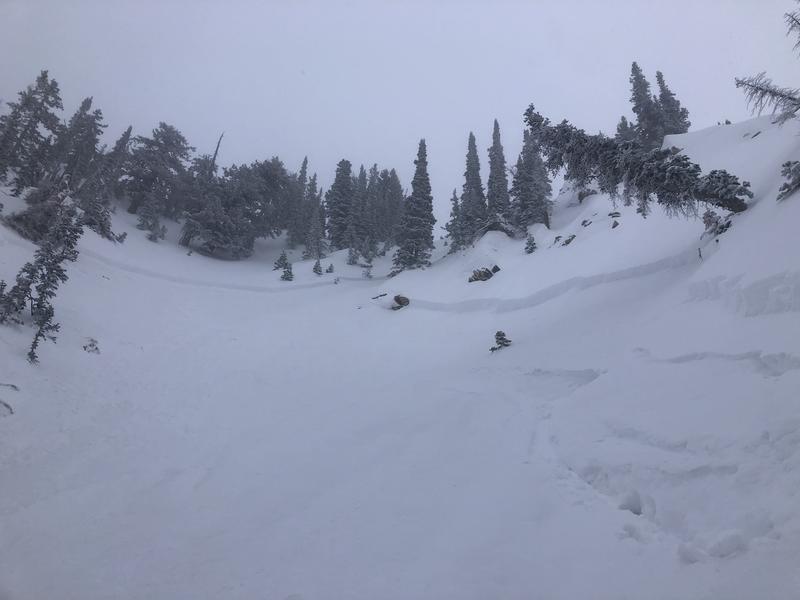
Strong winds and heavy snowfall has created areas of unstable snow throughout the Wasatch Range. Be on the lookout for areas that have been loaded by the strong southerly winds and avoid those slopes. Soft slab human triggered avalanches 12 inches deep and up to 60-100 feet wide will remain possible today. Evaluate the snow and terrain carefully; look for and avoid features of concern.
If the sun decides to show its face today, remember that it's almost May, and it will only take minutes to make the snow unstable on steep, sunlit aspects.

During the spring, we typically deal with three different avalanche problems:
1. Wet snow: Wet loose avalanches, wet slab avalanches, and lastly, glide avalanches.
2. New snow: New storm snow instability as soft slab avalanches and loose dry avalanches.
3. Wind Drifted Snow: Wind slabs - soft or hard drifts of wind-blown snow.
Low
Moderate
Considerable
High
Extreme
Learn how to read the forecast here
Special Announcements
Regular avalanche forecasts with avalanche danger ratings have ended, and we will no longer be updating this page. We will continue to post all observations, so please keep submitting them as you get out in the mountains. Greg Gagne will update the snow and weather by 7:00 am Wednesday, April 28th.
Weather and Snow
Yesterday's moist storm delivered strong southerly winds for most of the day, with speeds averaging 15-25 mph gusting into the 40's across the upper elevations for much of the day. Snow totals are roughly 11.5 inches of snow with 1.57 water in the Upper Cottonwoods. If you lose some elevation, the snow totals drop dramatically, with mid-Big Cottonwood coming in at 4.5 inches snow with 0.94 water. Outside of the Upper Cottonwoods, snow totals are 2-3 inches with 0.50 water.
Around 5:00 pm yesterday, the winds finally veered to the northwest and decreased to speeds of 5-10 mph through the overnight hours. This morning, the winds remain from the northwest at speeds of 5-10 mph across much of the upper elevation ridgelines. At the top of Hidden Peak (11,000'), the winds blow northwest at 10-15 mph gusting 21 mph. Under partly cloudy skies, the mountain temperatures are 18-25°F.
Today we should see the clouds fill back in quickly with the chance of some afternoon mountain snow showers above about 6,000' as the last gasp of this storm crosses Northern Utah. High pressure will quickly build in for the remaining part of the week with a warming trend before cooling off again next week.
  • A full list of mountain weather stations can be found HERE.
Recent Avalanches
Yesterday's strong winds and heavy snowfall were enough to make some slopes reactive to the weight of riders. In upper days several groups reported avalanches with one person on the slope triggering an avalanche. In upper Scotties, in Little Cottonwood, another rider triggered an avalanche in a steep wind-loaded slope. In total, we had roughly seven human-triggered slides yesterday. These avalanches roughly failed 8-12 inches deep, 60-100 feet wide, with some running 500 vertical feet down the slope. I would encourage you to look through the snow and avalanche observations with the link below:
  • A list of all observations and avalanches can be found HERE.
Avalanche in Scotties Bowl in Upper Little Cottonwood (Photo: Sean)
Ad
Avalanche Problem #1
New Snow
Type
Location
Likelihood
Size
Description
We almost always get several winter-like snow storms in April and May. Treat each storm just like you would in winter. Avalanches can occur within the new snow typically from 1) low-density layers deposited during the storm, 2) high precipitation intensity during a storm, and 3) from wind slabs created during the storm.
It's easy to test the new snow as you travel by jumping on small test slopes to see if they avalanche or dig down with your hand to see how well the new snow is bonding. Snow can change dramatically in both space and time, so never let your guard down. Especially avoid any steep slope with recent wind deposits, which are almost always dangerous.
Practice the usual backcountry protocol, go one at a time, never travel above other people and practice all the usual risk reduction measures and low-risk travel rituals you learn in avalanche classes.
Avalanche Problem #2
Wind Drifted Snow
Type
Location
Likelihood
Size
Description
It will be worth looking at the winds for each storm to find out which direction they have blown from and what direction they will be blowing for the day. Wind can rapidly load snow onto steep slopes, making those slopes more prone to avalanching. The wind drifted snow looks rounded and pillowy; it can sound hollow like a drum in some cases. If you see shooting cracks, it's a sign you may have hit a wind slab. Be sure to click on this link HERE (click on Wx Stations) and check upper elevation winds for speed and direction.
Additional Information
Learn what to watch for during spring avalanche conditions when the snow becomes wet with this video from the UAC.
Thanks to all of you who have sent observations this season. Crowd-sourcing is the most valuable information we get. Other avalanche centers all over the world are modeling our program. And special thanks to all the Utah avalanche professionals: ski areas, Utah Department of Transportation, guides, and educators, Powderbirds and Park City Powder Cats.
Thanks to Rusty Billingsley and the National Weather Service who provide office space, weather forecasting, tech support, and great company.
A special thanks to all of you who donate directly to the Utah Avalanche Center. We couldn't do this without your support.

Ski areas are closed, and each has a different uphill travel policy. Remember that areas open to uphill travel are no longer doing any avalanche mitigation work and must be treated as backcountry terrain.
Be sure to mark your calendars - join us for the 27th Annual Fall Party at Black Diamond on Thursday, September 10th, and the 13th Annual Utah Snow and Avalanche Workshop at Mountain America Expo Center Saturday, November 6-7.
The Utah Avalanche Center is a partnership between the Forest Service and the non-profit Utah Avalanche Center. On the Forest Service side, thanks to unwavering support from our boss Renee Flanagan, Forest Supervisor Dave Whittekiend, the rest of the Uinta-Wasatch-Cache National Forest, Brian Murdock of the Manti-La Sal National Forest, and the financial support from Chris Hartman of the Forest Service Intermountain Region. Two-thirds of the Utah Avalanche Center funding, along with the awareness and education programs, comes from the non-profit Utah Avalanche Center. Our forecast staff includes Director Mark Staples, Drew Hardesty, Toby Weed, Craig Gordon, Brett Kobernik, Eric Trenbeath, Trent Meisenheimer, and Nikki Champion. Our nonprofit staff includes Executive Director Chad Brackelsberg, Greg Gagne, Paige Pagnucco, Andy Nassetta, Hannah Whitney, and Christian Raguse. Our interns this year include Francine Mullen, Joey Manship, and McKinley Talty. Board of Directors Kate Bowman, Ted Roxbury, Michael Brill, Al Richards, Tyler Hansen, Nicole Sumner, Caitlin Hansen, Jacob Splan, Rich Mrazik, Eric Quilter, Kim Reid, Michael Shea, Dara Cohen, Sara Gibbs, TJ Kolanko, and Christian Schauf.

Direct funding comes from longtime partners, Utah Division of Parks and Recreation, Utah Division of Emergency Management, Utah Department of Transportation and Salt Lake County.
Generous support in the form of donated lift tickets and daily observations comes from Ski Utah, Alta, Brighton, Beaver Mountain, Deer Valley, Powder Mountain, Snowbasin, Snowbird, and Solitude.

Business sponsors who donate to the Utah Avalanche Center are too numerous to list here, but you can find them on our Sponsors Page.
General Announcements
This information does not apply to developed ski areas or highways where avalanche control is normally done. This forecast is from the U.S.D.A. Forest Service, which is solely responsible for its content. This forecast describes general avalanche conditions and local variations always occur.