Forecast for the Salt Lake Area Mountains

Mark Staples
Issued by Mark Staples for
Thursday, April 18, 2019
Today on East, South, and West facing slopes, the danger will rise to CONSIDERABLE as the snow warms and becomes wet. Northerly facing and shaded slopes will have a MODERATE danger. On higher, shaded slopes where the snow remains dry, watch for wind drifted snow which has a poor bond to the older snow underneath it.

Greg will update the Salt Lake City, Ogden and Provo forecasts Friday morning (April 19th) by 7:30 am.
Low
Moderate
Considerable
High
Extreme
Learn how to read the forecast here
Special Announcements
The last scheduled forecast will be Sunday, April 21st. We will issue intermittent updates with each snowfall or significant weather event through the rest of the month. We will continue posting observations.

Resorts closed for the season are now backcountry terrain - no avalanche mitigation is being done. Utah ski resorts are on a mix of private and public Forest Service land, and each resort has a different uphill policy - contact the individual resort for details.
Weather and Snow
Temperatures: Yesterday's high temperatures ranged from the low 40s to high 20s F depending on elevation. This morning at 5 a.m., temperatures are about 8 degrees warmer than yesterday morning and range from 25 to 30 degrees F.
Wind: This morning winds are blowing from the W and NW averaging 10-15 mph with gusts of 20-30 mph mainly at upper elevation ridges. However, early Tuesday morning during the storm, south winds were blowing 30 to 50 mph at many locations.
Snow: The Tuesday storm delivered 1-2 feet of dense snow (1.5-2.5 inches of water) in the Cottonwood Canyons with about 1 foot of snow along the Park City ridgeline.
Today's weather: Strong sunshine will allow mountain temperatures to easily climb into the 40s F and probably break into the low 50s F. It's hard to say for sure but clear skies should help keep the snow cool on upper elevation, northerly facing slopes today. The snow on most other slopes became wet yesterday and should have a crust on top this morning that will quickly melt. Winds will shift a little more to the north and calm a bit by afternoon.
Recent Avalanches
Yesterday there were many wet avalanches (one in Cardiff Fork), mostly wet loose slides but a few wet slabs were spotted in upper Big Cottonwood Canyon.
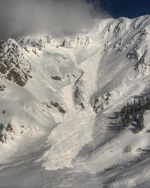
There were dry avalanches in the new snow on northerly facing slopes where ski patrols triggered some dry soft slabs. A large, dry slab avalanche that occurred first thing in the morning on the south face of Mt Superior. We are unsure of the trigger but it wasn't someone skiing the slope. Skiers on Kessler peak easily triggered fast moving dry snow sluffs yesterday.
On Tuesday there were several avalanches in the new snow including 
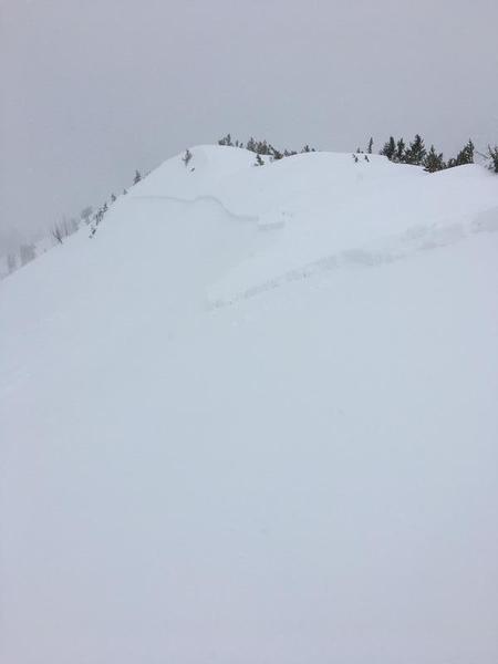
large slide was triggered in Days Fork with a ski cut, propagating much wider than expected, and entraining a lot of wet snow as it ran downhill. Other avalanches on Tuesday occurred in Dry Fork, on the AF side of Red Baldy,
Early morning avalanche yesterday on Mt. Superior (photo M. White).
Ski cut triggered slide in Days Fork on Tuesday, photo by JP
Ad
Avalanche Problem #1
Wet Snow
Type
Location
Likelihood
Size
Description
Today, wet avalanches will occur predictably as the snow warms and becomes wet. Most of these will be wet loose slides as in the video below. What this means is that the avalanche danger from wet avalanches starts LOW this morning but rises to CONSIDERABLE as the snow heats up. Most wet slides will occur on mid and upper elevations slopes facing east, south, and west. Wet avalanches are possible but less likely at low elevations that received rain with Tuesday's storm and have already gone through a cycle of wet slides.
Also, avoid being under any slope with a large glide crack. These are large cracks where the snow rest on a smooth ground surface and begins creeping/sliding downhill. At seemingly random times, these slopes can produce glide avalanches. Look for these large obvious cracks and just avoid hanging out beneath them.
Video below of a wet avalanche from Cardiac Ridge in Cardiff Fork (M. White).
Avalanche Problem #2
Wind Drifted Snow
Type
Location
Likelihood
Size
Description
The most likely dry snow avalanches today will be soft slabs of wind drifted snow. These wind slabs have a poor bond with the underlying snow and may remain unstable a little longer than normal. Snow unaffected by the wind may still sluff easily as it did yesterday on Kessler Peak.
Very strong south winds blew during the storm on Tuesday and top loaded some slopes. This morning at upper elevations strong northwest winds may have cross loaded other slopes. Look for signs of fresh wind drifts which look smooth, rounded, and pillowly. Usually I try to enter a slope from an different side or lower down to avoid these wind slabs.
General Announcements
This information does not apply to developed ski areas or highways where avalanche control is normally done. This forecast is from the U.S.D.A. Forest Service, which is solely responsible for its content. This forecast describes general avalanche conditions and local variations always occur.