Forecast for the Salt Lake Area Mountains

Greg Gagne
Issued by Greg Gagne for
Friday, April 14, 2023
The avalanche danger is Low.
The two avalanche problems to watch for are (1) cornices along exposed ridgelines at the mid and upper elevations, and (2) glide avalanches in terrain with glide cracks.

Slide-for-life conditions (where you are unable to arrest after falling) are possible on the smooth and frozen snow surface.
Low
Moderate
Considerable
High
Extreme
Learn how to read the forecast here
Special Announcements
The final UAC report for the Upper Weber Canyon avalanche accident on March 9 has been published and is available HERE. The UAC would like to thank Park City Powder Cats for sharing information about the timeline of the accident and allowing UAC staff access to the avalanche after the incident.
Weather and Snow
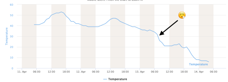
This Morning: After nearly four days of above-freezing temperatures, yesterday's cold front brought much-needed colder air and temperatures are now well-below freezing, with tmperatures in the single digits through mid-teens F. Winds are from the west/northwest and light, less than 10 mph, with 11,000' wind speeds gusting in the teens and low 20's mph. Skies are partly-cloudy. The temperature graph below from the Collins station shows the drop in temperatures with the arrival of colder air.
Today: Partly-cloudy skies with a chance for light snow showers this afternoon. Temperatures will be in the teens and 20's F and the west/northwest winds will be light through the mid elevations, gusting into the 20's mph along the highest ridges and summits.
This Weekend: Stronger winds overnight and into Saturday with mostly sunny skies and a warming trend that may provide decent corn conditions by late this weekend. A chance for light snow by midweek.
Recent Avalanches
No reports of avalanches on Thursday.
Ad
Avalanche Problem #1
Cornice
Type
Location
Likelihood
Size
Description
Huge cornices will be found along most exposed ridgelines at the mid and upper elevations. Although today's cold temperatures may make these cornices less sensitive, it is still possible to have a cornice collapse beneath you when traveling along a corniced ridgeline, and natural cornice falls are also possible. Any cornice that breaks will consist of Subaru-sized frozen chunks of snow that you do not want to be involved with.
Drew Hardesty has written about avalanche fatalities in the modern era in Utah and reports there have been six avalanche fatalities in Utah since 1940 due to cornice falls.
Avalanche Problem #2
Gliding Snow
Type
Location
Likelihood
Size
Description
Glide avalanches are extremely dangerous and destructive as the entire season's snowpack avalanches to the ground. One full depth glide avalanche on the Raymond Slabs in Porter Fork of Mill Creek released Tuesday. There are several visible glide cracks throughout the range, such as the glide crack in upper Mineral Fork in the photo below.
Today's colder temperatures do not help minimize glide avalanches as liquid water has already greased the smooth, rocky bed surfaces.
The locator rose for this avalanche problem is less helpful, and you should instead avoid traveling in areas known for glide avalanches such as Stairs Gulch, Broads Fork, Mill B South, Mineral Fork, and Porter Fork. We have had two accidents (including a fatality) with glide avalanches in the past 22 years:
General Announcements
This information does not apply to developed ski areas or highways where avalanche control is normally done. This forecast is from the U.S.D.A. Forest Service, which is solely responsible for its content. This forecast describes general avalanche conditions and local variations always occur.