Forecast for the Salt Lake Area Mountains

Greg Gagne
Issued by Greg Gagne for
Sunday, March 7, 2021
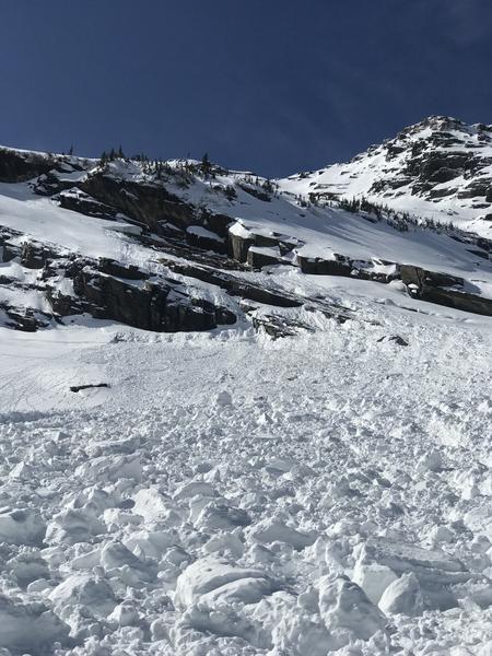
The avalanche danger is LOW. This means that human-triggered avalanches are unlikely, but small avalanches in isolated areas are possible. This includes (1) small, loose wet avalanches on aspects facing east, south, and west, as well as low and mid-elevation northerly slopes; (2) small pockets of fresh wind drifts in open alpine terrain and along exposed ridgelines.

Even with a forecasted Low danger rating, continue to maintain safe travel habits in avalanche terrain. This means exposing one person at a time and having someone watch them from a safe location, and not traveling above or below other parties.
Low
Moderate
Considerable
High
Extreme
Learn how to read the forecast here
Special Announcements
The UAC staff has published a blog with answers to the numerous questions we received but were not able to answer during the Q & A session for the online meeting regarding the Wilson Glades February, 6 accident.
Weather and Snow
Skies are partly cloudy and temperatures range through the 20's F. The south/southwest winds increased throughout the day yesterday, with the strongest winds late afternoon, including gusts over 70 mph at 11,000'. Winds have subsided somewhat, but are still averaging in the teens with gusts in the 20's mph at mid-elevations while averaging in the 20's with gusts in the 40's mph along the upper-most ridges.
For today, expect partly-cloudy skies with south/southwest winds and mountain temperatures rising above freezing. At the mid-elevations, winds will average in the teens with gusts in the 20's mph and temperatures rising to near 40° F. At the upper elevations, winds will average in the 20's and gusting in the 40's mph, with temperatures rising into the mid 30's F. The south/southwest winds will increase overnight and into Monday as unsettled weather enters our region. Although we can look forward to cooler temperatures, snow amounts this week currently appear lean.
There have been reports of folks finding decent soft snow in north-facing, upper elevation terrain, but moderate to strong winds over the past 24 hours have likely diminished opportunities for finding soft snow.

Our Week in Review - where we highlight significant avalanche and weather events from the past week - has been published.
Recent Avalanches
There were a few reports of minor wet loose avalanche activity on Saturday, including what appears to be a small glide avalanche in Broads Fork.
As always, you can find more details in the Observations and Avalanches tab on our website.
Ad
Avalanche Problem #1
Normal Caution
Type
Location
Likelihood
Size
Description
Normal caution advises generally safe avalanche conditions, with small avalanches in isolated areas possible. Two things to watch for today include:
1. Wet snow - The snowpack froze overnight and today's winds will help keep the snow surface cooler, but as the day heats up and the snow gets wet, it will be possible to trigger small, wet-loose avalanches. Although natural, wet-avalanche activity is likely to be minimal, is could be consequential if you are caught in a terrain trap or confined in a steep-sided gully such as this party on Thursday in the Y-Not Couloir.
2. Wind drifted snow - Moderate to strong winds over the past 24 hours have created small pockets of fresh wind drifted snow along exposed ridgelines and in open terrain in the alpine. Although these fresh wind drifts are likely to be small, they may be consequential in steep terrain.
The observation of what appears to be a glide avalanche in Broads Fork is a reminder that we are entering the season where glide avalanches become increasingly likely in terrain such as Broads Fork, Mill B South, and Stairs Gulch. The timing of these events is unpredictable, but glide avalanches can be very large and run to the valley bottoms.
Additional Information
What happened to the persistent weak layer near the ground? The layer still exists but it is mostly dormant, and we don't expect avalanches to happen on it until something changes in the weather. A major spring storm with feet of new snow could awaken this layer. It also may be a problem again on slopes that produced big avalanches following the series of storms that happened near Valentine's day in the middle of February.
General Announcements
Please visit this website with information about Responsible Winter Recreation by the Utah Office of Outdoor Recreation.

This information does not apply to developed ski areas or highways where avalanche control is normally done. This forecast is from the U.S.D.A. Forest Service, which is solely responsible for its content. This forecast describes general avalanche conditions and local variations always occur.