Forecast for the Salt Lake Area Mountains

Trent Meisenheimer
Issued by Trent Meisenheimer for
Saturday, March 4, 2023
The avalanche danger is CONSIDERABLE on upper elevation slopes that face northwest, north, northeast, east, and southeast for wind-drifted snow avalanches. Here it is likely to trigger a new or old wind slab that could be 1-2 feet deep.

Elsewhere, there is a MODERATE avalanche danger where avalanches may fail within the new storm snow or wind-drifted snow 1-2 feet deep. Larger avalanches failing 2-6 feet deep are also possible.
Low
Moderate
Considerable
High
Extreme
Learn how to read the forecast here
Special Announcements
To help you safely enjoy the backcountry, the UAC team is constantly evaluating and implementing new programs and technologies. Donate to the Spring Campaign to help our team implement innovative tools and better provide you with the information you rely on.
Weather and Snow
Under mostly cloudy skies, the mountain temperatures remain cold, with many stations in the single digits and some just climbing into the low to mid-teens °F. Winds now blow from the southwest and picked up in the last few hours, blowing 15-20 mph and gusting into the low 30s across many of the upper elevation ridglines. In the past 24 hrs, we picked up another 3-7 inches of new snow, with plenty more on the way.
This morning, the National Weather Service issued a Winter Weather Advisory from 11:00 am this morning to 11:00 am Sunday. As the storm approaches this morning, we will remain under a southwest flow, and it will strengthen throughout the day with southerly winds peaking around 11:00 am at speeds of 15-25 mph, gusting to 45 mph. Snow will develop by mid-morning, favoring locations that do well on a southerly flow. We can expect roughly 2-5 inches of new snow by the dinner hour. Overnight the cold front comes through and will then favor the Upper Cottonwoods. All said and done. We could see 1-2 feet (0.75-1.25" water) of new snow by tomorrow morning.
Recent Avalanches
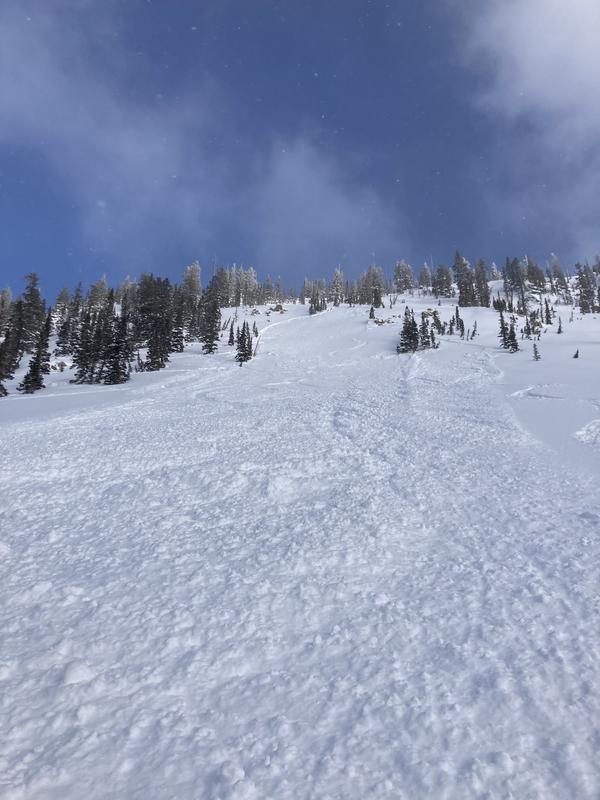
Yesterday was a relatively quiet day in terms of observations or avalanches reported. We did get one reported avalanche on Mt. Millicent on the northwest side at 10,000' (photo below). The avalanche was skier triggered and failed within the new snow 10 inches deep and 70 feet wide. The skier was not caught or carried. Be sure to catch up on all recent observations HERE.
Ad
Avalanche Problem #1
Wind Drifted Snow
Type
Location
Likelihood
Size
Description
Winds have already picked up from the southwest and will only increase throughout the day today. Winds are forecast to blow southwest 15-25 mph with gusts into the 40s. As a result, we can expect the wind to grab yesterday's and today's low-density snow and deposit it onto lee slopes, creating a fresh batch of wind-drifted snow. These avalanches are likely to be 1-2 feet deep and could be 100 feet wide. Watch for and avoid slopes that are being actively loaded by the wind.
It just won't stop snowing! And the past week's snow totals have been mind-bending (6 feet of snow with strong winds), and to think about the sheer amount of new snow or weight hanging in the balance in the upper starting zones is enough to make me take a step back. Cornice fall or old hard slabs that simply cannot hold any more weight could also fail, creating a much more dangerous and deeper avalanche 2-6 feet deep.
Avalanche Problem #2
New Snow
Type
Location
Likelihood
Size
Description
Yesterday and today's new snowfall will be enough to create sensitive shallow soft slabs of new snow as well as some long-running sluffs in steeper terrain. Be on the lookout for any period of intense snowfall, as this could spike the avalanche danger immediately.
Avalanches can also break down deeper into a variety of relatively "weaker" layers in the snowpack as Thursday's deeper avalanches demonstrated. I would advise taking a step back during this next loading event and letting the mountains adjust to the recent storm snow. It won't be long before the snowpack becomes stable once again.
Additional Information
Fun fact: Lots of assumptions here, but the average football field is 120 yards long by 53 yards wide (109m x 49m). We could easily calculate the volume if we took the water weight from last week's snowfall and filled this football field with 6 inches of water (0.1524m). We can get the mass from volume by remembering that mass = (density)(volume). Plugging in the numbers: mass = (1000 kg/m^3)(814.83m^3).
Mass = 814,830kg or 1,796,392 lbs. That's equivalent to 1,800 grand pianos or 4.36 jumbo jets hanging in space. Remember, this is just a football field. Some starting zones have multiple football fields. If you have some free time, calculate the potential energy of this using some basic trigonometry, and remember that PE = (density)(gravity)(height). We could assume no friction to make math easier. Anyway, it's a lot of weight.
General Announcements
This information does not apply to developed ski areas or highways where avalanche control is normally done. This forecast is from the U.S.D.A. Forest Service, which is solely responsible for its content. This forecast describes general avalanche conditions and local variations always occur.