If you rely on the UAC forecasts each day you get out, consider making a donation during our
Spring Awareness Campaign to help us continue providing the avalanche forecasts and education you rely on.
Though outdoor recreation is still permitted under the governor’s Stay Safe/Stay Home directive, we recommend that people maintain a distance of at least 6 feet.
Be extra cautious to avoid injuries outdoors. We are working with our hospital systems to conserve as much personal protective equipment as possible in case of hospitalizations.
Most outdoor injuries can be prevented. Know the conditions and know your limits so you don’t end up in a hospital.
Skies are overcast with light snow falling in the mountains. We're up to 2-5" of new snow, generally 5% density. Temperatures are in the mid to upper teens.
The west-northwest winds picked up overnight and are blowing 10-15mph with gusts to 30. The highest elevation anemometers, however, are seeing hourly averages of 30-35mph with a few gusts to 50.
Riding conditions will remain excellent on northerly aspects, particularly in wind sheltered terrain. Many east to south to west aspects will have sucker snow above a breakable crust. But it's been a good run: storm totals since Wednesday are roughly 20-30".
Springtime in the Wasatch. We'll have snow showers that'll mostly wind down over the course of the day. We could see another inch or two...with skies turning partly cloudy this afternoon. Winds should remain gusty from the west northwest before losing steam and gently backing to the west and southwest. Temps will warm to the low to mid-20s. Another weak wave moves in tomorrow that may produce another couple inches with another quick hitting storm on Tuesday.
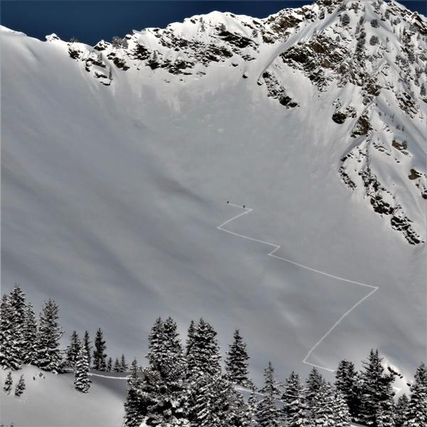
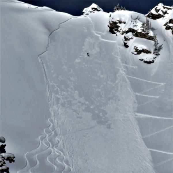
It was a fairly active avalanche day in the Wasatch yesterday with people swarming the range. Many, many close calls: people caught and carried, airbags deployed, people swept over cliffbands, someone carried up into a tree as debris washed by....Yes, quite active yesterday...and fortunately only some minor scrapes and a lost ski pole or two.
By my count, there were about ten human triggered avalanches with six people caught and carried in three separate incidents in the central Wasatch with another three caught and two carried in the Ogden area mountains. I mostly attribute these numbers to the natural challenges of adequate
social distancing on the up-track, ill-considered "safe-zones", and inherent risks of radical terrain (ie: Superior and Mt Ogden). A close look at a very close call yesterday in the No-Name area of the closed-for-the-season Snowbasin resort can be found
HERE.
These soft slab avalanches were generally 1-2' deep and reportedly up to 300' wide on upper elevation primarily northeast to southeast facing terrain. The soft slabs involved either fresh wind drifts or still-tender interfaces of the storm snow on last weekend's crusts. In many cases, the avalanches broke above the person on ascent, making escape difficult if not impossible. All of these observations and avalanches can be found in the menu above. Thanks to all who submitted info.
+Observer Charlie Hussey has a before/after photo of Cardiac Ridge, below.+