If you rely on the UAC forecasts each day you get out, consider making a donation during our
Spring Awareness Campaign to help us continue providing the avalanche forecasts and education you rely on.
Though outdoor recreation is still permitted under the governor’s Stay Safe/Stay Home directive, we recommend that people maintain a distance of at least 6 feet.
Be extra cautious to avoid injuries outdoors. We are working with our hospital systems to conserve as much personal protective equipment as possible in case of hospitalizations.
Most outdoor injuries can be prevented. Know the conditions and know your limits so you don’t end up in a hospital.
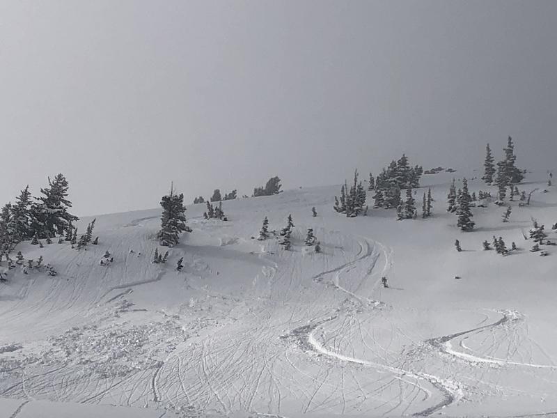
We have mostly cloudy to overcast skies across the range this morning as a weak, splitting storm system moves through. Mountain temperatures are in the mid to upper teens. Winds are hardly a whisper.
I wouldn't rule out a few snow showers here and there today that may add up to an inch or two. Temps will rise to the low 20s up high today, the low 30s down low. Looking down the road, we have a storm passing to the north on Tuesday that might be good for a 4-8" refresher, favoring the Ogden and Logan area mountains...and generally unsettled weather beyond that.
Riding conditions remain quite good in the usual wind and sun sheltered terrain.
Fresh wind drifts 6-12" deep were sensitive along the highest elevations in the morning, but became increasingly stubborn by afternoon. Sluffing of the new low density snow was also noted....along with some damp push-alanches from the afternoon greenhousing on low/mid elevation slopes.
Backcountry skiers continued to trigger pockets of soft slab avalanches yesterday. (More info found in the Menu bar above. Locations found on wbskiing.com). Some looked to be new wind drifts, some looked to be avalanches failing on the mid-week graupel, some looked to be failing on the the pre-storm bed surface.
- Tuscarora - 10,300' South facing 6"x 20' wide (pic)
- Banana Days - 9300' East facing 10"x 60' wide. One skier caught and carried.
- Coalpit #3 - 8900' North facing 12"x 80' wide
- Katie's - 9900' North facing 10"x 25' wide
- Greeley Bowl - 9200' Southeast facing 16"x 15' wide
A report came in from a very close call on Friday from the Maybird couloir in mid-Little Cottonwood Canyon...one of the very steep avalanche paths that serially threatens LCC. Write-up
HERE. Recommend reading.
We greatly appreciate all reports from the community as this helps us better understand the nature of the snowpack and improves the accuracy of our forecasts. Thank you. I also highly recommend following us on Instagram @utavy and #utavy. Some breathtaking footage and personal accounts have been posted in recent days.