Join us at our 2nd Annual Blizzard Ball

Forecast for the Salt Lake Area Mountains

Mark Staples
Issued by Mark Staples on
Saturday morning, March 27, 2021
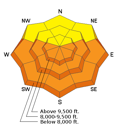
Today the avalanche danger will rise to CONSIDERABLE on east, south and west facing terrain as the snow becomes wet. Wet avalanches should happen naturally. Most should be wet loose avalanches but shallow wet slabs are possible. The danger will rise to MODERATE even on north facing slopes if the snow becomes wet.
Go to upper elevation north facing terrain where the snow remains dry; however, be watching for any terrain above where the snow may heat up quicker than you realize. Exposed rocks readily absorb sunshine and quickly heat up the snow around them.
Low
Moderate
Considerable
High
Extreme
Learn how to read the forecast here
Special Announcements
The 2021 Spring Awareness Campaign is underway. Help us save lives through avalanche forecasts and education. Consider making a donation to show your support HERE.
Weather and Snow
Yesterday skies were mostly cloudy in the morning and produced a trace to 1 inch of snow. In the afternoon clouds dissipated and some sunshine appeared. This morning temperatures are mostly in upper teens F, and winds are blowing 10 mph gusting to 20 mph at most ridgelines from the northwest and west.
Today will be warm and sunny with light winds. Temperatures will quickly climb into the 30s and low 40s F. Winds will blow from the north and ease blowing only about 5-10 mph.
Looking ahead, Sunday will be similar to today but warmer. A cold front will cross northern Utah on Monday and bring much colder temperatures. Unfortunately there won't be much moisture in this system.

Our Week in Review - where we highlight significant snow and avalanche events from this past week - has been published.
Recent Avalanches
There was some sluffing of the new snow reported yesterday. One party approaching the Y Couloir early yesterday morning found a sizable debris pile at the base from a sluff of new snow.
More relevant for today's avalanche issues was a wet slab avalanche that happened yesterday at Elk Point on Mt Timpanogos. It was 6 inches deep and about 200 feet wide. Wet slabs are very hard to predict, but when one happens it should make us pay attention because others may happen.
Ad
Avalanche Problem #1
Wet Snow
Type
Location
Likelihood
Size
Description
Today's warm temperatures and strong sunshine will be a big change to layers of new snow from last weekend (12-24 inches) and from Thursday (up to 4 inches). This past week has had periods of sunshine and warm temperatures but no sustained warm, sunny weather like today.
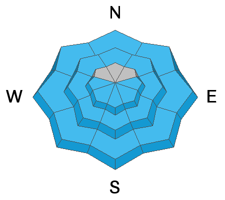
The upper foot of snow should quickly become wet today starting with east facing slopes that receive the first sunshine and then quickly going to south and then west facing slopes. Even the snow on north facing slopes at low elevations and some mid elevations should become wet as the day heats up.
Honestly, I'm a bit uncertain exactly how the snow will react. As the snow becomes wet, there should be wet loose avalanches. However, what's causing me concern is yesterday's wet slab avalanche reported on Elk Point on Mt. Timpanogos. There could be more like it or there could be none, it's just hard to say.
Look for clues that the likelihood of wet avalanches is increasing. As the snow gets wetter and you see more and more pinwheels and rollerballs tumbling downhill, the likelihood of wet avalanches is increasing.
General Announcements
Please visit this website with information about Responsible Winter Recreation by the Utah Office of Outdoor Recreation.

This information does not apply to developed ski areas or highways where avalanche control is normally done. This forecast is from the U.S.D.A. Forest Service, which is solely responsible for its content. This forecast describes general avalanche conditions and local variations always occur.